
The Lower Mainland is a geographic and cultural region of the mainland coast of British Columbia that generally comprises the regional districts of Metro Vancouver and the Fraser Valley. Home to approximately 3.05 million people as of the 2021 Canadian census, the Lower Mainland contains sixteen of the province's 30 most populous municipalities and approximately 60% of the province's total population.

The Fraser River is the longest river within British Columbia, Canada, rising at Fraser Pass near Blackrock Mountain in the Rocky Mountains and flowing for 1,375 kilometres (854 mi), into the Strait of Georgia just south of the City of Vancouver. The river's annual discharge at its mouth is 112 cubic kilometres (27 cu mi) or 3,550 cubic metres per second (125,000 cu ft/s), and each year it discharges about 20 million tons of sediment into the ocean.

The Fraser Valley is a geographical region in southwestern British Columbia, Canada and northwestern Washington State. It starts just west of Hope in a narrow valley encompassing the Fraser River and ends at the Pacific Ocean stretching from the North Shore Mountains, opposite the city of Vancouver BC, to just south of Bellingham, Washington.

Mission is a city in the Lower Mainland of the province of British Columbia, Canada. It was originally incorporated as a district municipality in 1892, growing to include additional villages and rural areas over the years, adding the original Town of Mission City, long an independent core of the region, in 1969. It is bordered by the city of Abbotsford to the south and the city of Maple Ridge to the west. To the east are the unincorporated areas of Hatzic and Dewdney.
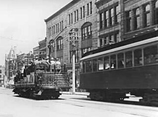
The British Columbia Electric Railway (BCER) was an historic railway which operated in southwestern British Columbia, Canada. Originally the parent company for, and later a division of, BC Electric Company, the BCER assumed control of existing streetcar and interurban lines in southwestern British Columbia in 1897, and operated the electric railway systems in the region until the last interurban service was discontinued in 1958. During and after the streetcar era, BC Electric also ran bus and trolleybus systems in Greater Vancouver and bus service in Greater Victoria; these systems subsequently became part of BC Transit, and the routes in Greater Vancouver eventually came under the control of TransLink. Trolley buses still run in the City of Vancouver with one line extending into Burnaby.

Ladner is a part of the City of Delta, British Columbia, Canada, and a suburb of Vancouver, British Columbia. It was created as a fishing village on the banks of the Fraser River.

The Fraser Valley Regional District (FVRD) is a regional district in British Columbia, Canada. Its headquarters are in the city of Chilliwack. The FVRD covers an area of 13,361.74 km² (5,159 sq mi). It was created in 1995 by an amalgamation of the Fraser-Cheam Regional District and Central Fraser Valley Regional District and the portion of the Dewdney-Alouette Regional District from and including the District of Mission eastwards.
Ruskin is a rural, naturally-treed community, about 35 mi (56 km) east of Vancouver on the north shore of the Fraser River. It was named around 1900 after of the English art critic, essayist, and prominent social thinker John Ruskin.
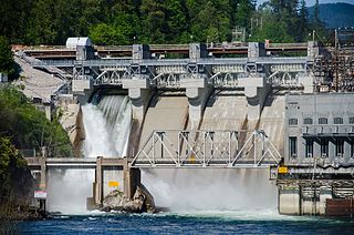
The Stave River is a tributary of the Fraser, joining it at the boundary between the municipalities of Maple Ridge and Mission, about 35 kilometres (22 mi) east of Vancouver, British Columbia, Canada, in the Central Fraser Valley region.
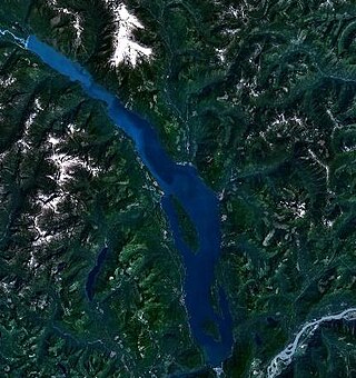
Harrison Lake is the largest lake in the southern Coast Mountains of Canada, being about 250 square kilometres (95 mi²) in area. It is about 60 km (37 mi) in length and at its widest almost 9 km (5.6 mi) across. Its southern end, at the resort community of Harrison Hot Springs, is c. 95 km east of downtown Vancouver. East of the lake are the Lillooet Ranges while to the west are the Douglas Ranges. The lake is the last of a series of large north-south glacial valleys tributary to the Fraser along its north bank east of Vancouver, British Columbia. The others to the west are the Chehalis, Stave, Alouette, Pitt, and Coquitlam Rivers.

The Pitt River in British Columbia, Canada is a large tributary of the Fraser River, entering it a few miles upstream from New Westminster and about 25 km ESE of Downtown Vancouver. The river, which begins in the Garibaldi Ranges of the Coast Mountains, is in two sections above and below Pitt Lake and flows on a generally southernly course. Pitt Lake and the lower Pitt River are tidal in nature as the Fraser's mouth is only a few miles downstream from their confluence.

The Rocky Mountain Trench, also known as the Valley of a Thousand Peaks or simply the Trench, is a large valley on the western side of the northern part of North America's Rocky Mountains. The Trench is both visually and cartographically a striking physiographic feature extending approximately 1,600 km (1,000 mi) from Flathead Lake, Montana, to the Liard River, just south of the British Columbia–Yukon border near Watson Lake, Yukon. The trench bottom is 3–16 km (1.9–9.9 mi) wide and is 600–900 m (2,000–3,000 ft) above sea level. The general orientation of the Trench is an almost straight 150/330° geographic north vector and has become convenient as a visual guide for aviators heading north or south.
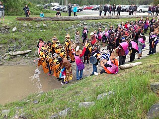
Kwantlen First Nation is a First Nations band government in British Columbia, Canada, located primarily on McMillan Island near Fort Langley. The Kwantlen people traditionally speak hən̓q̓əmin̓əm̓, the Downriver dialect of Halkomelem, one of the Salishan family of languages.

Sumas Lake(Halq’eméyle: Semá:th Lake, Nooksack: Semáts Xácho7, ) was a shallow freshwater lake surrounded by extensive wetlands that once existed in eastern Fraser Lowland, located on the south side of the Sumas River between the foothills of Sumas Mountain and Vedder Mountain. It disappeared after being artificially drained for flood control and land reclamation from 1920 to 1924, leaving behind a low-lying flatland known as the Sumas Prairie, which is nowadays drained by the Saar Creek and the namesaked Sumas Drainage Canal.
Silverdale is a semi-rural neighbourhood of the District of Mission, British Columbia, Canada, located about 40 km east of Vancouver on the east bank of the Stave River at its confluence with the Fraser. Noted for its historic Italian Canadian community, its economy was farming, fishing and logging based until the general suburbanization of Fraser Valley life in the 1960s and 1970s. Of its Italian community, notable offspring include Phil Gaglardi, former BC Highways minister, and speed-skater Eden Donatelli. Silverdale is also notable as the site of Canada's first train robbery, by the "Gentleman Bandit" Billy Miner, and it is there he is supposed to have first used the polite "Hands Up!" in the course of the robbery.
Pemberton Pass, 505 m (1,657 ft), also formerly known as Mosquito Pass, is the lowest point on the divide between the Lillooet and Fraser River drainages, located at Birken, British Columbia, Canada, in the principal valley connecting and between Pemberton and Lillooet. The pass is a steep-sided but flat-bottomed valley adjacent to Mount Birkenhead and forming a divide between Poole Creek, a tributary of the Birkenhead River, which joins the Lillooet at Lillooet Lake, and the Gates River which flows northeast from Gates Lake, at the summit of the pass, which flows to the Fraser via Anderson and Seton Lakes and the Seton River.
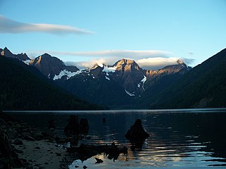
Wahleach Lake, commonly known as Jones Lake, is a lake and reservoir located in the Skagit Range in the Lower Mainland of British Columbia, Canada, east of the city of Chilliwack and southwest of the town of Hope.

The Old Yale Road is a historic early wagon road between New Westminster, British Columbia, Canada and Yale, British Columbia, and servicing the Fraser Valley of the British Columbia Lower Mainland in the late 19th century and into the early 20th. It eventually became an early highway route for automobiles through the valley and into the British Columbia interior beyond Yale. It would eventually be part of, then surpassed by, the Fraser Highway, the Trans-Canada Highway and the Highway 1.

Hatzic is a historic community in the Central Fraser Valley region of the Lower Mainland of British Columbia, Canada, located on the east side of the City of Mission and including areas beyond the municipal boundary to the east and northeast.
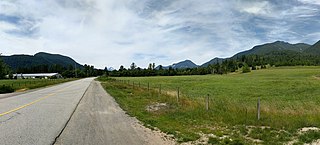
The Hatzic Valley is the southerly, lowland portion of the Fraser Valley Regional District Electoral Area "F" of British Columbia's Lower Mainland. The valley was carved as a result of southward glacial action, being "centered along a low‐lying glacial trough that extends from Stave Lake to the Fraser Valley."


