
Lillooet is a district municipality in the Squamish-Lillooet region of southwestern British Columbia. The town is on the west shore of the Fraser River immediately north of the Seton River mouth. On BC Highway 99, the locality is by road about 100 kilometres (62 mi) northeast of Pemberton, 64 kilometres (40 mi) northwest of Lytton, and 172 kilometres (107 mi) west of Kamloops.

Seton Portage is a community on a narrow strip of land between Anderson Lake and Seton Lake in Squamish-Lillooet Regional District, British Columbia. The community is home to two Seton Lake First Nation communities at either end of the portage and a non-native recreational community between them. Local services include a post office, fire department, library, and general store, among other small businesses. The community is also the location of Seton Portage Historic Provincial Park, a small provincial park protecting a historically significant stretch of railway.
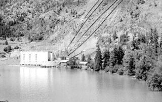
Shalalth and South Shalalth are unincorporated communities on the northern shore near the western end of Seton Lake in the Squamish-Lillooet region of southwestern British Columbia. The localities are by road about 63 kilometres (39 mi) northwest of Lillooet, but only 24 kilometres (15 mi) by rail.

The Bridge River is an approximately 120 kilometres (75 mi) long river in southern British Columbia. It flows south-east from the Coast Mountains. Until 1961, it was a major tributary of the Fraser River, entering that stream about six miles upstream from the town of Lillooet; its flow, however, was near-completely diverted into Seton Lake with the completion of the Bridge River Power Project, with the water now entering the Fraser just south of Lillooet as a result.

The Cayoosh Gold Rush was one of several in the history of the region surrounding Lillooet, British Columbia, Canada. If estimates of its yield are true, it would be one of the richest single finds in the gold mining history of that province.

A quiggly hole, also known as a pit-house or simply as a quiggly or kekuli, is the remains of an earth lodge built by the First Nations people of the Interior of British Columbia and the Columbia Plateau in the United States. The word quiggly comes from a mispronunciation of the nsyilxcǝn term qʷc̓iʔ, which was incorporated into Chinook Jargon as kickwillie. Kick willy, kickwillie, or keekwulee are the spelling variations of the Chinook Jargon word for "beneath" or "under".
N'Quatqua, variously spelled Nequatque, N'quat'qua, is the proper historic name in the St'at'imcets language for the First Nations village of the Stl'atl'imx people of the community of D'Arcy, which is at the upper end of Anderson Lake about 35 miles southeast of Lillooet and about the same distance from Pemberton. The usage is synonymous with Nequatque Indian Reserve No. 1, which is 177 ha. in size and located adjacent to the mouth of the Gates River.
Tyaughton Creek, formerly gazetted as the Tyaughton River, also historically known as Tyoax Creek, is a 50 kilometre tributary of British Columbia's Bridge River, flowing generally southeast to enter the main flow of that river about mid-way along the length of Carpenter Lake, a reservoir formed by Terzaghi Dam of the Bridge River Power Project.
Tyaughton Lake, also known as Tyax Lake, is a lake in the Bridge River Country of the West-Central Interior of British Columbia, Canada, located to the north of Carpenter Lake, a reservoir along the Bridge River formed by Terzaghi Dam of the Bridge River Power Project. Among the largest of a number of well-known fishing lakes located in valleys flanking the Bridge River, its name is an adaptation of a Chilcotin word meaning "jumping fish". Around its shores is a community of recreational homes, and near its southern end had been an older fishing lodge, the Tyaughton Lake Lodge, while on its northwestern shore is the Tyax Mountain Lake Resort, built in the 1980s, which at the time of construction was the largest log structure built in British Columbia in the 20th Century. Despite the shared name, it is not directly on the course of Tyaughton Creek, but is linked to the lower canyon of that creek by a short intermediary stream. The main road access is from the Gun Creek Forest Service Road from a junction on BC Highway 40 (the Gold Bridge-Lillooet Road midway between the outlets into Carpenter Lake of Tyaughton Creek and Gun Creek.
Minto City, often called just Minto, sometimes Minto Mines,Minto Mine, Skumakum, or "land of plenty", was a gold mining town in the Bridge River Valley of British Columbia from 1930 to 1936, located at the confluence of that river with Gun Creek, one of its larger tributaries. The mine prospect was never much successful although a model townsite was built by promoter "Big Bill" Davidson, who imported soil to build a specially-built rodeo ground and baseball diamond on the rocky site. The larger mine of Bralorne was nearby. The mine shut down in 1936 due to productivity issues, but restarted in 1940. The valley has since been significantly altered when most of the vestiges of the town were inundated by the waters of the Carpenter Lake reservoir following completion of the Bridge River Power Project. In 1941, around two dozens of Japanese Canadian families were relocated to Minto Mine, and ordered to live in the empty miners' houses due to the impacts of the war.

Gold Bridge is an unincorporated community in the Bridge River Country of British Columbia, Canada. Although numbering only around 40 inhabitants, Gold Bridge is the service and supply centre for the upper basin of the Bridge River Valley, which includes recreation-residential areas at the Gun Lakes, Tyaughton Lake, Marshall Creek, and Bralorne; and the nearby ghost towns of Brexton and Pioneer Mine.
The Bridge River Power Project is a hydroelectric power development in the Canadian province of British Columbia, located in the Lillooet Country between Whistler and Lillooet. It harnesses the power of the Bridge River, a tributary of the Fraser, by diverting it through a mountainside to the separate drainage basin of Seton Lake, utilizing a system of three dams, four powerhouses and a canal.
Bridge River was used to describe three separate towns or localities in the Lillooet Country of the Interior of British Columbia connected with the river and valley of the same name.
Mount Downton is the highest summit of the 10 km (6 mi) diameter Itcha Range, located 40 km (25 mi) northeast of Anahim Lake and 33 km (21 mi) east of Far Mountain in the Chilcotin District of the Central Interior of British Columbia, Canada. It lies within Itcha Ilgachuz Provincial Park.
Neal "Curly" Evans was a freight industry entrepreneur in the Bridge River–Lillooet Country of the Interior of British Columbia, Canada. He acquired a reputation in that region for his enterprise, daring, and personality.
McGillivray, formerly McGillivray Falls, is an unincorporated recreational community on the west shore of Anderson Lake, just east of midway between the towns of Pemberton and Lillooet, British Columbia, Canada, in that province's southwest Interior.

Cayoosh Creek is a northeast-flowing tributary of the Seton River in the Canadian province of British Columbia. The name Cayoosh Creek remains on the bridge-sign crossing the stream on BC Highway 99 and continues in use locally to refer to the final reaches of the Seton River, formerly Seton Creek, which prior to the renaming ending at the confluence with Cayoosh Creek. The creek is the namesake of Cayoosh Creek Indian Reserve No. 1, one of the main Indian reserves of the Cayoose Creek Indian Band, which lies adjacent to what was renamed the Seton River without local consultation.
Gun Lake, often spelled Gunn Lake and also known as Big Gun Lake, is a lake and unincorporated community in the Bridge River Country of the West-Central Interior of British Columbia, Canada, located 5 miles northwest of the community of Gold Bridge. It is approximately 6 km in length and is roughly pistol-shaped when seen from above, and drains via a short connecting creek to Gun Creek, which is an important tributary of the Bridge River, joining it via Carpenter Lake. Lajoie Lake, which is just southwest, is also known as Little Gun Lake and is also a small community. The two together are generally referred to as the Gun Lakes.
The Bridge River Rapids, also known as the Six Mile Rapids, the Lower Fountain, the Bridge River Fishing Grounds, and in the St'at'imcets language as Sat' or Setl, is a set of rapids on the Fraser River, located in the central Fraser Canyon at the mouth of the Bridge River six miles north of the confluence of Cayoosh Creek with the Fraser and on the northern outskirts of the District of Lillooet, British Columbia, Canada.
