
The Clearwater River is the largest tributary of the North Thompson River, joining it at the community of Clearwater, British Columbia. The Clearwater rises from glaciers in the Cariboo Mountains and flows in a mostly southerly direction for 201 km (125 mi) to the North Thompson. Its entire course, except the last 5 km (3 mi), is within Wells Gray Provincial Park. Its confluence with the North Thompson is protected by North Thompson River Provincial Park.

Pyramid Mountain is a subglacial mound located on the Murtle Plateau in Wells Gray Provincial Park, east-central British Columbia, Canada.
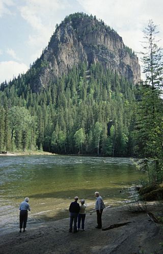
White Horse Bluff is a subaqueous volcano in Wells Gray Provincial Park, east-central British Columbia, Canada.
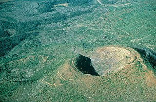
Dragon Cone is a monogenetic cinder cone located in Wells Gray Provincial Park in east-central British Columbia. It is the source of a 15 km (9 mi) long lava flow, called Dragon's Tongue. This lava covered the floor of narrow Falls Creek Valley and terminated at the Clearwater River, damming it to a height of 3 m (10 ft) and raising the level of existing Clearwater Lake upstream. Geologists have recovered some peat buried by the lava and radiocarbon dating produced an age of 7560 years plus or minus 100 years. Flows from nearby Flourmill Cone, Kostal Cone and Spanish Lake Cones rest on glaciated bedrock without an intervening paleosol, suggesting an early Holocene age.

Mount Ray, also known as Ray Mountain, is a subglacial mound in Wells Gray Provincial Park, British Columbia, Canada. Mount Ray last erupted during the Pleistocene. It is part of the Wells Gray-Clearwater volcanic field.
Buck Hill is a hill in east-central British Columbia, Canada, located 17 km (10.6 mi) north of Clearwater. It rises from the west slope of Trophy Mountain. Buck Hill is just outside the boundary of Wells Gray Provincial Park.
The Flourmill Volcanoes, also known as The Flourmills, are a small volcano range near the west boundary of Wells Gray Provincial Park in east-central British Columbia, Canada. Located north of Mahood Lake and west of the Clearwater River, they form part of the Wells Gray-Clearwater volcanic field.
McLeod Hill is a tuya, located 41 km (25 mi) north of Clearwater in the Wells Gray-Clearwater volcanic field in Wells Gray Provincial Park, east-central British Columbia, Canada.

Spahats Creek Falls, also called Spahats Falls, is a waterfall on Spahats Creek within Wells Gray Provincial Park of British Columbia, Canada. Common references place the falls at around 60 m (197 ft) tall, but taking into account the second tier, it is closer to 75–80 meters tall. It is a popular stop for tourists and especially motorcoach tours since it is only 10 km (6.2 mi) off the busy Yellowhead Highway.

Canim Falls is a 25 metre high waterfall on the Canim River between Canim Lake and Mahood Lake in Wells Gray Provincial Park in the Cariboo region of the Central Interior of British Columbia, Canada. The waterfall has eroded steadily upstream and created a 4 km (2.5 mi) long canyon cut into a lava plateau associated with the Wells Gray-Clearwater volcanic field.
Mahood Lake is a lake in the South Cariboo region of the Interior of British Columbia in Wells Gray Provincial Park. It is drained by the Mahood River, a tributary of the Clearwater River which has cut a deep canyon into Cambrian rocks and Pleistocene glacial moraines. Mahood Lake is fed by the short Canim River, which drains nearby Canim Lake to the west via Canim Falls and Mahood Falls.
The Canim River is a river in the South Cariboo region of the Interior of British Columbia, Canada. It begins at the outlet of Canim Lake and runs 1.8 km (1.1 mi) to Canim Falls, then continues 8 km (5.0 mi) via a canyon cut into a lava plateau to Mahood Lake. A second outlet from Canim Lake, also part of the Canim River, flows over Mahood Falls and joins the Canim Falls branch.

Kostal Lake is a lake located in Wells Gray Provincial Park, east-central British Columbia, Canada. It is located west of Murtle Lake and east of Clearwater Lake.
Ray Lake is a lake located in Wells Gray Provincial Park, east-central British Columbia, Canada. It is fed by and drained by Falls Creek which flows into the Clearwater River at its outlet from Clearwater Lake.
The Wells Gray-Clearwater volcanic field, also called the Clearwater Cone Group, is a potentially active monogenetic volcanic field in east-central British Columbia, Canada, located approximately 130 km (81 mi) north of Kamloops. It is situated in the Cariboo Mountains of the Columbia Mountains and on the Quesnel and Shuswap Highlands. As a monogenetic volcanic field, it is a place with numerous small basaltic volcanoes and extensive lava flows.
McDougall Lake is a lake in Wells Gray Provincial Park in east-central British Columbia, Canada. It drains through File Creek into Murtle Lake.

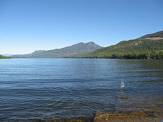
Azure Lake is a fjord-like lake located in east-central British Columbia, Canada. It is an expansion of the Azure River which rises from an unnamed glacier in the Cariboo Mountains. The outflow is also called the Azure River, but it is only 50 m (164 ft) long before it flows into the Clearwater River. Azure Lake is one of the six major lakes in Wells Gray Provincial Park.
Hobson Lake is the uppermost lake on the Clearwater River in east-central British Columbia, Canada. Hobson Lake is one of the six major lakes in Wells Gray Provincial Park.

Wells Gray Provincial Park is a large wilderness park located in east-central British Columbia, Canada. The park protects most of the southern, and highest, regions of the Cariboo Mountains and covers 5,415 square kilometres. It is British Columbia's fifth largest provincial park, after Tweedsmuir, Tatshenshini, Spatsizi and Northern Rocky Mountains.

Mount Hugh Neave is a mountain in east-central British Columbia, Canada, located between Hobson Lake to the west and Goat Creek to the south. Situated in the Cariboo Mountains of the Columbia Mountains, it is the seventh highest mountain in Wells Gray Provincial Park with an elevation of 2,829 m (9,281 ft).


