Whistler Blackcomb is a ski resort located in Whistler, British Columbia, Canada. By many measures it is the largest ski resort in North America and has the greatest uphill lift capacity. It features the Peak 2 Peak Gondola for moving between Whistler and Blackcomb mountains at the top. With all of this capacity, Whistler Blackcomb is also often the busiest ski resort, often surpassing 2 million visitors a year.

Heavenly Mountain Resort is a ski resort located on the California–Nevada border in South Lake Tahoe in the Sierra Nevada Mountain Range. It opened for business on December 15, 1955 and has 97 runs and 30 lifts that are spread between California and Nevada and four base facilities. The resort has 4,800 acres (1,900 ha) within its permit area, with approximately 33% currently developed for skiing, boasting the highest elevation of the Lake Tahoe area resorts with a peak elevation of 10,067 ft (3,068 m), and a peak lift-service elevation of 10,040 ft (3,060 m).

Whistler is a resort municipality in the southern Pacific Ranges of the Coast Mountains in British Columbia, Canada. Approximately 125 km (78 mi) north of Vancouver and 36 km (22 mi) south of Pemberton, it is incorporated as the Resort Municipality of Whistler (RMOW). It has a permanent population of approximately 11,854, as well as a larger but rotating population of seasonal workers, who are typically younger people from beyond British Columbia, notably from Australia and Europe.

Garibaldi Provincial Park, also called Garibaldi Park, is a wilderness park located on the coastal mainland of British Columbia, Canada, located 70 kilometres (43.5 mi) north of Vancouver. It was established in 1920 and named a Class A Provincial Park of British Columbia in 1927. The park is a popular destination for outdoor recreation, with over 30,000 overnight campers and over 106,000 day users in the 2017/2018 season.

The Cheakamus River is a tributary of the Squamish River, beginning on the west slopes of Outlier Peak in Garibaldi Provincial Park upstream from Cheakamus Lake on the southeastern outskirts of the resort area of Whistler. The river flows into Cheakamus Lake before exiting it and flowing northwest until it turns south and enters Daisy Lake. Between the outlet of Daisy Lake and its mouth, much of its length is spent going through Cheakamus Canyon, where the river flows through swift rapids and even one good sized waterfall. The river flows south from the lake and through the canyon before joining the Squamish River at Cheekye, a few miles north of the town of Squamish. The river's name is an anglicization of the name of Chiyakmesh, a village of the Squamish people and a reserve of the Squamish Nation.
Blackcomb Glacier Provincial Park is a provincial park in British Columbia, Canada, located just east of and above the resort town of Whistler and adjacent to Garibaldi Provincial Park. The park was established in 1990 on land formerly protected by Garibaldi Park.

Indian Arm is a steep-sided glacial fjord adjacent to the city of Vancouver in southwestern British Columbia. Formed during the last Ice Age, it extends due north from Burrard Inlet, between the communities of Belcarra and the District of North Vancouver, then on into mountainous wilderness. Burrard Inlet and the opening of Indian Arm was mapped by Captain George Vancouver and fully explored days later by Dionisio Alcalá Galiano in June 1792.

The tricable gondola lift, also known as the 3S gondola lift, is a cable car system that was developed by the Swiss company Von Roll transport systems in Thun to unite the benefits of a gondola lift with those of a reversible cable car system. '3S' is an abbreviation of the German word dreiseil, meaning 'tricable'.
The Williams Lake First Nation is a First Nations government of the Secwepemc (Shuswap) Nation, located in the Cariboo region of the Central Interior region of the Canadian province of British Columbia, at the city of Williams Lake. It was created when the government of the then-Colony of British Columbia established an Indian Reserve system in the 1860s. It is a member government of the Northern Shuswap Tribal Council. Its main Indian Reserve is Williams Lake Indian Reserve No. 1, a.k.a. "Sugarcane" or "The Cane" or "SCB".

Wedge Mountain, 2,895 m (9,498 ft) prominence: 2,249 m (7,379 ft), often locally referred to as The Wedge or simply "Wedge", is the highest summit in the Garibaldi Ranges and therefore also Garibaldi Provincial Park, and is among the nearest of the many peaks visible from the Whistler Blackcomb Ski Area, lying north across the valley of Billygoat Pass from the Spearhead Range, which includes one of that resort's two flagship mountains, Blackcomb. It was named for its distinctive wedge shape by the Garibaldi Park Board in 1932 in preference to Mount Vancouver, which had been submitted earlier. It is part of an unnamed range forming the most northerly group of peaks in the Garibaldi Ranges, the other two most notable being Mount Weart, known as the Armchair because of its shape, and Mount Currie, which overlooks the First Nations Reserve of the same name and the neighbouring town of Pemberton. Wedge's very high prominence is defined by the divide between the Green and Cheakamus Rivers at a locality at the south end of Alta Lake known as Tokum Corners.

Blackcomb Peak is a mountain located east of Whistler, British Columbia that forms the boundary between the Whistler Blackcomb ski resort and Garibaldi Provincial Park. Like Whistler Mountain, it is located on the edge of Garibaldi Provincial Park and the ski lifts are often used to access the park, particularly for the Spearhead Traverse.

The Peak 2 Peak Gondola is a tricable gondola lift at Whistler Blackcomb Resort in Whistler, British Columbia, linking Whistler Mountain's Roundhouse Lodge with Blackcomb Mountain's Rendezvous Lodge. It is the first lift to join the two side-by-side mountains. It held the world record for the longest free span between ropeway towers—3.03 kilometres until 2017 when the Eibsee Cable Car exceeded it by 189m. It is still the highest point above the ground—436 metres The Peak 2 Peak Gondola was built by the Doppelmayr Garaventa Group in 2007 and 2008 at a cost of CDN$51 million. The Peak 2 Peak Gondola is the first Doppelmayr "3S" tri-cable lift in North America; there are four similar but smaller lifts in Europe which were built in 1991, 1994, 2002, 2004 and 2010 in Switzerland, Austria, France and Germany. Whistler-Blackcomb has touted the gondola as an iconic attraction and uses it to transport skiers in the winter months as well as sightseers year round.

The Spearhead is a 2,457 m (8,061 ft) peak in the Garibaldi Ranges of British Columbia, Canada, and is one of the main summits of the Blackcomb Mountain portion of the Whistler Blackcomb ski resort, located at the apex of the Blackcomb and Spearhead Glaciers, which is named for it. It also is the namesake of the Spearhead Range, which is the short range flanking the north side of Fitzsimmons Creek and ending on its northwest end at Blackcomb Mountain. The mountain's name was officially adopted on August 27, 1965, by the Geographical Names Board of Canada.
The Spearhead Range is a short subrange of the Garibaldi Ranges of southwestern British Columbia, Canada, adjacent to the resort town of Whistler, British Columbia and ending at its northwestern apex in Blackcomb Mountain, one of two mountains forming the Whistler Blackcomb ski resort. Other notable summits are Tremor Mountain, The Spearhead, Mount Macbeth, Decker Mountain, Mount Trorey, and Shatter, Shudder, Quiver and other similarly named peaks and glaciers. The range was named by Don and Phyllis Munday as the range's peaks resembled spearheads rising from the alpine fog. To the north of the range is Lone Goat Pass, formed by Wedge Creek and Lone Goat Creek, which is fed by the Spearhead Glacier, the largest glacier in the range. The valley of Fitzsimmons Creek is on the range's south side, and is the location of the Whistler Sliding Centre, which was built for the 2010 Winter Olympics.
The Spearhead Glacier is the largest glacier on the Spearhead Range, located on the opposite, northeast side of that range from the resort town of Whistler, British Columbia, Canada, and is serviced in part by the lift system of the Whistler Blackcomb ski resort. The glacier's apex is at the peak known as The Spearhead, which also lies at the head of the Blackcomb Glacier.
The Fitzsimmons Range is a small mountain range on the northwestern edge of the Garibaldi Ranges in southwestern British Columbia, Canada, located between the valleys of Cheakamus Lake (SW) and Fitzsimmons Creek (NE). Its most famous summit is Whistler Mountain, which overlooks the resort town of Whistler and is one of the two mountains forming the Whistler Blackcomb ski resort. Most of the range is within Garibaldi Provincial Park, while its northeastern extremity is part of the resort municipality, and of the lands associated with the ski resort operation. Other summits in the range include Oboe Summit, Piccolo Summit and Flute Summit, which are hillocks along the ridge running southeast from Whistler Mountain and were named in association with the renaming of Whistler. Beyond them is Singing Pass and Mount Fitzsimmons 2603 m (8540 ft) which is at the opposite end of the range from Whistler Mountain and the location of Fitzsimmons Glacier, which is the source of Fitzsimmons Creek.
Wedge Pass, also known as Billygoat Pass, 1430 m (4692 ft), is a mountain pass in the northern Garibaldi Ranges, the southwesternmost subdivisions of the Pacific Ranges of the Coast Mountains in British Columbia, Canada. Located immediately on the southern flank of Wedge Mountain and to the immediate north of the Spearhead Range, site of the Blackcomb half of the Whistler Blackcomb Ski Area, it connects the head of Wedge Creek (W), a tributary of the Green River with those of Billgoat Creek (E), a tributary of the Lillooet River. The pass is within Garibaldi Provincial Park and has no road access.

<😱> Note: Needs updating to reflect removal of Blackcomb's Horstman T-Bar in 2020.

Alpine Meadows is a ski resort in the western United States, located in Alpine Meadows, California. Near the northwest shore of Lake Tahoe, it offers 2,400 acres (9.7 km2) of skiable terrain, 13 different lifts, and a vertical drop of 1,802 feet (549 m).
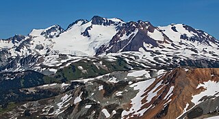
Overlord Mountain is a 2,625-metre (8,612-foot) glacier-clad peak located in the Garibaldi Ranges of the Coast Mountains, in Garibaldi Provincial Park of southwestern British Columbia, Canada. It is the highest point of the Fitzsimmons Range, which is a subset of the Garibaldi Ranges, and can be readily seen from the Whistler Blackcomb ski area. It is situated 15 km (9 mi) southeast of Whistler, and its nearest higher peak is Mount Macbeth, 3 km (2 mi) to the north-northeast. The Benvolio Glacier rests below the south aspect of the summit, the Fitzsimmons Glacier on the east aspect, and the expansive Overlord Glacier spans the northern and western aspects of the mountain. Precipitation runoff from the peak and meltwater from its glaciers drains into tributaries of the Cheakamus River. The first ascent of the mountain was made in 1923 by Phyllis Munday and Don Munday via the Benvolio Glacier. The mountain's descriptive name was recommended by the Garibaldi Park Board and officially adopted on September 2, 1930, by the Geographical Names Board of Canada.

