Related Research Articles

The Fraser Canyon is a major landform of the Fraser River where it descends rapidly through narrow rock gorges in the Coast Mountains en route from the Interior Plateau of British Columbia to the Fraser Valley. Colloquially, the term "Fraser Canyon" is often used to include the Thompson Canyon from Lytton to Ashcroft, since they form the same highway route which most people are familiar with, although it is actually reckoned to begin above Williams Lake at Soda Creek Canyon near the town of the same name.

The Bridge River is an approximately 120 kilometres (75 mi) long river in southern British Columbia. It flows south-east from the Coast Mountains. Until 1961, it was a major tributary of the Fraser River, entering that stream about six miles upstream from the town of Lillooet; its flow, however, was near-completely diverted into Seton Lake with the completion of the Bridge River Power Project, with the water now entering the Fraser just south of Lillooet as a result.
The Chilcotin region of British Columbia is usually known simply as "the Chilcotin", and also in speech commonly as "the Chilcotin Country" or simply Chilcotin. It is a plateau and mountain region in British Columbia on the inland lee of the Coast Mountains on the west side of the Fraser River. Chilcotin is also the name of the river draining that region. In the language of the Tsilhqot'in people, their name and the name of the river means "those of the red ochre river". The proper name of the Chilcotin Country, or Tsilhqotʼin territory, in their language is Tŝilhqotʼin Nen.

The Pacific Ranges are the southernmost subdivision of the Coast Mountains portion of the Pacific Cordillera. Located entirely within British Columbia, Canada, they run northwest from the lower stretches of the Fraser River to Bella Coola and Burke Channel, north of which are the Kitimat Ranges. The Coast Mountains lie between the Interior Plateau and the Coast of British Columbia.

The Chilcotin Ranges are a subdivision of the Pacific Ranges of the Coast Mountains. They lie on the inland lea of the Pacific Ranges, abutting the Interior Plateau of British Columbia. Their northwestern end is near the head of the Klinaklini River and their southeast end is the Fraser River just north of Lillooet; their northern flank is the edge of the Plateau while their southern is the north bank of the Bridge River. In some reckonings they do not go all the way to the Fraser but end at the Yalakom River, which is the North Fork of the Bridge.

The Shulaps Range is a subrange of the Chilcotin Ranges subset of the Pacific Ranges of the Coast Mountains in southwest-central British Columbia. The range is 55 km NW–SE and 15 km SW–NE and 2,970 km2 (1,150 sq mi) in area.

The Dickson Range is a subrange of the Chilcotin Ranges subset of the Pacific Ranges of the Coast Mountains in southwest-central British Columbia. It is located just west of the town of Gold Bridge between the valley of Slim Creek to the north and Downton Lake Reservoir to the south. At its eastern foot is Gun Lake; its western limit is at a pass between Slim Creek and Nichols Creek near the pass which separates the Bridge River basin from that of the Lord River, which feeds the Taseko Lakes.

The Camelsfoot Range is a sub-range of the Chilcotin Ranges subdivision of the Pacific Ranges of the Coast Mountains in British Columbia. The Fraser River forms its eastern boundary. The range is approximately 90 km at its maximum length and less than 30 km wide at its widest.

The Spruce Lake Protected Area, formerly known variously as the Southern Chilcotin Mountains Provincial Park, Southern Chilcotins, and also as South Chilcotin Provincial Park, is a 71,347-hectare Protected Area in the British Columbia provincial parks system, approximately 200 km north of Vancouver. The area had been the subject of an ongoing preservationist controversy since the 1930s. In 2007, its status as a provincial park was downgraded to protected area.
Tyaughton Lake, also known as Tyax Lake, is a lake in the Bridge River Country of the West-Central Interior of British Columbia, Canada, located to the north of Carpenter Lake, a reservoir along the Bridge River formed by Terzaghi Dam of the Bridge River Power Project. Among the largest of a number of well-known fishing lakes located in valleys flanking the Bridge River, its name is an adaptation of a Chilcotin word meaning "jumping fish". Around its shores is a community of recreational homes, and near its southern end had been an older fishing lodge, the Tyaughton Lake Lodge, while on its northwestern shore is the Tyax Mountain Lake Resort, built in the 1980s, which at the time of construction was the largest log structure built in British Columbia in the 20th Century. Despite the shared name, it is not directly on the course of Tyaughton Creek, but is linked to the lower canyon of that creek by a short intermediary stream. The main road access is from the Gun Creek Forest Service Road from a junction on BC Highway 40 (the Gold Bridge-Lillooet Road midway between the outlets into Carpenter Lake of Tyaughton Creek and Gun Creek.
Big Creek is a roughly 120-kilometre (75 mi) long tributary of British Columbia's Chilcotin River.

Gold Bridge is an unincorporated community in the Bridge River Country of British Columbia, Canada. Although numbering only around 40 inhabitants, Gold Bridge is the service and supply centre for the upper basin of the Bridge River Valley, which includes recreation-residential areas at the Gun Lakes, Tyaughton Lake, Marshall Creek, and Bralorne; and the nearby ghost towns of Brexton and Pioneer Mine.
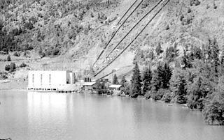
The Bridge River Power Project is a hydroelectric power development in the Canadian province of British Columbia, located in the Lillooet Country between Whistler and Lillooet. It harnesses the power of the Bridge River, a tributary of the Fraser, by diverting it through a mountainside to the separate drainage basin of Seton Lake, utilizing a system of three dams, four powerhouses and a canal.
The Bridge River Country is a historic geographic region and mining district in the Interior of British Columbia, Canada, lying between the Fraser Canyon and the valley of the Lillooet River, south of the Chilcotin Plateau and north of the Lillooet Ranges. "The Bridge River" can mean the Bridge River Country as opposed to the Bridge River itself, and is considered to be part of the Lillooet Country, but has a distinct history and identity within the larger region. As Lillooet is sometimes considered to be the southwest limit of the Cariboo, some efforts were made to refer to the Bridge River as the "West Cariboo" but this never caught on.

Bralorne is a historic Canadian gold mining community in the Bridge River District of British Columbia, some 130 km on dirt roads west of the town of Lillooet.

Churn Creek is a tributary of the Fraser River in the Canadian province of British Columbia.
Mission Ridge, also known as Mission Mountain, is a ridge in the Bridge River-Lillooet Country of the South-Central Interior of British Columbia, Canada, extending westward from the town of Lillooet along the north side of Seton Lake to Mission Pass, which is immediately above and to the north of the lakeside community of Shalalth. The road over the pass is also known as Mission Mountain, which is short for "Mission Mountain Road". Mission Creek lies on the north side of the pass, and is a tributary of the Bridge River, the lower reaches of which lie on the north side of the ridge, and which was the only road access into the upper Bridge River Country before the construction of a road through the Bridge River Canyon in the mid-1950s opened that region up to road access from the lower Bridge River valley and the town of Lillooet via the community of Moha. Most, or virtually all, of the ridge, is Indian Reserves, notably Slosh 1, under the administration of the Seton Lake Indian Band, and Bridge River 1, which is under the administration of the Bridge River Indian Band. Parts of the ridge's eastern end are in reserves controlled by the Lillooet Indian Band, including its final spires above Lillooet, which were dubbed St. Mary's Mount by the Reverend Lundin Brown in the 1860s, though that name never stuck and is ungazetted.
Tyoax Pass is a mountain pass in the Chilcotin Ranges of the Pacific Ranges, the southernmost main subdivision of the Coast Mountains of British Columbia, Canada. Located at the head of Tyaughton Creek, a north tributary of the Bridge River, it connects the basin of the Bridge River with that of Big Creek in the southern Chilcotin District, and is therefore at the boundary between the Spruce Lake Protected Area and Big Creek Provincial Park.
South Chilcotin Mountains Provincial Park is a provincial park in British Columbia, Canada, located on Highway 40 northwest of Lillooet, British Columbia. The park, which is 56,796 ha. in size, was established on April 18, 2001, and It was created out of a portion of the Spruce Lake Protected Area. The park is located on three Indigenous Nations: The Tsilhqot’in, St’at’imc, and Secwepemc.
The Lillooet Land District is one of the 59 cadastral subdivisions of British Columbia, which were created by the Lands Act of the Colony of British Columbia in 1859, defined as "a territorial division with legally defined boundaries for administrative purposes". The land district's boundaries came to be used as the boundary of the initial Lillooet riding for the provincial Legislature from 1871, when the colony became a province. In addition to use in descriptions of land titles and lot surveys, the Land District was also the basis of the Lillooet Mining District.
References
- ↑ "Tyaughton River". BC Geographical Names .
- ↑ "Tyaughton Creek". BC Geographical Names .
- ↑ Short Portage to Lillooet, Irene Edwards, self-publ., Lillooet, 1976, various editions
- ↑ The Great Years: Gold Mining in the Bridge River Country, Lewis Green, Tricouni Press, Vancouver, 2000