Chief Hunter Jack

Last updated

Hunter Jack of Shalalth inhabited the Bridge River Country region of southwestern British Columbia. He was a larger-than-life indigenous personality who died in 1905.

Contents

Character

His formal name was Jack Tashpola [1] [2] or Tash Poli. He was born at 22-Mile post. [3] He was called chief of D'Arcy, We Enkekti, or Hunter Jack. Folklore portrays him as the hero who negotiated peace among First Nations and toward Chinese miners, but was murdered by persons unknown. [4]

Contemporary newspaper accounts present a more complex character, who was commonly intoxicated. He would often threaten with violence anyone who crossed his path. [5] Whisky and gin were his preferred beverages. [6]

Hunting and trapping

Jack was a first-class big game hunter, who trapped and hunted in the Bridge River Country. [2] Renowned for storytelling, he would boast of hand-to-hand combat with wild animals. [7] He assisted guides who led trophy hunters to the Lillooet area. In the 1880s, he met visiting hunter Captain (later Admiral) Seymour, who was so impressed by Jack that he subsequently sent him a flag and naval uniform as gifts. Jack raised the flag in front of his cabin and wore the uniform on occasions. His colleagues did not question this self-titled status. [7] He exerted significant control over the meat sale business in the area. [3]

Mining

He was one of the most successful placer miners in the district. He never lived on the reserve but had a cabin near the confluence of the Hurley River. [6] He held potlatches at which he presented gold nuggets to his guests. Pointing his rifle to intimidate, he drove the Chinese miners from Marshall Creek and Tyaughton Creek. [7] Many believed Jack found most of his gold around the head of Tyax (Tyaughton) creek. [3]

In 1913, old and decayed sluice boxes were discovered at a site which was possibly where Jack once found impressive gold nuggets. [6] Alternative versions claim searches for the location were unsuccessful. [3] [6]

Deaths

In 1882, Hunter Jack was charged but not tried for the murder of the Poole family. Evidence pointed to other perpetrators. [1]

In 1900, when Jack found his daughter Julia Ann hanged, the official verdict was murder, but many suspected suicide. The girl, who had been missing for several days, had been drinking heavily for some time. [8]

In 1905, Jack and his son William drank gin freely while paddling a boat on Seton Lake. In rough water close to shore, each time Jack attempted to stand, he fell, striking his head on a section of the boat. Wading to shore, William dragged his father. On dry land, Jack drank more, while William built a fire. After warming himself at a residence about two miles away, William returned alone to find his father dead. Jack was about 70 years of age. The official verdict was death from excessive drinking and exposure. [2] He was buried at D’Arcy and his son Thomas Jack, succeeded him as hereditary chief. [3]

In 1907, William died of exposure while out trapping with his brother Johnnie. [9]

Ferry

In the late 1800s, Jack operated the first ferry across the upper Bridge River for a period. [10] For this toll operation, he used a canoe to carry passengers and supplies, but horses swam. [11]

In August 1898, Charles Mowson was awarded the ferry charter for a year. During the first 10 days, four horses drowned and several had narrow escapes. One horse being towed tried to board the boat, almost capsizing it. [12] Brother Thomas Mowson, who assisted in the venture, [13] took over when Charles died in a hunting accident the following February. [14] The charter renewed for a further five years, [15] a larger ferry was installed, which could also carry livestock. [16]

In April 1900, G.A. Ward purchased the T.R. Mowson ferry operation. [17] Two months later, when the cable broke, Ward jumped from the drifting ferry. The scow was destroyed by the raging torrent downriver. [18] After a month, a new scow was in operation. [19] The ferry received a government subsidy from 1905 [20] almost until service ended, [21] which occurred in 1910, when the Ward's Ferry bridge was built. [22] Sebring Creek [23] flowed into Bridge River about a mile above that bridge. [24]

When the Carpenter Lake reservoir for the Mission Dam filled in the 1950s, the remnants of the then Hanson's bridge floated away after a few years. [10]

Footnotes

  1. 1 2 "Correspondence: Arrest of Hunter Jack". library.ubc.ca. 1882. pp. 1–10.
  2. 1 2 3 "Prospector". library.ubc.ca. 25 May 1905. p. 4.
  3. 1 2 3 4 5 Edwards 1976, p. 162.
  4. Swoboda, Leo John (1971). Lillooet phonology, texts and dictionary. library.ubc.ca (MA). pp. 128–133 (121–126).
  5. "Prospector". library.ubc.ca. 12 Oct 1900. p. 1.
  6. 1 2 3 4 "Prospector". library.ubc.ca. 17 Oct 1913. p. 4.
  7. 1 2 3 Edwards 1976, p. 161.
  8. "Prospector". library.ubc.ca. 19 Oct 1900. p. 1.
  9. "Daily News". library.ubc.ca. 1 Mar 1907. p. 1.
  10. 1 2 Edwards 1976, p. 164.
  11. "Prospector". library.ubc.ca. 22 Jan 1915. p. 2.
  12. "Prospector". library.ubc.ca. 2 Sep 1898. p. 1.
  13. "Prospector". library.ubc.ca. 28 Oct 1898. p. 6.
  14. "Prospector". library.ubc.ca. 3 Mar 1899. p. 1.
  15. "Prospector". library.ubc.ca. 5 May 1899. p. 1.
  16. "Prospector". library.ubc.ca. 14 Jul 1899. p. 4.
  17. "Prospector". library.ubc.ca. 13 Apr 1900. p. 1.
  18. "Prospector". library.ubc.ca. 22 Jun 1900. p. 1.
  19. "Prospector". library.ubc.ca. 3 Aug 1900. p. 1.
  20. "Public Accounts, 1905–06". library.ubc.ca. p. 130 (B1345).
  21. "Public Accounts, 1907–08". library.ubc.ca. p. C140.
  22. "Minister of Public Works annual report, 1909–10". library.ubc.ca. p. H10.
  23. "Sebring Creek (creek)". BC Geographical Names .
  24. "Minister of Mines annual report, 1913". library.ubc.ca. p. 311 (K270).

Related Research Articles

<span class="mw-page-title-main">Lillooet</span> District municipality in British Columbia, Canada

Lillooet is a district municipality in the Squamish-Lillooet region of southwestern British Columbia. The town is on the west shore of the Fraser River immediately north of the Seton River mouth. On BC Highway 99, the locality is by road about 100 kilometres (62 mi) northeast of Pemberton, 64 kilometres (40 mi) northwest of Lytton, and 172 kilometres (107 mi) west of Kamloops.

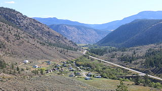
Shalalth and South Shalalth are unincorporated communities on the northern shore near the western end of Seton Lake in the Squamish-Lillooet region of southwestern British Columbia. The localities are by road about 63 kilometres (39 mi) northwest of Lillooet, but only 24 kilometres (15 mi) by rail.

<span class="mw-page-title-main">Canal Flats</span> Village in British Columbia, Canada

Canal Flats is a village municipality in the East Kootenay region of southeastern British Columbia. This Columbia Valley community lies between the southern end of Columbia Lake and the northwest shore of the Kootenay River. The locality, on Highway 93/95, is by road about 83 kilometres (52 mi) north of Cranbrook and 165 kilometres (103 mi) southeast of Golden.

<span class="mw-page-title-main">Seton Lake</span> Lake in British Columbia, Canada

Seton Lake is a lake in the Squamish-Lillooet region of southwestern British Columbia. On the northeast side is Mission Ridge. On the southwest is the Cayoosh Range. By road, the eastern end is about 7 kilometres (4.3 mi) southwest of Lillooet.

<span class="mw-page-title-main">Anderson Lake (British Columbia)</span> Body of water

Anderson Lake is a deep lake in the Squamish-Lillooet region of southwestern British Columbia. On the northwest side are the Bendor Range and Cadwallader Range. On the southeast is the Cayoosh Range. By road, the southern end is about 47 kilometres (29 mi) northeast of Pemberton.

Tyaughton Creek, formerly gazetted as the Tyaughton River, also historically known as Tyoax Creek, is a 50 kilometre tributary of British Columbia's Bridge River, flowing generally southeast to enter the main flow of that river about mid-way along the length of Carpenter Lake, a reservoir formed by Terzaghi Dam of the Bridge River Power Project.

Donald is an unincorporated community in the East Kootenay region of southeastern British Columbia. This almost ghost town is on the northeast shore of the Columbia River immediately southeast of the mouth of Marl Creek. The locality, on BC Highway 1, is by road about 28 kilometres (17 mi) northwest of Golden and 122 kilometres (76 mi) northeast of Revelstoke.

Alexandria or Fort Alexandria was a general area encompassing a trading post, ferry site, and steamboat landing in the North Cariboo region of central British Columbia. The present unincorporated community is on the eastern side of the Fraser River. On BC Highway 97, the locality is by road about 74 kilometres (46 mi) northwest of Williams Lake and 45 kilometres (28 mi) south of Quesnel.

<span class="mw-page-title-main">Pavilion, British Columbia</span> Ranching & Indian reserve community in British Columbia, Canada

Pavilion is an unincorporated community on the eastern side of the Fraser River in the South Cariboo region of southwestern British Columbia. The place is near Mile 21 of the Old Cariboo Road. On BC Highway 99, the locality is by road about 36 kilometres (22 mi) northeast of Lillooet and 135 kilometres (84 mi) west of Kamloops.

The Duncan River is in the West Kootenay region of southeastern British Columbia. Entering the North Arm of Kootenay Lake, the river is a major tributary of the Kootenay River, which in turn flows into the Columbia River. The Selkirk Mountains lie to the west and the Purcell Mountains to the east.

<span class="mw-page-title-main">Bralorne</span>

Bralorne is a historic Canadian gold mining community in the Bridge River District of British Columbia, some 130 km on dirt roads west of the town of Lillooet.

Fisherville is a ghost town on the northwest shore of the Wild Horse River in the East Kootenay region of southeastern British Columbia. The locality, off the Fort Steele-Wildhorse Road, is by road about 7 kilometres (4 mi) northeast of Fort Steele.

Danville is an unincorporated community and census-designated place (CDP) in Ferry County, Washington, United States. Danville is located on Washington State Route 21 near the Canada–United States border, 31 miles (50 km) north-northeast of Republic, the Ferry County seat.

Poplar Creek is a ghost town in the West Kootenay region of southeastern British Columbia. The former mining community is at the mouth of Popular Creek on the southwest side of the Lardeau River. The locality, on BC Highway 31, is about 37 kilometres (23 mi) northwest of Lardeau and 16 kilometres (10 mi) southeast of Gerrard.

Gold Hill or Goldhill is a ghost town in the West Kootenay region of southeastern British Columbia. The former mining community is on the northeast side of the Lardeau River. The locality, on BC Highway 31, is about 32 kilometres (20 mi) northwest of Lardeau and 21 kilometres (13 mi) southeast of Gerrard.

Parsonville is a ghost town on the east shore of the Fraser River approximately opposite Lillooet. On BC Highway 99, the locality is by road about 100 kilometres (62 mi) northeast of Pemberton, 64 kilometres (40 mi) northwest of Lytton, and 172 kilometres (107 mi) west of Kamloops.

Athalmer is an unincorporated community in the East Kootenay region of southeastern British Columbia. This place is primarily on the western shore of the Columbia River south of the mouth of Toby Creek. The locality, off the merged section of highways 93 and 95, is by road about 134 kilometres (83 mi) north of Cranbrook and 120 kilometres (75 mi) southeast of Golden.

<span class="mw-page-title-main">Danville–Carson Border Crossing</span> Border crossing between Canada and the United States

The Danville–Carson Border Crossing connects the town of Danville, Washington with Grand Forks, British Columbia on the Canada–US border. Washington State Route 21 on the American side joins British Columbia Highway 41 on the Canadian side.

A series of ferries and bridges have crossed the Fraser River in the vicinity of Lillooet in the Squamish-Lillooet region of southwestern British Columbia. From the 1850s, these crossings have connected both north–south and local traffic.

Shoreacres is an unincorporated community in the West Kootenay region of southeastern British Columbia. This former ferry landing lies on the northwest shore of the Kootenay River and northeast shore of the Slocan River. The location, on BC Highway 3A, is by road about 20 kilometres (12 mi) northeast of Castlegar, and 24 kilometres (15 mi) southwest of Nelson.

References