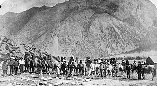
The Stʼatʼimc, also known as the Lillooet, St̓át̓imc, or Stl'atl'imx, are an Interior Salish people located in the southern Coast Mountains and Fraser Canyon region of the Interior of the Canadian province of British Columbia.

The following is an alphabetical list of articles related to the Canadian province of British Columbia.
Yale-Lillooet was a provincial electoral district for the Legislative Assembly of British Columbia, Canada.

The Fraser Canyon is a major landform of the Fraser River where it descends rapidly through narrow rock gorges in the Coast Mountains en route from the Interior Plateau of British Columbia to the Fraser Valley. Colloquially, the term "Fraser Canyon" is often used to include the Thompson Canyon from Lytton to Ashcroft, since they form the same highway route which most people are familiar with, although it is actually reckoned to begin above Williams Lake at Soda Creek Canyon near the town of the same name.
Cornwall Hills Provincial Park is a provincial park in British Columbia, Canada, immediately west of Cache Creek, protecting part of the Cornwall Hills including their highest summit which features an old fire lookout.

Marble Canyon Provincial Park is a provincial park in British Columbia, Canada, established in 1956 to protect Marble Canyon, a limestone formation at the south end of the Marble Range. In 2001 the park was expanded to 355 hectares to include all of Pavilion Lake due to the presence of microbialites, a type of stromatolite important to research into astrobiology and other fields, and in 2010, it was further expanded to 2,544 hectares.

The Secwépemc, known in English as the Shuswap peopleSHOOSH-wahp, are a First Nations people residing in the interior of the Canadian province of British Columbia. They speak one of the Salishan languages, known as Secwepemctsín or Shuswap.

Clinton is a village in British Columbia, Canada, located approximately 40 km (25 mi) northwest of Cache Creek and 30 km south of 70 Mile House.
Nicola, also Nkwala or N'kwala, was an important First Nations political figure in the fur trade era of the British Columbia Interior as well as into the colonial period (1858–1871). He was grand chief of the Okanagan people and chief of the Nicola Valley peoples, an alliance of Nlaka'pamux and Okanagans and the surviving Nicola Athapaskans, and also of the Kamloops Band of the Shuswap people.

The British Columbia Interior, popularly referred to as the BC Interior or simply the Interior, is a geographic region of the Canadian province of British Columbia. While the exact boundaries are variously defined, the British Columbia Interior is generally defined to include the 14 regional districts that do not have coastline along the Pacific Ocean or Salish Sea, and are not part of the Lower Mainland. Other boundaries may exclude parts of or even entire regional districts, or expand the definition to include the regional districts of Fraser Valley, Squamish–Lillooet, and Kitimat–Stikine.
The Shuswap Nation Tribal Council is a First Nations Tribal Council in the Canadian province of British Columbia. Based in the Thompson and Shuswap Districts of the Central Interior, although including one band on the upper Columbia River in the East Kootenay region. It is one of two tribal councils of the Secwepemc people, the other being the Northern Shuswap Tribal Council of the Cariboo region farther to the north. The council is based in Kamloops, British Columbia.

The Bonaparte Indian Band a.k.a. Bonaparte First Nation, is a member band of the Shuswap Nation Tribal Council of the Secwepemc (Shuswap) people.
The High Bar First Nation is a First Nations government of the Secwepemc (Shuswap) Nation, located in the Fraser Canyon-Cariboo region of the Central Interior of the Canadian province of British Columbia. It was created when the government of the then-Colony of British Columbia established an Indian reserve system in the 1860s. It is one of three Secwepemc bands that is not a member of either the Shuswap Nation Tribal Council or the Northern Shuswap Tribal Council. The High Bar people are also partly Tsilhqot'in and have links with some Chilcotin First Nations.
The Pavilion Indian Band or Ts'kw'aylaxw First Nation or Tsk'waylacw First Nation or Tsk'weylecw First Nation, and also known in the plural e.g. Ts'kw'alaxw First Nations, is a First Nations government, located in the Fraser Canyon region of the Central Interior of the Canadian province of British Columbia. It was created when the government of the then-Colony of British Columbia established an Indian reserve system in the 1860s.
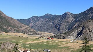
Fountain is an unincorporated rural area and Indian reserve community in the Fraser Canyon region of British Columbia, Canada, located at the ten-mile (16 km) mark from the town of Lillooet on BC Highway 99, which in that area is also on the route of the Old Cariboo Road and is located at the junction of that route with the old gold rush-era trail via Fountain Valley and the Fountain Lakes.

Pavilion Lake is a freshwater lake located in Marble Canyon, British Columbia, Canada home to colonies of freshwater microbialites.

Chimney Rock Statimc, is a limestone formation in Marble Canyon, midway between the towns of Lillooet and Cache Creek in British Columbia, Canada. It is located within Marble Canyon Provincial Park.

Cayoosh Creek is a northeast-flowing tributary of the Seton River in the Canadian province of British Columbia. The name Cayoosh Creek remains on the bridge-sign crossing the stream on BC Highway 99 and continues in use locally to refer to the final reaches of the Seton River, formerly Seton Creek, which prior to the renaming ending at the confluence with Cayoosh Creek. The creek is the namesake of Cayoosh Creek Indian Reserve No. 1, one of the main Indian reserves of the Cayoose Creek Indian Band, which lies adjacent to what was renamed the Seton River without local consultation.
Mission Ridge, also known as Mission Mountain, is a ridge in the Bridge River-Lillooet Country of the South-Central Interior of British Columbia, Canada, extending westward from the town of Lillooet along the north side of Seton Lake to Mission Pass, which is immediately above and to the north of the lakeside community of Shalalth. The road over the pass is also known as Mission Mountain, which is short for "Mission Mountain Road". Mission Creek lies on the north side of the pass, and is a tributary of the Bridge River, the lower reaches of which lie on the north side of the ridge, and which was the only road access into the upper Bridge River Country before the construction of a road through the Bridge River Canyon in the mid-1950s opened that region up to road access from the lower Bridge River valley and the town of Lillooet via the community of Moha. Most, or virtually all, of the ridge, is Indian Reserves, notably Slosh 1, under the administration of the Seton Lake Indian Band, and Bridge River 1, which is under the administration of the Bridge River Indian Band. Parts of the ridge's eastern end are in reserves controlled by the Lillooet Indian Band, including its final spires above Lillooet, which were dubbed St. Mary's Mount by the Reverend Lundin Brown in the 1860s, though that name never stuck and is ungazetted.
Marble Canyon 3, properly and most commonly referred to as Marble Canyon Indian Reserve No. 3, is an Indian reserve of the Ts’kw’aylaxw First Nation, located at the southeast end of Marble Canyon, adjacent to BC Highway 99 just northwest of the Upper Hat Creek junction, which is about midway between the towns of Lillooet and Cache Creek. The main reserve of the Tx'kw'ylaxw/Pavilion Band is Pavilion Indian Reserve No. 1, located at the community of Pavilion, which lies at the northwest end of Marble Canyon, which is to say at the opening of the valley of Pavilion Creek into the Fraser Canyon.


