
The Northwest Territories is a federal territory of Canada. At a land area of approximately 1,144,000 km2 (442,000 sq mi) and a 2016 census population of 41,790, it is the second-largest and the most populous of the three territories in Northern Canada. Its estimated population as of 2021 is 45,515. Yellowknife is the capital, most populous community, and only city in the territory; its population was 19,569 as of the 2016 census. It became the territorial capital in 1967, following recommendations by the Carrothers Commission.

Northern Canada, colloquially the North or the Territories, is the vast northernmost region of Canada variously defined by geography and politics. Politically, the term refers to the three territories of Canada: Yukon, Northwest Territories and Nunavut. This area covers about 48 per cent of Canada's total land area, but has less than 1 per cent of Canada's population.
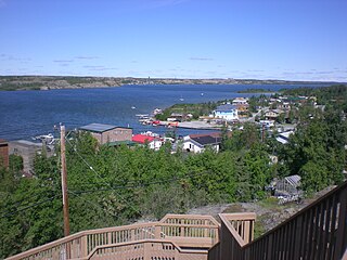
Yellowknife is the capital, largest community, and only city in the Northwest Territories, Canada. It is on the northern shore of Great Slave Lake, about 400 km (250 mi) south of the Arctic Circle, on the west side of Yellowknife Bay near the outlet of the Yellowknife River.

Great Slave Lake, known traditionally as Tıdeè in Tłı̨chǫ Yatıì, Tinde’e in Wıìlıìdeh Yatii / Tetsǫ́t’ıné Yatıé, Tu Nedhé in Dëne Sųłıné Yatıé, and Tucho in Dehcho Dene Zhatıé, is the second-largest lake in the Northwest Territories of Canada, the deepest lake in North America at 614 metres, and the tenth-largest lake in the world. It is 469 km (291 mi) long and 20 to 203 km wide. It covers an area of 27,200 km2 (10,502 sq mi) in the southern part of the territory. Its given volume ranges from 1,070 km3 (260 cu mi) to 1,580 km3 (380 cu mi) and up to 2,088 km3 (501 cu mi) making it the 10th or 12th largest by volume.

Enterprise is a hamlet in the South Slave Region of the Northwest Territories, Canada, located between Great Slave Lake and the Alberta border on the Hay River.
Kitikmeot Region is an administrative region of Nunavut, Canada. It consists of the southern and eastern parts of Victoria Island with the adjacent part of the mainland as far as the Boothia Peninsula, together with King William Island and the southern portion of Prince of Wales Island. The regional centre is Cambridge Bay.

Fort Smith is a town in the South Slave Region of the Northwest Territories (NWT), Canada. It is located in the southeastern portion of the Northwest Territories, on the Slave River and adjacent to the Northwest Territories/Alberta border.

Fort Resolution is a hamlet in the South Slave Region of the Northwest Territories, Canada. The community is situated at the mouth of the Slave River, on the shores of Great Slave Lake, and at the end of the Fort Resolution Highway. It is the headquarters of the Deninu Kųę́ First Nation, whose Chief is Louis Balsillie.

Franco-Ténois, originating from the acronym TNO, the French term for the Northwest Territories of Canada, refers to the widespread community of francophones who reside in the Northwest Territories.

Dettah, sometimes, incorrectly, as Detah, is a First Nations community in the North Slave Region of the Northwest Territories, Canada. Located just southeast of the capital of Yellowknife, it is a 6.5 km (4.0 mi) drive from that city by ice road across the north arm of Great Slave Lake in winter or a 27 km (17 mi) drive via the Ingraham Trail, year-round. The name means 'Burnt Point' in the Tli Cho language and refers to a traditional fishing camp used by the Dene for hundreds of years.

The Yellowknives, Yellow Knives, Copper Indians, Red Knives or T'atsaot'ine are indigenous peoples of Canada, one of the five main groups of the First Nations Dene who live in the Northwest Territories of Canada. The name, which is also the source for the later community of Yellowknife, derives from the colour of the tools made from copper deposits.

Łutselkʼe, also spelt Łutsel Kʼe, is a "designated authority" in the North Slave Region of the Northwest Territories, Canada. The community is located on the south shore near the eastern end of Great Slave Lake and until 1 July 1992, it was known as Snowdrift, as the community lies near the mouth of the Snowdrift River.

Wekweètì, officially the Tłı̨chǫ Community Government of Wekweètì is a community in the North Slave Region of the Northwest Territories, Canada. Wekweètì is a Tłı̨chǫ aboriginal community and is located 195 km (121 mi) north of Yellowknife. It has no year-round road access but does have a winter ice road connection; the majority of transportation to and from the community is through the Wekweètì Airport. Wekweètì is the closest community to the Ekati Diamond Mine on the border with Nunavut. Wekweètì is part of the Tlicho Government.

The history of the Northwest Territories covers the period from thousands of years ago to the present day. Prior to European colonization, the lands that encompass present-day Northwest Territories were inhabited for millennia by several First Nations. European explorers and fur traders began to explore the region since the late-16th century. By the 17th century, the British laid claim to both the North-Western Territory and Rupert's Land; and granted the Hudson's Bay Company a commercial fur trade monopoly over the latter region.
Fort Smith Region was a former Statistics Canada census division, one of two in the Northwest Territories, Canada. It was abolished in the 2011 census, along with the other census division of Inuvik Region, and the land area of the Northwest Territories was divided into new census divisions named Region 1, Region 2, Region 3, Region 4, Region 5, Region 6.

The Northwest Territories is a territory in Northern Canada, specifically in Northwestern Canada between Yukon Territory and Nunavut including part of Victoria Island, Melville Island, and other islands on the western Arctic Archipelago. Originally a much wider territory enclosing most of central and northern Canada, the Northwest Territories was created in 1870 from the Hudson's Bay Company's holdings that were sold to Canada from 1869-1870. In addition, Alberta and Saskatchewan were formed from the territory in 1905. In 1999, it was divided again: the eastern portion became the new territory of Nunavut. Yellowknife stands as its largest city and capital. It has a population of 42,800 and has an area of 532,643 sq mi (1,379,540 km2). The current territory lies west of Nunavut, north of latitude 60° north, and east of Yukon.

Highway 4, known as the Ingraham Trail, extends from Yellowknife, Northwest Territories to Tibbitt Lake, approximately 70 km (43 mi) east of Yellowknife. It was built in the mid-1960s as the first leg of a 'road to resources' with the original intention of encircling Great Slave Lake.
This timeline of Yellowknife history summarises key events in the history of Yellowknife, a city in the Northwest Territories, Canada.
The following outline is provided as an overview of and topical guide to the Northwest Territories:

