
Victoria Island is a large island in the Arctic Archipelago that straddles the boundary between Nunavut and the Northwest Territories of Canada. It is the eighth-largest island in the world, and at 217,291 km2 (83,897 sq mi)1 in area, it is Canada's second-largest island. It is nearly double the size of Newfoundland (111,390 km2 [43,010 sq mi]), and is slightly larger than the island of Great Britain (209,331 km2 [80,823 sq mi]) but smaller than Honshu (225,800 km2 [87,200 sq mi]). The western third of the island lies in the Inuvik Region of the Northwest Territories; the remainder is part of Nunavut's Kitikmeot Region. The population of 2,168 is divided between two settlements, the larger of which is Cambridge Bay (Nunavut) and the other Ulukhaktok.

Melville Island is an uninhabited member of the Queen Elizabeth Islands of the Arctic Archipelago. With an area of 42,149 km2 (16,274 sq mi), it is the 33rd largest island in the world and Canada's eighth largest island.

The Queen Elizabeth Islands are the northernmost cluster of islands in Canada's Arctic Archipelago, split between Nunavut and the Northwest Territories in Northern Canada. The Queen Elizabeth Islands contain approximately 14% of the global glacier and ice cap area. The southern islands are called the Parry Islands or Parry Archipelago.
Melville Island may refer to:
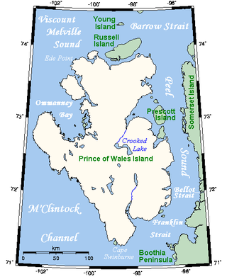
Prince of Wales Island is an Arctic island in Nunavut, Canada. One of the larger members of the Arctic Archipelago, it lies between Victoria Island and Somerset Island and is south of the Queen Elizabeth Islands.

A member of the Arctic Archipelago, Prince Patrick Island is the westernmost of the Queen Elizabeth Islands in the Northwest Territories of Canada, lying northwest of Melville Island. The area of Prince Patrick Island is 15,848 km2 (6,119 sq mi), making it the 55th largest island in the world and Canada's 14th largest island. It has historically been icebound all year, making it one of the least accessible parts of Canada. Located at the entrance of the M'Clure Strait, Prince Patrick Island is uninhabited.

Melville Island is an island in the eastern Timor Sea, off the coast of the Northern Territory, Australia. Along with Bathurst Island and nine smaller uninhabited islands, it forms part of the group known as the Tiwi Islands, which are under the jurisdiction of the Northern Territory in association with the Tiwi Land Council as the regional authority.

Melville Peninsula is a large peninsula in the Canadian Arctic north of Hudson Bay. To the east is Foxe Basin and to the west the Gulf of Boothia. To the north the Fury and Hecla Strait separates it from Baffin Island. To the south Repulse Bay and Frozen Strait separate it from Southampton Island at the north end of Hudson Bay. On the southwest it is connected to the mainland by the Rae Isthmus, named after the Arctic explorer John Rae.
Souris is a town in Kings County, Prince Edward Island, Canada. It is located near the northeastern tip of the province.

The Prince of Wales Strait is a strait in the Northwest Territories of Canada separating Banks Island to the northwest from Victoria Island to the southeast. It extends from Viscount Melville Sound in the northeast to Amundsen Gulf in the southwest. From late winter, it is filled by ice that usually does not break up until August, if at all. Its namesake, Prince of Wales Island, lies over 200 mi (320 km) to the east.

The locality Port Leopold is an abandoned trading post in the Qikiqtaaluk Region of Nunavut, Canada. It faces Prince Regent Inlet at the northeast tip of Somerset Island.
Dundas Island is a member of the Queen Elizabeth Islands and the Arctic Archipelago in the territory of Nunavut. It is an irregularly shaped island located between Devon Island and Baillie-Hamilton Island. The smaller Margaret Island is 1 km (0.62 mi) to the east of Dundas.
Dundas Island is an island on the North Coast of British Columbia, Canada, on the west side of Chatham Sound to the northwest of Prince Rupert. It is the largest of a group of islands known as the Dundas Islands.

Dundas Harbour is an abandoned settlement in the Qikiqtaaluk Region, Nunavut, Canada. It is located on Devon Island at the eastern shore of the waterway also named Dundas Harbour. Baffin Bay's Croker Bay is immediately to the west.
St. Peters Bay is a municipality that holds community status in Prince Edward Island, Canada. It was incorporated in 1953. St. Peters Bay is well known for its annual Blueberry Festival and Parade, which draws in tourists and locals alike.
