
Victoria Island is a large island in the Arctic Archipelago that straddles the boundary between Nunavut and the Northwest Territories of Canada. It is the eighth-largest island in the world, and at 217,291 km2 (83,897 sq mi) in area, it is Canada's second-largest island. It is nearly double the size of Newfoundland (111,390 km2 [43,010 sq mi]), and is slightly larger than the island of Great Britain (209,331 km2 [80,823 sq mi]) but smaller than Honshu (225,800 km2 [87,200 sq mi]). The western third of the island lies in the Inuvik Region of the Northwest Territories; the remainder is part of Nunavut's Kitikmeot Region. The population of 2,168 is divided among 2 settlements, the larger of which is in Nunavut and the other of which is in the Northwest Territories.

Somerset Island is a large, uninhabited island of the Arctic Archipelago, that is part of the Canadian territory of Nunavut. The island is separated from Cornwallis Island and Devon Island to the north by the Parry Channel, from Baffin Island to the east by Prince Regent Inlet, from the Boothia Peninsula to the south by Bellot Strait, and from Prince of Wales Island to the west by Peel Sound. It has an area of 24,786 km2 (9,570 sq mi), making it the 46th largest island in the world and Canada's twelfth largest island.

Thurston Island is an ice-covered, glacially dissected island, 215 km (134 mi) long, 90 km (56 mi) wide and 15,700 km2 (6,062 sq mi) in area, lying a short way off the northwest end of Ellsworth Land, Antarctica. It is the third-largest island of Antarctica, after Alexander Island and Berkner Island.

King William Island is an island in the Kitikmeot Region of Nunavut, which is part of the Arctic Archipelago. In area it is between 12,516 km2 (4,832 sq mi) and 13,111 km2 (5,062 sq mi) making it the 61st-largest island in the world and Canada's 15th-largest island. Its population, as of the 2021 census, was 1,349, all of whom live in the island's only community, Gjoa Haven.

Melville Peninsula is a large peninsula in the Canadian Arctic north of Hudson Bay. To the east is Foxe Basin and to the west the Gulf of Boothia. To the north the Fury and Hecla Strait separates it from Baffin Island. To the south Repulse Bay and Frozen Strait separate it from Southampton Island at the north end of Hudson Bay. On the southwest it is connected to the mainland by the Rae Isthmus, named after the Arctic explorer John Rae.

Boothia Peninsula is a large peninsula in Nunavut's northern Canadian Arctic, south of Somerset Island. The northern part, Murchison Promontory, is the northernmost point of mainland Canada.

Jervis Inlet is one of the principal inlets of the British Columbia Coast, about 95 km (59 mi) northwest of Vancouver, and the third of such inlets north of the 49th parallel, the first of which is Burrard Inlet, Vancouver's harbour.

The Prince of Wales Strait is a strait in the Northwest Territories of Canada separating Banks Island to the northwest from Victoria Island to the southeast. It extends from Viscount Melville Sound in the northeast to Amundsen Gulf in the southwest. From late winter it is filled by ice that usually does not break up until August, if at all. Its namesake, Prince of Wales Island, lies over 200 mi (320 km) to the east.

The Gulf of Boothia is a body of water in Nunavut, Canada. Administratively it is divided between the Kitikmeot Region on the west and the Qikiqtaaluk Region on the east. It merges north into Prince Regent Inlet, the two forming a single bay with different names for its parts. It is surrounded by, clockwise, Baffin Island, Fury and Hecla Strait, the Melville Peninsula, the Canadian mainland, and the Boothia Peninsula. The south end is Committee Bay, northwest of which are the Simpson Peninsula and Pelly Bay.

Prince Regent Inlet is a body of water in Nunavut, Canada between the west end of Baffin Island and Somerset Island on the west. It opens north into Lancaster Sound and to the south merges into the Gulf of Boothia. The Arctic inlet's northern portion is approximately 40 mi (64 km) wide; the southern portion is approximately 65 mi (105 km) wide. It is deep throughout and there are no islands within the inlet.

The Brodeur Peninsula is an uninhabited headland on Baffin Island in the Qikiqtaaluk Region of Nunavut, Canada. It is located in the northwestern part of the island and is bounded by Prince Regent Inlet to the west, Lancaster Sound to the north, and Admiralty Inlet to the east. The peninsula is connected to the rest of Baffin Island by a narrow isthmus to the south.
Bodie Island is a long, narrow barrier peninsula that forms the northernmost portion of the Outer Banks. The land that is most commonly referred to as Bodie Island was at one time a true island, but in 1811 Roanoke Inlet, which had separated it from the Currituck Banks in the north, closed. As a result, the Currituck Banks and Bodie Island are now one contiguous peninsula, joined at the Nags Head area, where the inlet once flowed. Today, either name can be used to refer to peninsula as a whole, but both portions colloquially retain their historical names.

The Parry Channel is a natural waterway through the central Canadian Arctic Archipelago. Its eastern two-thirds lie in the territory of Nunavut, while its western third lies in the Northwest Territories. It runs east to west, connecting Baffin Bay in the east with the Beaufort Sea in the west. Its eastern end is the only practical entrance to the Northwest Passage. Its western end would be a natural exit from the archipelago were it not filled with ice. The channel separates the Queen Elizabeth Islands to the north from the rest of Nunavut.
Minto Inlet is located east of Amundsen Gulf in western Victoria Island, at the southern end of Prince of Wales Strait in the Northwest Territories. It is 75 mi (121 km) long and between 8–25 mi (13–40 km) wide.
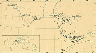
Prince Albert Sound is a Northern Canadian body of water located in the Inuvik Region of southwestern Victoria Island, Northwest Territories. It is an inlet of Amundsen Gulf. The sound separates the Wollaston Peninsula from the island's central areas. On 14 May 1851, some of Robert McClure's men reached its north side. Ten days later, John Rae (explorer) reached its south side, but the two groups had no contact.
Walker Bay is a Canadian Arctic waterway in the Northwest Territories. It is an eastern arm of Amundsen Gulf. The bay is located on western Victoria Island, between Jago Bay, in the north, and Minto Inlet, in the south. It is at the south entrance of Prince of Wales Strait. Fort Collinson is on the bay's northern shore.
Richard Collinson Inlet is a large inlet on the north side of Victoria Island, Northwest Territories, Canada. It opens into Viscount Melville Sound to the north. It is named after Richard Collinson, a Royal Navy officer and Arctic explorer. It should not be confused with the similarly named Collinson Inlet on King William Island.
Wynniatt Bay is an Arctic waterway and large inlet on the north side of Victoria Island, Canada, between the Richard Collinson Inlet and Hadley Bay. Most of the bay is in the Northwest Territories, but its eastern extremities are in the Kitikmeot Region of Nunavut. The bay opens into Viscount Melville Sound to the north.
Fort Collinson was a trading post operated by the Hudson's Bay Company located on Victoria Island in the Northwest Territories, Canada. It is situated on the Prince Albert Peninsula on the north side of Walker Bay, just north of Minto Inlet.
Drury inlet is an inlet in the Queen Charlotte Strait region of the Central Coast of British Columbia, Canada, extending west from Wells Passage to the northwest of North Broughton Island, northwest of the town of Port Hardy. Branching off to the northeast from the north side of the head of the inlet is Actaeon Sound.
