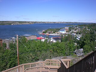
Yellowknife is the capital, largest community, and only city in the Northwest Territories, Canada. It is on the northern shore of Great Slave Lake, about 400 km (250 mi) south of the Arctic Circle, on the west side of Yellowknife Bay near the outlet of the Yellowknife River.

Agnico Eagle Mines Limited is a Canadian-based gold producer with operations in Canada, Finland, Australia and Mexico and exploration and development activities extending to the United States. Agnico Eagle has full exposure to higher gold prices consistent with its policy of no-forward gold sales. It has paid a cash dividend every year since 1983.
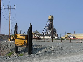
The Giant Mine was a gold mine located on the Ingraham Trail, 5 km (3.1 mi) north of Yellowknife, Northwest Territories. Giant Mine was within the Kam Group, a part of the Yellowknife greenstone belt. Gold was discovered on the property and mineral claims staked in 1935 by Johnny Baker, but the true extent of the gold deposits was not known until 1944, when a massive gold-bearing shear zone was uncovered beneath the drift-filled Baker Creek Valley.
Royal Oak Mines Incorporated was a gold mining company, founded in 1990 by Margaret "Peggy" Witte in Kirkland, Washington.
The Ptarmigan and Tom Mine were gold producers located in the Northwest Territories, Canada at Yellowknife. The property was staked by prospectors in 1936 and acquired by Cominco in 1938. The mine first produced between 1941 and 1942 but closed due to wartime restrictions. The old property was demolished in 1969–1970. A new company, Treminco Resources Limited, reopened the workings in 1985 and production from the Tom portal began in 1986 with material being trucked to Giant Mine. The old Ptarmigan mine shaft was dewatered and production began in 1987. A new mill was built at the property and was operational in July 1989. Low gold prices forced the company to close the mines in 1997. Total gold production has been approximately 120,000 troy ounces.

Teck Resources Limited, known as Teck Cominco until late 2008, is a diversified natural resources company headquartered in Vancouver, British Columbia, that is engaged in mining and mineral development, including coal for the steelmaking industry, copper, zinc, and energy. Secondary products include lead, silver, gold, molybdenum, germanium, indium and cadmium. Teck Resources was formed from the amalgamation of Teck and Cominco in 2001.
Negus Mine was a gold producer at Yellowknife, Northwest Territories, Canada, from 1939 to 1952. It produced 255,807 troy ounces (7,956.5 kg) of gold from 490,808 tons of ore milled. The underground workings were acquired by adjacent Con Mine in 1953 and were used for ventilation purposes until Con Mine closed in 2003.
The Burwash Mine was a small gold property discovered in the fall of 1934 by Johnny Baker and Hugh Muir at Yellowknife Bay, Northwest Territories. The town of Yellowknife did not exist yet at that point, but the discovery of gold at Burwash was the catalyst that brought more gold prospectors into the region in 1935 and 1936. A short shaft was sunk in 1935–1936 at Burwash, and in the summer of 1935 a 16-ton bulk sample of ore was shipped to Trail, British Columbia for processing, yielding 200 troy ounces (6.2 kg) of gold. The mine did not become a substantial producer and it is believed the gold vein was mined out.
The Thompson-Lundmark Mine was a gold producer in the periods 1941–1943 and 1947–1949, near Yellowknife, Northwest Territories. Gold was discovered here in 1938 by Fred W. Thompson and Roy Lundmark, who staked 46 claims which were incorporated into the mine. Underground and shaft work began in 1939. The mine processed 133,989 tons of ore to produce 70,339 troy ounces (2,187.8 kg) of gold and 13,782 troy ounces (428.7 kg) of silver. The abandoned site was destroyed by forest fires during 1998.
The Discovery Mine was a gold mine 84 kilometers northeast of Yellowknife, Northwest Territories that operated between 1950 and 1969. Gold was discovered here by Alfred Giauque in 1944. A complete townsite, on Giauque Lake, was established by the company to house workers and their families. The mine produced one million troy ounces (31,000 kg) of gold from one million tons of ore. The abandoned townsite, not accessible by road, was demolished in 2005.
The Camlaren Mine was a small gold mine 80 km (50 mi) north-east of Yellowknife, Northwest Territories, Canada at Gordon Lake. It consists of a property totaling about 981 hectares. The two claims that make up the property were staked in 1936 by prospectors Don Cameron and the Mclaren brothers and developed with two shafts during 1937–1938. The name "Camlaren" is a portmanteau of Cameron and McLaren. Conditions attributed to World War II halted development at Camlaren in 1939.
The Pine Point Mine is located on the south shore of Great Slave Lake between Hay River to the west and Fort Resolution to the east, in the Northwest Territories of Canada. It produced lead and zinc ores from a Mississippi Valley Type deposit between 1964 and 1988. Most of the mining was done by open-pit methods. The town of Pine Point was built by the mining company, Cominco, and when the mine closed the town was abandoned and demolished.

Shaft mining or shaft sinking is the action of excavating a mine shaft from the top down, where there is initially no access to the bottom. Shallow shafts, typically sunk for civil engineering projects, differ greatly in execution method from deep shafts, typically sunk for mining projects.

The McIntyre mine is an abandoned underground gold mine in Schumacher, Ontario, Canada, which has earned a place in Canadian mining history as one of the nation's most important mines. Its iconic headframe, located near downtown Timmins, has come to represent the entire Porcupine Gold Rush. The McIntyre also yielded a considerable amount of copper over its life.

A headframe is the structure above an underground mine shaft, built for hoisting machines, people, and materials.
Neil Campbell FRSC was a Canadian geologist, and is a notable within the Canadian Mining Hall of Fame.
This timeline of Yellowknife history summarises key events in the history of Yellowknife, a city in the Northwest Territories, Canada.
Polaris zinc mine was a former underground mine on Little Cornwallis Island in the Canadian territory of Nunavut. The zinc mine was located 1,120 km (700 mi) north of the Arctic Circle, and 96 km (60 mi) north of the community of Resolute. It closed in July 2002 following more than twenty years of zinc production.

Ravenswood Mining Landscape and Chinese Settlement Area is a heritage-listed former mining town and archaeological site on the reserve bounded by School Street, Cemetery Road, Railway Street and Burdekin Falls Dam Road, Ravenswood, Charters Towers Region, Queensland, Australia. It was added to the Queensland Heritage Register on 14 October 2016.

