The Kam Group is a 10 km (6 mi) thick Archean volcanic group in the Yellowknife greenstone belt of the Northwest Territories, Canada. It consists of tholeiitic mafic and subordinate felsic volcanic rocks that were erupted in a submarine environment about 2706 million years ago.
The Archean Eon is one of the four geologic eons of Earth history, occurring 4,000 to 2,500 million years ago. During the Archean, the Earth's crust had cooled enough to allow the formation of continents and life started to form.
A volcanic group is a collection of related volcanoes or volcanic landforms. The term is also used in a different sense when it denotes a suite of associated rock strata largely of volcanic origin; see group (stratigraphy) for details.
The Yellowknife greenstone belt, also called the Yellowknife Volcanic Belt, is an Archean greenstone belt in the southern Slave craton, Northwest Territories, Canada. It is mostly made of mafic volcanic rocks and is bordered to the east by batholithic intrusions of the Western Granodiorite Complex and beyond to the north by the Duckfish Lake Granite. Intrusive equivalents are collectively known as the Kam Group. Most of the Yellowknife townsite and the Con and Giant gold mines are within the Kam Group. The Yellowknife greenstone belt stands out as a positive topographic feature.
Greenstone may refer to:
Greenstone belts are zones of variably metamorphosed mafic to ultramafic volcanic sequences with associated sedimentary rocks that occur within Archaean and Proterozoic cratons between granite and gneiss bodies.

The Slave Craton is an Archaean craton in the north-western Canadian Shield, in Northwest Territories and Nunavut. The Slave Craton includes the 4.03 Ga-old Acasta Gneiss which is one of the oldest dated rocks on Earth. Covering about 300,000 km2 (120,000 sq mi), it is a relatively small but well-exposed craton dominated by ~2.73–2.63 Ga greenstones and turbidite sequences and ~2.72–2.58 Ga plutonic rocks, with large parts of the craton underlain by older gneiss and granitoid units. The Slave Craton is one of the blocks that compose the Precambrian core of North America, also known as the palaeocontinent Laurentia.

Volcanology of Canada includes lava flows, lava plateaus, lava domes, cinder cones, stratovolcanoes, shield volcanoes, submarine volcanoes, calderas, diatremes, and maars, along with examples of more less common volcanic forms such as tuyas and subglacial mounds. It has a very complex volcanological history spanning from the Precambrian eon at least 3.11 billion years ago when this part of the North American continent began to form.
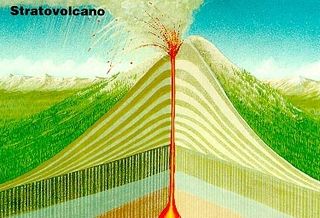
The Back River volcanic complex is an Archean stratovolcano spanning the Northwest Territories–Nunavut border in Northern Canada. It is located 480 kilometres (298 mi) northwest of Yellowknife and to the northwest of the Back River from which it takes its name. The volcano constitutes the Back Group of the Yellowknife Supergroup and is somewhat anomalous in the Slave craton because it has undergone only a low degree of deformation and is subhorizontal. The southern half of the complex is exposed at the crest of a small dome. This is the eroded portion of the stratovolcano that has been preserved in an upright position. The complex comprises four volcanic sedimentary sequences that correspond to the phases of growth and destruction of this stratovolcano.
The Lac des Vents volcanic complex is a 2.3 km (1.4 mi) thick Archean volcanic complex in the Abitibi greenstone belt of Quebec, Canada. It is an important part of a major submarine volcanic structure.
The Abitibi greenstone belt is a 2,800-to-2,600-million-year-old greenstone belt that spans across the Ontario–Quebec border in Canada. It is mostly made of volcanic rocks, but also includes ultramafic rocks, mafic intrusions, granitoid rocks, and early and middle Precambrian sediments.
The Bird River greenstone belt is an Archean greenstone belt in southeastern Manitoba, Canada.
The Swayze greenstone belt is a late Archean greenstone belt in northern Ontario, Canada. It is the southwestern extension of the Abitibi greenstone belt.

The Hope Bay greenstone belt, also called the Hope Bay volcanic belt, is a 42 km (26 mi) long Archean greenstone belt in western Nunavut, Canada. It consists of mostly mafic volcanic rocks and contains three major gold deposits called Boston, Doris and Naartok.
The Red Lake greenstone belt is an Archean greenstone belt at the town of Red Lake in Northwestern Ontario, Canada. It consists of basaltic and komatiitic volcanics ranging in age from 2,925 to 2,940 million years old and younger rhyolite-andesite volcanics ranging in age from 2,730 to 2,750 million years old.
The Rattlesnake Hills greenstone belt represents a fragment of a partially exposed synformal Archean greenstone belt within the Wyoming craton that was intruded by Cenozoic alkalic volcanics. The supracrustal belt has been subjected to multiphase deformation during the Archean and later brittle deformation during the Laramide orogeny. Ductile deformation during the Archean produced foliation, and at least three episodes of folding.

The volcanology of Eastern Canada includes the hundreds of volcanic areas and extensive lava formations in Eastern Canada. The region's different volcano and lava types originate from different tectonic settings and types of volcanic eruptions, ranging from passive lava eruptions to violent explosive eruptions. Eastern Canada has very large volumes of magmatic rock called large igneous provinces. They are represented by deep-level plumbing systems consisting of giant dike swarms, sill provinces and layered intrusions. The most capable large igneous provinces in Eastern Canada are Archean age greenstone belts containing a rare volcanic rock called komatiite.
Volcanology of Western Canada includes lava flows, lava plateaus, lava domes, cinder cones, stratovolcanoes, shield volcanoes, greenstone belts, submarine volcanoes, calderas, diatremes and maars, along with examples of more less common volcanic forms such as tuyas and subglacial mounds.

The Algoman orogeny, known as the Kenoran orogeny in Canada, was an episode of mountain-building (orogeny) during the Late Archean Eon that involved repeated episodes of continental collisions, compressions and subductions. The Superior province and the Minnesota River Valley terrane collided about 2,700 to 2,500 million years ago. The collision folded the Earth's crust and produced enough heat and pressure to metamorphose the rock. Blocks were added to the Superior province along a 1,200 km (750 mi) boundary that stretches from present-day eastern South Dakota into the Lake Huron area. The Algoman orogeny brought the Archaen Eon to a close, about 2,500 million years ago; it lasted less than 100 million years and marks a major change in the development of the earth’s crust.
The Sherman volcano is a possible prehistoric volcano in the municipality of Temagami in Northeastern Ontario, Canada. Geological evidence indicates that it was located west of the abandoned Sherman Mine and lies in the Archean Temagami Greenstone Belt.

The Barberton greenstone belt (BGB) is located in the Kapvaal craton of southeastern Africa. It characterizes one of the most well-preserved and oldest pieces of continental crust today by containing rocks in the Barberton Granite Greenstone Terrain (3.55–3.22 Ga). The BGB is a small, cusp-shaped succession of volcanic and sedimentary rocks, surrounded on all sides by granitoid plutons which range in age from >3547 to <3225 Ma. It is commonly known as the type locality of the ultramafic, extrusive volcanic rock, the komatiite. Greenstone belts are geologic regions generally composed of mafic to ultramafic volcanic sequences that have undergone metamorphism. These belts are associated with sedimentary rocks that occur within Archean and Proterozoic cratons between granitic bodies. Their name is derived from the green hue that comes from the metamorphic minerals associated with the mafic rocks. These regions are theorized to have formed at ancient oceanic spreading centers and island arcs. In simple terms, greenstone belts are described as metamorphosed volcanic belts. Being one of the few most well-preserved Archean portions of the crust, with Archean felsic volcanic rocks, the BGB is well studied. It provides present geologic evidence of Earth during the Archean (pre-3.0 Ga). Despite the BGB being a well studied area, its tectonic evolution has been the cause of much debate.

Archean felsic volcanic rocks are felsic volcanic rocks that were formed in the Archean Eon. The term "felsic" means that the rocks have silica content of 62–78%. Given that the Earth formed at ~4.5 billion year ago, Archean felsic volcanic rocks provide clues on the Earth's first volcanic activities on the Earth's surface started 500 million years after the Earth's formation.
The geology of Nunavut began to form nearly three billion years ago in the Archean and the territory preserves some of the world's oldest rock units.
| This Canadian Northwest Territories location article is a stub. You can help Wikipedia by expanding it. |
| This article about a specific Canadian geological feature is a stub. You can help Wikipedia by expanding it. |