Kalawao County, Hawaii

Last updated

Kalawao County
Kalaupapa penninsula.jpg
Kalaupapa peninsula
Map of Hawaii highlighting Kalawao County.svg
Location within the U.S. state of Hawaii
Hawaii in United States.svg
Hawaii's location within the U.S.
Coordinates: 21°11′49″N156°58′02″W / 21.196944444444°N 156.96722222222°W / 21.196944444444; -156.96722222222
CountryFlag of the United States.svg United States
StateFlag of Hawaii.svg  Hawaii
Founded1905
Named for Kalawao
Seat none (administered by Hawaii Dept. of Health)
Largest community Kalaupapa
Area
  Total53 sq mi (140 km2)
  Land12 sq mi (30 km2)
  Water41 sq mi (110 km2)  77.3%
Population
 (2020)
  Total82
  Density1.5/sq mi (0.60/km2)
Time zone UTC−10 (Hawaii–Aleutian)
Congressional district 2nd
Kalawao County, Hawaii
Interactive map of Kalawao County, Hawaii

Kalawao County (Hawaiian : Kalana o Kalawao) is a county in the U.S. state of Hawaii. [1] It is the smallest county in the 50 states by land area and the second-smallest county by population, after Loving County, Texas. [2] The county encompasses the Kalaupapa or Makanalua Peninsula, on the north coast of the island of Molokaʻi. The small peninsula is isolated from the rest of Molokaʻi by cliffs over a quarter-mile high; the only land access is a mule trail. [3]

Contents

Because of the small population (82 as of the 2020 United States Census [4] ), Kalawao County does not have the same functions as other Hawaii counties. Instead, it is a judicial district of Maui County, which includes the rest of the island of Molokaʻi. The county has no elected government. [5]

It was developed and used from 1866 to 1969 for settlements for treatment of quarantined persons with Hansen's disease (leprosy). [6]

History

The Kingdom of Hawaiʻi, the Republic of Hawaiʻi, the Territory of Hawaii, and the state of Hawaii all exiled persons suffering from Hansen's disease (leprosy) to the peninsula, from 1866 to 1969. The quarantine policy was only lifted after effective antibiotic treatments were developed that could be administered on an outpatient basis and patients could be rendered non-contagious. [7]

Many of the residents nonetheless chose to remain on the peninsula, as they believed their disfigurements from the illness would make reintegration into society impossible. The state promised that they could live there for the rest of their lives. No new patients, or other permanent residents, were later admitted. Visitors are permitted only as part of official tours. State law prohibits anyone under the age of 16 from visiting or living there, although exceptions have been made for children visiting their relatives.[ citation needed ]

In 1980, the Kalaupapa National Historical Park was established to preserve the county's history and environment. It is coterminous with the boundaries of Kalawao County.

Government

Kalawao County lacks a local, county government. Instead, Kalawao County is administered by the Hawaii Department of Health because of the history of the settlement and current patients living there. Under Hawaiian state law, the Director of the Hawaii Department of Health, who is appointed by the Governor, also serves as the Mayor of Kalawao County. [8] [9] [10] [11] The Mayor holds executive powers within the county; the mayor also appoints a county sheriff, who is selected from local residents. [12] The only county statutes that apply to Kalawao County directly are those on matters of health. [13]

Kalawao is part of the First Judicial Circuit, which includes the entire island of Oahu. [14] For the purpose of notarization, the designated venue for the First Judicial Circuit is "State of Hawaii, City and County of Honolulu."

Geography

According to the U.S. Census Bureau, the county has a total area of 53 square miles (140 km2), comprising 12 square miles (31 km2) of land and 41 square miles (110 km2) (77.3%) of water. [15] By land area, it is the smallest true county in the United States; some independent cities in Virginia are smaller and are sometimes considered to be "county equivalents" for statistical purposes such as with the US Census Bureau.

Kalaupapa Peninsula

Kalaupapa Peninsula contains the county's only settlement, Kalaupapa. The Kalaupapa Peninsula developed from lava that erupted from the ocean floor near Kauhakō Crater and spread outward, forming a low shield volcano. This was the most recent volcanic episode on the island and of the larger East Molokaʻi shield volcano, occurring after the formation of the cliffs by erosion.

Subdivisions

Kalawao County is composed of four ahupuaʻa. From west to east: [16] [17]

AhupuaʻaArea
mi2
Area
km2
PopulationDescription
Kalaupapa 2.0795.38565West side of Kalaupapa peninsula. Includes a section of Molokaʻi's coast further west
Makanalua 3.2298.3638Strip of land in the center of the peninsula that runs to its northern tip. Includes Kalaupapa Airport.
Kalawao 3.2948.5319Eastern coast of Kalaupapa peninsula and Waialeia Valley to the southeast
Waikolu 5.54414.3590Includes namesake valley. Uninhabited. [18]
Kalawao County14.14636.63882

Demographics

Historical population
CensusPop.Note
1900 1,177
1910 785−33.3%
1920 667−15.0%
1930 605−9.3%
1940 446−26.3%
1950 340−23.8%
1960 279−17.9%
1970 172−38.4%
1980 144−16.3%
1990 130−9.7%
2000 14713.1%
2010 90−38.8%
2020 82−8.9%
2023 (est.)81 [19] −1.2%
U.S. Decennial Census [20]
1790-1960 [21] 1900–1990 [22]
1990–2000 [23] 2010–2018 [24]

As of the census of 2000, [25] 147 people, 115 households, and 21 families resided in the county, declining to 90 inhabitants in 2010. The population density was 11 people per square mile (4.2 people/km2). The 172 housing units produced an average density of 13 per square mile (5.0/km2). The racial makeup of the county was 48% Pacific Islander, 26% White, 17% Asian, 3% from other races, and 6% from two or more races. Hispanic or Latino of any race made up 4%. Kalawao County has the highest Pacific Islander population percentage of any U.S. county, and is the only county where they make up a plurality.

2% of households housed children under the age of 18. 17% were married couples living together. 3% had a female householder with no husband present. 81% were non-families. 79% of all households were made up of individuals, and 31% had someone living alone who was 65 years of age or older. The average household size was 1.28 and the average family size was 2.27.

2% of residents were under the age of 18, 1% from 18 to 24, 18% from 25 to 44, 46% from 45 to 64, and 32% who were 65 years of age or older. The median age was 59 years. For every 100 females, there were 98.6 males. The population has declined since 1900: [26]

Kalawao County, Hawaii

Current residents include 16 former patients, [27] 40 federal employees who work on preservation projects, and some state-employed health workers. [28]

Transportation

The only access to Kalawao County is by air, or by a steep mule trail that descends 1,600 ft (490 m) from the rest of Molokaʻi. Kalaupapa Airport has scheduled air service to Molokaʻi Airport and to Honolulu Airport.

Freight is delivered to the county once a year, usually in July, by barge. [29]

Politics

United States presidential election results for Kalawao County, Hawaii [30]
Year Republican Democratic Third party
No.%No.%No.%
2020 14.17%2395.83%00.00%
2016 15.00%1470.00%525.00%
2012 27.41%2592.59%00.00%
2008 619.35%2477.42%13.23%
2004 1435.00%2665.00%00.00%
2000 1124.44%3066.67%48.89%
1996 1320.63%4673.02%46.35%
1992 2432.00%4864.00%34.00%

Like the rest of the state, Kalawao County is a stronghold for the Democratic Party. It was the only county in the United States where the Republican candidate in the 2016 United States presidential election, Donald Trump, finished in third by only getting one vote; 70% of Kalawao's voters chose Democratic nominee Hillary Clinton, and 25% of Kalawao voters cast their ballots for Green Party candidate Jill Stein, making it Stein's strongest county nationwide in terms of vote percentage. [31] In 2020 Joe Biden improved on Clinton's 2016 performance by over 25% as the Greens declined to zero votes, giving Biden 96% of the vote, which was his strongest performance in any county in the United States.

Education

The county is within the Hawaii Department of Education school district. [32]

Related Research Articles

<span class="mw-page-title-main">Hawaii</span> U.S. state

Hawaii is an island state of the United States, in the Pacific Ocean about 2,000 miles (3,200 km) southwest of the U.S. mainland. It is the only state not on the North American mainland, the only state that is an archipelago, and the only state in the tropics.

<span class="mw-page-title-main">Father Damien</span> Belgian Roman Catholic priest and saint (1840–1889)

Father Damien or Saint Damien of Molokai, SS.CC. or Saint Damien De Veuster, born Jozef De Veuster, was a Roman Catholic priest from Belgium and member of the Congregation of the Sacred Hearts of Jesus and Mary, a missionary religious institute. He was recognized for his ministry, which he led from 1873 until his death in 1889, in the Kingdom of Hawaiʻi to people with leprosy, who lived in government-mandated medical quarantine in a settlement on the Kalaupapa Peninsula of Molokaʻi.

<span class="mw-page-title-main">Maui County, Hawaii</span> County in Hawaii, United States

Maui County, officially the County of Maui, is a county in the U.S. state of Hawaii. It consists of the islands of Maui, Lānaʻi, Molokaʻi, Kahoʻolawe, and Molokini. The latter two are uninhabited. As of the 2020 census, the population was 164,754. The county seat is Wailuku.

<span class="mw-page-title-main">Molokai</span> Island of the Hawaiian Islands archipelago

Molokai is the fifth most populated of the eight major islands that make up the Hawaiian Islands archipelago in the middle of the Pacific Ocean. It is 38 by 10 miles at its greatest length and width with a usable land area of 260 sq mi (673.40 km2), making it the fifth-largest in size of the main Hawaiian Islands and the 27th largest island in the United States. It lies southeast of Oʻahu across the 25 mi (40 km) wide Kaʻiwi Channel and north of Lānaʻi, separated from it by the Kalohi Channel.

<span class="mw-page-title-main">Kalaupapa Airport</span> Airport

Kalaupapa Airport is a regional public use airport of the state of Hawaii, located on the northern peninsula of the island of Molokaʻi, two nautical miles north of Kalaupapa Settlement, in Kalawao County. Most flights to Kalaupapa originate from Molokai Airport or from airports on the other Hawaiian islands by unscheduled air taxis and general aviation. It is also used as a cargo facility carrying goods for Kalaupapa, which has no road access from the rest of Molokai.
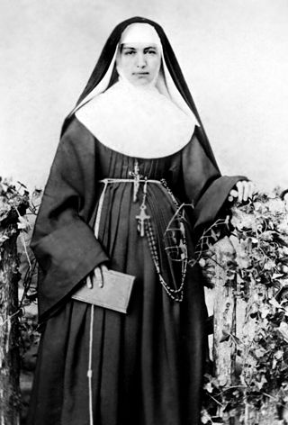
<span class="mw-page-title-main">Marianne Cope</span> German-born American religious sister (1838–1918)

Marianne Cope, OSF,, was a German-born American religious sister who was a member of the Sisters of St. Francis of Syracuse, New York, and founding leader of its St. Joseph's Hospital in the city, among the first of 50 general hospitals in the country. Known also for her charitable works, in 1883 she relocated with six other sisters to Hawaiʻi to care for persons suffering leprosy on the island of Molokaʻi and aid in developing the medical infrastructure in Hawaiʻi. Despite direct contact with the patients over many years, Cope did not contract the disease.

<span class="mw-page-title-main">Kalihi</span> Neighborhood in Honolulu, Hawaii, US

Kalihi is a neighborhood of Honolulu on the island of Oʻahu in Hawaiʻi, United States. Split by Likelike Highway, it is flanked by Liliha, Chinatown, and Downtown Honolulu to the east and Mapunapuna, Moanalua, and Salt Lake to the west.

<span class="mw-page-title-main">Kalaupapa, Hawaii</span> Unincorporated community in the state of Hawaii, United States

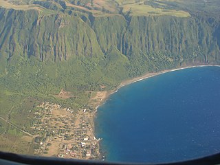
Kalaupapa is a small unincorporated community and Hawaiian home land on the island of Molokaʻi, within Kalawao County in the U.S. state of Hawaii. In 1866, during the reign of Kamehameha V, the Hawaii legislature passed a law that resulted in the designation of Molokaʻi as the site for a leper colony, where patients who were seriously affected by leprosy could be quarantined, to prevent them from infecting others. At the time, the disease was little understood: it was believed to be highly contagious and was incurable until the advent of antibiotics. The communities where people with leprosy lived were under the administration of the Board of Health, which appointed superintendents on the island.

<span class="mw-page-title-main">Kalaupapa National Historical Park</span> National Historical Park of the United States

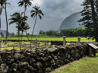
Kalaupapa National Historical Park is a United States National Historical Park located in Kalaupapa, Hawaiʻi, on the island of Molokaʻi. Coterminous with the boundaries of Kalawao County and primarily on Kalaupapa peninsula, it was established by Congress in 1980 to expand upon the earlier National Historic Landmark site of the Kalaupapa Leper Settlement. It is administered by the National Park Service. Its goal is to preserve the cultural and physical settings of the two leper colonies on the island of Molokaʻi, which operated from 1866 to 1969 and had a total of 8500 residents over the decades.

<span class="mw-page-title-main">Kalawao, Hawaii</span> Unincorporated community in the state of Hawaii, United States

Kalawao is a location on the eastern side of the Kalaupapa Peninsula of the island of Molokai, in Hawaii, which was the site of Hawaii's leper colony between 1866 and the early 20th century. Thousands of people in total came to the island to live in quarantine. It was one of two such settlements on Molokai, the other being Kalaupapa. Administratively Kalawao is part of Kalawao County. The placename means "mountain-side wild woods" in Hawaiian.

<span class="mw-page-title-main">Molokaʻi Light</span> United States historic place

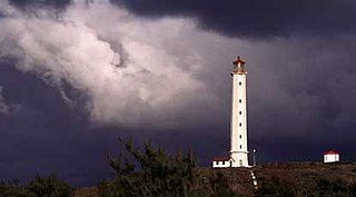
Molokai Light, also known as U.S. Coast Guard Molokai Light, is a lighthouse in Kalawao County, Hawaii, on the island of Molokai. It was built in 1909 and was listed on the National Register of Historic Places in 1982.

Leprosy stigma is a type of social stigma, a strong negative feeling towards a person with leprosy relating to their moral status in society. It is also referred to as leprosy-related stigma, leprostigma, and stigma of leprosy. Since ancient times, leprosy instilled the practice of fear and avoidance in many societies because of the associated physical disfigurement and lack of understanding behind its cause. Because of the historical trauma the word "leprosy" invokes, the disease is now referred to as Hansen's disease, named after Gerhard Armauer Hansen who discovered Mycobacterium leprae, the bacterial agent that causes Hansen's disease. Those who have suffered from Hansen's disease describe the impact of social stigma as far worse than the physical manifestations despite it being only mildly contagious and pharmacologically curable. This sentiment is echoed by Weis and Ramakrishna, who noted that "the impact of the meaning of the disease may be a greater source of suffering than symptoms of the disease".

The Hawaii State Department of Health (DOH) is a state agency of Hawaiʻi, with its headquarters in Honolulu CDP, Honolulu County, on the island of Oʻahu.

<span class="mw-page-title-main">William Keolaloa Sumner</span>

William Keolaloa Kahānui Sumner, Jr. was a high chief of the Kingdom of Hawaii through his mother's family; his father was an English captain from Northampton. Sumner married a Tahitian princess. Aided by royal family connections, he became a major landowner and politician in Hawaii.

<span class="mw-page-title-main">Loretta Fuddy</span> American social worker and politician

Loretta Jean Fuddy was an American health official and social worker from the U.S. state of Hawaii. Fuddy served simultaneously as the Director of the Hawaii Department of Health and the Mayor of Kalawao County from 2011 until her death. Under Hawaii state law, the Hawaii Department of Health administers Kalawao County, and the Director of the Hawaii Department of Health, who is appointed by the governor, simultaneously serves as the Mayor of Kalawao County while in office.

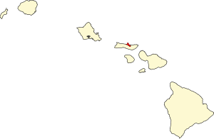
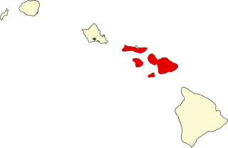
The Mayor of Kalawao County is the chief executive officer of Kalawao County in the U.S. state of Hawaii. Kalawao County, which lacks a local government, is administered by the Hawaii Department of Health. Under Hawaii state law, the Director of the Hawaii Department of Health, who is appointed by the Governor of Hawaii, simultaneously serves as the Mayor of Kalawao County while in office. The Mayor of Kalawao County holds executive powers similar to other elected Hawaiian mayors, including the responsibilities of health, public safety, and law and order. The Mayor appoints a county sheriff selected from Kalawao County residents. The Mayor visits Kalawao several times a year to meet with local residents. Kalawao County, which is located on the Kalaupapa Peninsula on the north coast of Moloka'i, consists of three villages - Kalaupapa, Kalawao, and Waikolu.
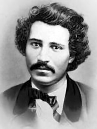
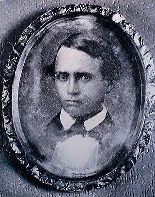
<span class="mw-page-title-main">Ambrose K. Hutchison</span> Hawaiian resident leader of the leper settlement of Kalaupapa

Ambrose Kanoealiʻi or Ambrose Kanewaliʻi Hutchison was a long-time Native Hawaiian resident of the Kalaupapa Leprosy Settlement on the island of Molokaʻi who resided there for fifty-three years from 1879 to his death in 1932. During his residence, he assumed a prominent leadership role in the patient community and served as luna or resident superintendent of Kalaupapa from 1884 to 1897.

<span class="mw-page-title-main">Leopoldina Burns</span> American Third Order Franciscan and missionary

Mary Leopoldina Burns, was an American religious sister who was a member of the Sisters of St Francis of Syracuse, New York, and a close companion and biographer of Marianne Cope during the 1883 Hansen's Disease epidemic on the island of Molokaʻi, Hawaii.

References

  1. Voss, Oscar (2012). "Is Kalawao County, on the north shore of Molokai, really a separate county?" . Retrieved January 25, 2015.
  2. "2020 Population and Housing State Data". United States Census Bureau. Retrieved August 12, 2021.
  3. "Kalaupapa National Historical Park". National Park Service. Retrieved August 11, 2022.
  4. "Tableau".
  5. "Kalawao County | Office of Hawaiian Affairs" (PDF). Office of Hawaiian Affairs. Archived (PDF) from the original on August 11, 2022. Retrieved August 11, 2022. Kalawao County has no county government; a sheriff is appointed by the Hawai'i Department of Health (DOH). The HRS Chapter 326, Sections 326-1-326-40 Hansen's Disease detail topics including patient treatment, care, services, expenses, and privacy; general excise, income, and real property tax exemptions; employment, compensation, and pensions; Kalaupapa store; fishing laws exemption; and Damien Memorial Chapel.
  6. "When the Last Patient Dies". The Atlantic . May 27, 2015. Archived from the original on August 11, 2022. Retrieved August 11, 2022.
  7. "Kalawao County | Office of Hawaiian Affairs" (PDF). Office of Hawaiian Affairs. p. 7. Retrieved August 11, 2022.
  8. Dingeman, Robbie (October 31, 2002). "Smallest county to ban smoking". Honolulu Advertiser . Retrieved January 2, 2014.
  9. Rawlings, Nate (December 12, 2013). "Hawaii Official Killed in Plane Crash". Time Magazine . Retrieved January 2, 2014.
  10. Uyeno, Kristine (December 12, 2013). "Hawaii Official Killed in Plane Crash". KHON . Archived from the original on January 4, 2014. Retrieved January 2, 2014.
  11. Kakesako, Gregg K. (December 12, 2013). "Pilot described 'catastrophic engine failure' in Molokai crash". Honolulu Star Advertiser . Archived from the original on December 21, 2013. Retrieved January 2, 2014.
  12. "Department of Health Administrative Offices". State of Hawaiʻi. Retrieved September 28, 2010.
  13. "Hawaii's 4 (or 5) Counties". Archived from the original on August 5, 2007. Retrieved January 22, 2014.
  14. "The Judiciary – State of Hawaii – Annual Report – July 1, 1986 to June 30, 1987". pp. 16, 26.
  15. "US Gazetteer files: 2010, 2000, and 1990". United States Census Bureau. February 12, 2011. Retrieved April 23, 2011.
  16. "Kalaupapa Ahupua'a neighborhood in Kalaupapa, Hawaii (HI), 96742 subdivision profile – real estate, apartments, condos, homes, community, population, jobs, income, streets". www.city-data.com.
  17. "Waikolu Ahupua'a neighborhood in Kaunakakai, Hawaii (HI), 96742 subdivision profile – real estate, apartments, condos, homes, community, population, jobs, income, streets". www.city-data.com.
  18. Mark D. McCoy: The Lands of the Hina: An Archeological Overview and Assessment of Kalaupapa National Historical Park, Molokaʻi, Chapter 8: Assessment Archived 2011-09-01 at the Wayback Machine , Seite 33
  19. "Annual Estimates of the Resident Population for Counties: April 1, 2020 to July 1, 2023". United States Census Bureau. Retrieved March 31, 2024.
  20. "U.S. Decennial Census". United States Census Bureau. Retrieved June 28, 2014.
  21. "Historical Census Browser". University of Virginia Library. Retrieved June 28, 2014.
  22. "Population of Counties by Decennial Census: 1900 to 1990". United States Census Bureau. Retrieved June 28, 2014.
  23. "Census 2000 PHC-T-4. Ranking Tables for Counties: 1990 and 2000" (PDF). United States Census Bureau. Retrieved June 28, 2014.
  24. "State & County QuickFacts". United States Census Bureau. Archived from the original on June 6, 2011. Retrieved June 28, 2014.
  25. "U.S. Census website". United States Census Bureau . Retrieved January 31, 2008.
  26. "Bureau of the Census: HAWAII. Population of Counties by Decennial Census: 1900 to 1990".
  27. "Planning for Kalaupapa's future means remembering its past". May 8, 2015.
  28. Wong, Alia (May 27, 2015). "People With Leprosy Were Exiled There—Should It Be a Tourist Destination?". The Atlantic.
  29. "Life Today in Kalaupapa". National Park Service . Retrieved January 22, 2014.
  30. Leip, David. "Dave Leip's Atlas of U.S. Presidential Elections". uselectionatlas.org. Retrieved May 26, 2017.
  31. "Statewide Precinct Detail" (PDF). State of Hawaii Office of Elections. Retrieved March 13, 2020.
  32. "2020 CENSUS - SCHOOL DISTRICT REFERENCE MAP: Kalawao County, HI" (PDF). U.S. Census Bureau . Retrieved July 22, 2022. - Text list

21°11′49″N156°58′02″W / 21.19694°N 156.96722°W / 21.19694; -156.96722