
Boundary Peak is a mountain in Esmeralda County, Nevada, United States. With a peak elevation of 13,147 feet (4,007 m), it is the highest natural point in the state of Nevada.

Mount Ritter is the highest mountain in Madera County, California, in the Western United States, at an elevation of 13,149 feet (4,008 m). It is also the highest and most prominent peak of its namesake, the Ritter Range, a subrange of the Sierra Nevada in the Ansel Adams Wilderness of the Inyo and Sierra National Forests. Mount Ritter is the 15th highest mountain peak in California with at least 500 meters of topographic prominence.
Red Slate Mountain is a summit in the Sierra Nevada. It lies along the Sierra Crest that divides Fresno County from Mono County, California.
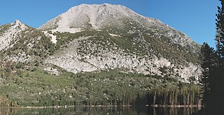
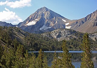
Mount Morgan is the highest point on Nevahbe Ridge in the Sherwin Range of the Sierra Nevada. It lies in Mono County, California, between McGee Canyon and Hilton Lakes. The mountain is in the John Muir Wilderness Area in the Inyo National Forest.
Mount Isolation is a mountain located in Coos County, New Hampshire. The mountain is part of the Presidential Range of the White Mountains. Mount Isolation is the highest peak on the Montalban Ridge which extends south from Boott Spur.

Mount Eddy is the highest peak of the Trinity Mountains, a mountain range of the Klamath Mountains System, located in Siskiyou County, and Trinity County in northern California.

Freel Peak is a mountain located in the Carson Range, a spur of the Sierra Nevada, near Lake Tahoe in California.

Sonora Peak is a mountain in the Central Sierra Nevada of California north of Sonora Pass. Located on the boundary between Alpine and Mono counties, it is the highest point in Alpine County. Due to the high elevation, most of the precipitation this mountain receives consists of snow.

Clark Peak is the highest summit of the Medicine Bow Mountains range of the Rocky Mountains of North America. The prominent 12,960-foot (3,950 m) peak is located in the Rawah Wilderness of Routt National Forest, 6.3 miles (10.1 km) north-northwest of Cameron Pass, Colorado, United States, on the drainage divide between Jackson and Larimer counties. Clark Peak is the highest point of Jackson County and the entire drainage basin of the North Platte River.
Escudilla Mountain is located in Apache County, Arizona, United States, and is part of the White Mountains. The peak is approximately 3.5 miles from the Arizona-New Mexico border. The summit is the highest point in the Escudilla Wilderness which is administered as part of the Apache-Sitgreaves National Forest. It is also the third-highest mountain peak in Arizona.

Mount Morgan is a mountain located in northwestern Inyo County, California, in the John Muir Wilderness of the Inyo National Forest.
Flat Top Mountain is the highest summit of the Flat Tops in the Rocky Mountains of North America. The prominent 12,361-foot (3,768 m) peak is located in the Flat Tops Wilderness, 19.1 miles (30.7 km) south-southwest of the Town of Oak Creek, Colorado, United States, on the drainage divide between Routt National Forest and White River National Forest. The summit of Flat Top Mountain is the highest point in Garfield County, Colorado.
Crater Peak is the highest summit of Grand Mesa in the Rocky Mountains of North America. The prominent 11,333-foot (3,454 m) peak is located on the drainage divide separating Grand Mesa National Forest and Gunnison National Forest, 12.3 miles (19.8 km) north-northwest of the Town of Paonia in Delta County, Colorado, United States.
Big Creek Peak, at 11,350 feet (3,460 m) above sea level is a peak in the Lemhi Range of Idaho. The peak is located in Lemhi County on the border of Caribou-Targhee National Forest and Salmon-Challis National Forest. It is about 1.1 mi (1.8 km) northwest of Flatiron Mountain and 23.7 mi (38.1 km) northwest of Bell Mountain, its line parent. It is the 55th highest peak in Idaho.
South River Peak, elevation 13,154 ft (4,009 m), is a summit in the San Juan Mountains of southwestern Colorado, United States. The mountain is in the Weminuche Wilderness of Rio Grande National Forest.

Mount Powell is the highest summit of the Gore Range in the Rocky Mountains of North America. The prominent 13,586-foot (4,141 m) thirteener is located in the Eagles Nest Wilderness, 8.5 miles (13.7 km) north by east of the Town of Vail, Colorado, United States, along the drainage divide separating White River National Forest and Eagle County from Arapaho National Forest and Summit County. Mount Powell was named in honor of John Wesley Powell who climbed to the summit in 1868.
California Peak is a high mountain summit in the Sangre de Cristo Range of the Rocky Mountains of North America. The 13,855-foot (4,223 m) thirteener is located on the Sierra Blanca Massif, 12.1 miles (19.5 km) north of the Town of Blanca, Colorado, United States, on the drainage divide separating in Rio Grande National Forest and Alamosa County from San Isabel National Forest and Huerfano County.

Mount Dubois is in the White Mountains in the U.S. state of California. Mount Dubois is in the White Mountains Wilderness of Inyo National Forest.
Waucoba Mountain with an elevation of 11,128 feet (3,392 m) is the highest peak in the Inyo Mountains of eastern California. It is in the Inyo Mountains Wilderness and the Inyo National Forest. It has a clean prominence of 3,923 feet (1,196 m).

Eagle Peak is a mountain in the Sierra Nevada of Mono County, California. The summit is set in Hoover Wilderness on land managed by Humboldt–Toiyabe National Forest. Eagle Peak is the highest peak on Buckeye Ridge. Other peaks on this ridge include Hunewill Peak and Victoria Peak. The first ascent of Eagle Peak was made September 1905 by George Davis, A. H. Sylvester, and Pearson Chapman of the United States Geological Survey.

