
Cottonwood County is a county in the U.S. state of Minnesota. As of the 2010 United States Census, the population was 11,687. Its county seat is Windom.

Cottonwood Heights is a city located in Salt Lake County, Utah, United States, along the east bench of the Salt Lake Valley. It lies south of the cities of Holladay and Murray, east of Midvale, and north of Sandy within the Salt Lake City, Utah Metropolitan Statistical Area. Following a successful incorporation referendum in May 2004, the city was incorporated on January 14, 2005. Cottonwood Heights had been a Census-designated place (CDP) before incorporation. The population as of the 2010 census was 33,433. This is a significant increase over the CDP's 2000 census count of 27,569.

Mingus Mountain is a mountain located in the U.S. state of Arizona in the Black Hills mountain range. It is located within the Prescott National Forest traversed by State Route 89A approximately midway between Cottonwood and Prescott. The summit can be reached via Forest Service roads that branch off from State Route 89A. From the mountain, there are views of the Verde Valley, Sycamore Canyon Wilderness and the towns of Cottonwood, Jerome, and Clarkdale. The Woodchute Wilderness, north of the summit of 89A, also offers views and hiking trails. There are several National Forest campgrounds in the area and it is the transmitter location for Prescott full-service television station KAZT-TV and several low-power television stations serving Cottonwood, Clarkdale, Camp Verde and Prescott Valley. Mingus Mountain is also the premier flying site of the Arizona Hang Gliding and Paragliding Association.

The Wasatch Range is a mountain range that stretches approximately 160 miles (260 km) from the Utah-Idaho border, south through central Utah in the western United States. It is the western edge of the greater Rocky Mountains, and the eastern edge of the Great Basin region. The northern extension of the Wasatch Range, the Bear River Mountains, extends just into Idaho, constituting all of the Wasatch Range in that state.

The Sawatch Range is a high and extensive mountain range in central Colorado which includes eight of the twenty highest peaks in the Rocky Mountains, including Mount Elbert, at 14,440 feet (4,401 m) elevation, the highest peak in the Rockies.

Snowbird is an unincorporated community in Little Cottonwood Canyon in the Wasatch Range of the Rocky Mountains near Salt Lake City, Utah, U.S. It is most famous for Snowbird Ski and Summer Resort, an alpine skiing and snowboarding area, which opened in December 1971.
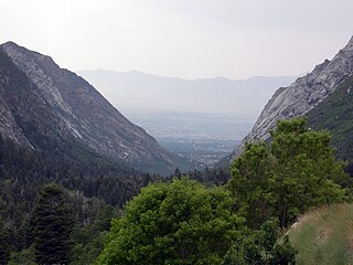
Little Cottonwood Canyon lies within the Wasatch-Cache National Forest along the eastern side of the Salt Lake Valley, roughly 15 miles from Salt Lake City, Utah. The canyon is part of Granite, a CDP and "Community Council" designated by Salt Lake County. The canyon is a glacial trough, carved by an alpine glacier during the last ice age, 15,000 to 25,000 years ago. A number of rare and endemic plant species are found in the canyon's Albion Basin. Mountain goats inhabit the surrounding mountains.

Crestone Peak is the seventh-highest summit of the Rocky Mountains of North America and the U.S. state of Colorado. The prominent 14,300-foot (4,359 m) fourteener is the highest summit of the Crestones and the second-highest summit in the Sangre de Cristo Range after Blanca Peak. The summit is located in the Sangre de Cristo Wilderness of Rio Grande National Forest, 5.0 miles (8.1 km) east by south of the Town of Crestone in Saguache County, Colorado, United States.

The Cottonwood Mountains range is found in Death Valley National Park in Inyo County, California, U.S.

Solitude Mountain Resort is a ski resort located in the Big Cottonwood Canyon of the Wasatch Mountains, thirty miles southeast of Salt Lake City, Utah. With 66 trails, 1,200 acres (4.9 km2) and 2,047 feet (624 m) vertical, Solitude is one of the smaller ski resorts near Salt Lake City, along with its neighbor Brighton. It is a family-oriented mountain, with a wider range of beginner and intermediate slopes than other nearby ski resorts; 50% of its slopes are graded "beginner" or "intermediate," the highest such ratio in the Salt Lake City area. Solitude was one of the first major US resorts to adopt an RFID lift ticket system, allowing lift lines to move more efficiently while reducing "lift poaching". It was followed by Alta Ski Area in 2007. Solitude is adjacent to Brighton Ski Resort near the top of Big Cottonwood Canyon. Solitude and Brighton offer a common "Solbright Pass" which provides access to both resorts for a nominal surcharge.

Big Cottonwood Canyon is a canyon in the Wasatch Range 12 miles (19 km) southeast of Salt Lake City in the U.S. state of Utah. The 15-mile (24 km)-long canyon provides hiking, biking, picnicking, rock-climbing, camping and fishing in the summer. Its two ski resorts, Brighton and Solitude, are popular among skiers and snowboarders. The canyon is accessed by The Big Cottonwood Canyon Scenic Byway (SR-190), which runs its length to Guardsman Pass at the top of the canyon, allowing travel to Park City in the summer months.

The Tuya Range is a rmountain range in the Stikine Ranges of the Cassiar Mountains in the far north of the Canadian province of British Columbia, near its border with the Yukon Territory and to the southwest of Watson Lake, Yukon, which is the nearest major settlement.
State Route 190 or the Big Cottonwood Canyon Scenic Byway is primarily an east and west scenic highway located in Salt Lake County, Utah that begins at I-215 and runs through Big Cottonwood Canyon including the Brighton Loop and ends at the Salt Lake and Wasatch County line.

Cottonwood Butte is a mountain and modest ski area in the western United States, located in north central Idaho, west of nearby Cottonwood. Its summit elevation is 5,730 feet (1,747 m) above sea level and is the highest point on the Camas Prairie, 2,100 feet (640 m) above Cottonwood.
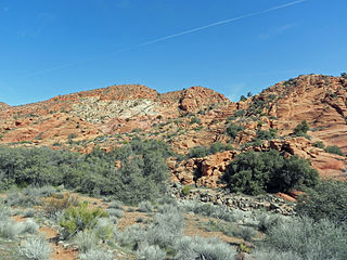
Cottonwood Canyon Wilderness is a 11,712-acre (47.4 km2) wilderness area in the US state of Utah. It was designated March 30, 2009, as part of the Omnibus Public Land Management Act of 2009. Located adjacent to the southern edge of the Dixie National Forest, it encompasses and protects a transition zone between the Colorado Plateau to the east and the Mojave Desert to the west. It is bordered by the Cottonwood Forest Wilderness to the northeast and is itself a part of the Red Cliffs National Conservation Area.

Cottonwood Forest Wilderness is a 2,643-acre (10.7 km2) wilderness area in the US state of Utah. It was designated March 30, 2009, as part of the Omnibus Public Land Management Act of 2009. Located within the Dixie National Forest near the base of the Pine Valley Mountains, it is adjacent to the Cottonwood Canyon Wilderness, which is part of the Red Cliffs National Conservation Area.
Cottonwood Air Force Station is a former United States Air Force General Surveillance Radar station. The radar site was located at the summit of Cottonwood Butte, 5.7 miles (9.2 km) west-northwest of Cottonwood in Idaho County, Idaho. It was closed in 1965 and transferred to the state of Idaho in 1974, when it was converted to its present use as a minimum-security correctional facility.
Roachville is a former small mining settlement, now in Inyo County, California. It was founded in 1861 on the east slope of the White Mountains, at the lower reaches of Cottonwood Creek northwest of White Mountain City.

The Peacock Mountains are a small, 26-mi (42 km) long mountain range in northwest Arizona, USA. The range is a narrow sub-range, and an extension north, at the northeast of the Hualapai Mountains massif, which lies to the southwest. The range is defined by the Hualapai Valley to the northwest, and north and south-flowing washes on its east border, associated with faults and cliffs; the Cottonwood Cliffs are due east, and are connected to the Aquarius Cliffs southward at the west perimeter of the Aquarius Mountains; the cliffs are a result of the Aquarius Fault, which is an extension southward from the Grand Wash Cliffs and Grand Wash Fault which crosses the Colorado River at Lake Mead, and the west perimeter of the Grand Canyon/Colorado Plateau.
Cottonwood Creek is a major stream and tributary of the Sacramento River in Northern California. About 68 miles (109 km) long measured to its uppermost tributaries, the creek drains a large rural area bounded by the crest of the Coast Ranges, traversing the northwestern Sacramento Valley before emptying into the Sacramento River near the town of Cottonwood. For its entire length, it defines the boundary of Shasta and Tehama counties. Because Cottonwood Creek is the largest undammed tributary of the Sacramento River, it is known for its Chinook salmon and steelhead runs.


