Southern California is a geographic and cultural region that generally comprises California's southernmost counties, and is the second most populous urban agglomeration in the United States. The region is traditionally described as eight counties, based on demographics and economic ties: Imperial, Los Angeles, Orange, Riverside, San Bernardino, San Diego, Santa Barbara, and Ventura. The more extensive 10-county definition, which includes Kern and San Luis Obispo counties, is also used and is based on historical political divisions.

Scouting in California has a long history, from the 1910s to the present day, serving thousands of youth in programs related to their environments.
The Santa Clara Valley runs south-southeast from the southern end of San Francisco Bay in Northern California in the United States. The northern, urbanized end of the valley is part of a region locally known as the "South Bay" and also part of the electronics, research, and technology area known as Silicon Valley. Santa Clara Valley consists of most of Santa Clara County, including its county seat, San Jose, as well as a small portion of San Benito County. The valley, named after the Spanish Mission Santa Clara, was for a time known as the Valley of Heart's Delight for its high concentration of orchards, flowering trees, and plants. Until the 1960s it was the largest fruit producing and packing region in the world with 39 canneries.

Pacheco Pass, elevation 1,368 ft (417 m), is a low mountain pass located in the Diablo Range in southeastern Santa Clara County, California. It is the main route through the hills separating the Santa Clara Valley and the Central Valley.

Monument Peak is a mountain peak located southeast of Fremont and northeast of Milpitas, in the East Bay region of the San Francisco Bay Area, in California.
Black Mountain, also known as Mount Day, is a mountain in the Diablo Range of eastern Santa Clara County, California, east of Poverty Ridge and Arroyo Hondo, and about 10 miles (16 km) from Milpitas.

Ed R. Levin County Park is the largest park in Milpitas, California. It is run by the Santa Clara County Parks and Recreation Department and is located in the chaparral foothills of Diablo Range east of the Santa Clara Valley. Monument Peak can be accessed through trails in the park. The park's recreational facilities include a hang gliding and paragliding area, a dog park, and horseback riding areas. Ed R. Levin County Park has two lakes, Sandy Wool Lake and Spring Valley Pond. Both of them are reservoirs which collect runoff water from the hills to the east. It is home to some of the East Bay Walls.

Coyote Creek is a river that flows through the Santa Clara Valley in California, United States.
The South Bay Aqueduct is an aqueduct located in the eastern part of the San Francisco Bay Area. It conveys water from the Sacramento-San Joaquin Delta through over forty miles of pipelines and canals. It begins in north-eastern Alameda County on the California Aqueduct's Bethany Reservoir serving as the forebay. The aqueduct flows along the eastern and southern edges of the Livermore Valley. Then it flows through a series of tunnels to an end in the foothills of eastern San Jose, 5 miles (8 km) from downtown San Jose, California.
The Northern California Rugby Football Union (NCRFU) is the Geographical Union (GU) for rugby union teams in Northern California, as well as northern Nevada. The NCRFU is part of USA Rugby.

The San Felipe Hills are a mountain range in Santa Clara County, California, located partly in the city of San Jose.
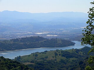
Anderson Lake, informally called Anderson Reservoir, is an artificial lake in Santa Clara County, California, United States, near Morgan Hill. A 4,275-acre (1,730 ha) county park surrounds the reservoir and provides limited fishing, picnicking, and hiking activities. Although swimming is prohibited, boating, water-skiing and jet-skiing are permitted in the reservoir.

Santa Clara County, officially the County of Santa Clara, is California's 6th most populous county, with a population of 1,781,642, as of the 2010 census. The county seat and largest city is San Jose, the 10th most populous city in the United States and California's 3rd most populous city.
El Camino Viejo a Los Ángeles, also known as El Camino Viejo and the Old Los Angeles Trail, was the oldest north-south trail in the interior of Spanish colonial Las Californias (1769–1822) and Mexican Alta California (1822–1848), present day California. It became a well established inland route, and an alternative to the coastal El Camino Real trail used since the 1770s in the period.

Diablo Range is an unincorporated, census county division (CCD) located in the Diablo Mountains Range, on the eastern side of Santa Clara County, California.

South Santa Clara Valley is a census county division (CCD) located in south Santa Clara County, California. The area covers approximately 118 square miles (310 km2), and includes the cities of Morgan Hill, San Martin, and Gilroy as well as their immediate outlying unincorporated areas. The area is bounded by Coyote to the north, Llagas-Uvas to the west, Diablo Range to the east, and San Benito County to the south.
