Barstow is a city in San Bernardino County, California, in the Mojave Desert of Southern California. Located in the Inland Empire region of California, the population was 25,415 at the 2020 census. Barstow is an important crossroads for the Inland Empire and home to Marine Corps Logistics Base Barstow.

The Mojave Desert is a desert in the rain shadow of the southern Sierra Nevada mountains and Transverse Ranges in the Southwestern United States. Named for the indigenous Mohave people, it is located primarily in southeastern California and southwestern Nevada, with small portions extending into Arizona and Utah.

The Mojave River is an intermittent river in the eastern San Bernardino Mountains and the Mojave Desert in San Bernardino County, California, United States. Most of its flow is underground, while its surface channels remain dry most of the time, except for the headwaters and several bedrock gorges in the lower reaches.

Calico is a ghost town and former mining town in San Bernardino County, California, United States. Located in the Calico Mountains of the Mojave Desert region of Southern California, it was founded in 1881 as a silver mining town, and was later converted into a county park named Calico Ghost Town. Located off Interstate 15, it lies 3 miles (4.8 km) equidistant from Barstow and Yermo. Giant letters spelling CALICO are visible, from the highway, on the Calico Peaks behind it. Walter Knott purchased Calico in the 1950s, and rebuilt all but the five remaining original buildings to look as they did in the 1880s. Calico received California Historical Landmark #782, and in 2005 was proclaimed by then-Governor Arnold Schwarzenegger to be California's Silver Rush Ghost Town.

Pisgah Crater, or Pisgah Volcano, is a young volcanic cinder cone rising above a lava plain in the Mojave Desert, between Barstow and Needles, California in San Bernardino County, California. The volcanic peak is around 2.5 miles (4.0 km) south of historic U.S. Route 66-National Old Trails Highway and of Interstate 40, and west of the town of Ludlow. The volcano had a historic elevation of 2,638 feet (804 m), but has been reduced to 2,545 feet (776 m) due to mining.

The Victor Valley is a valley in the Mojave Desert and subregion of the Inland Empire, in San Bernardino County in Southern California.
Bagdad is a ghost town in the Mojave Desert, in San Bernardino County, California.

Yermo is an unincorporated town and census-designated place (CDP) in the Mojave Desert in San Bernardino County, California. It is 13 miles (21 km) east of Barstow on Interstate 15, just south of the Calico Mountains. Its population was estimated at 1,750 in 2009.

Daggett is an unincorporated town located in San Bernardino County, California, in the United States. The town is located on Interstate 40, ten miles (16 km) east of Barstow, at an elevation of approximately 2,000 feet (610 m). The town has a population of about 200. The ZIP code is 92327 and the community is inside area code 760.
The Calico Early Man Site is an archaeological site in an ancient Pleistocene lake located near Barstow in San Bernardino County in the central Mojave Desert of Southern California. This site is on and in late middle-Pleistocene fanglomerates known variously as the Calico Hills, the Yermo Hills, or the Yermo formation. Holocene evidence includes petroglyphs and trail segments that are probably related to outcrops of local high-quality siliceous rock.
Oro Grande is an unincorporated community in the Mojave Desert of San Bernardino County, California, United States. It lies on the city boundary of Victorville and Adelanto. It is at 3,000 feet (910 m) elevation in Victor Valley north of the San Bernardino mountain range. It is located on old Route 66 near Interstate 15 between Victorville and Barstow. The ZIP code is 92368 and the community is inside area codes 442 and 760. Less than 1,000 residents live in the unincorporated area.

Newberry Springs is an unincorporated community in the western Mojave Desert of Southern California, located at the foot of the Newberry Mountains in San Bernardino County, California, United States. Newberry Spring is a spring that in the 19th century supplied water to the local Santa Fe Railway and originally was a camping place. The population at the 2000 census was 2,895.
The Tiefort Mountains are located in the Mojave Desert in San Bernardino County, southeastern California in the United States.

Silver Valley Unified School District is located in the High Desert of Southern California, between Los Angeles and Las Vegas. The district covers an area of approximately 3,345 square miles (8,660 km2), equivalent in size to the combined states of Rhode Island and Delaware.

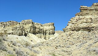
Rainbow Basin is a geological formation in the Calico Peaks range, located approximately 8 miles (13 km) north of Barstow in the Mojave Desert in San Bernardino County, California.
Ludlow is an unincorporated community in the Mojave Desert on Interstate 40, located in San Bernardino County, California, United States. The older remains of the ghost town are along historic Route 66.
The Calico Peaks are geologically and historically colorful mountains in the Calico Mountains Range in the Mojave Desert of San Bernardino County and Inyo County, California. They are located just north of Barstow, Yermo, and Interstate 15.

The Salt Spring Hills are a low mountain range in the Mojave Desert, in northern San Bernardino County, California. They are just outside the southeastern corner of Death Valley National Park, southeast of the Saddle Peak Hills. The road between Shoshone and Baker passes through the hills.
The Barstow Formation is a series of limestones, conglomerates, sandstones, siltstones and shales exposed in the Mojave Desert near Barstow in San Bernardino County, California.