
Inyo County is a county in the eastern central part of California, located between the Sierra Nevada mountains and the state of Nevada. As of the 2010 census, the population was 18,546. The county seat is Independence.

Shoshone is a census designated place (CDP) in Inyo County, California, United States. The population was 31 at the 2010 census, down from 52 at the 2000 census.

Tecopa is a census-designated place in the Mojave Desert, in Inyo County, California, United States. Tecopa is located 9 miles (14 km) south-southeast of Shoshone, at an elevation of 1,339 feet (408 m). The population was 150 at the 2010 census, up from 99 at the 2000 census.

The Amargosa River is an intermittent waterway, 185 miles (298 km) long, in southern Nevada and eastern California in the United States. It drains a high desert region, the Amargosa Valley in the Amargosa Desert northwest of Las Vegas, into the Mojave Desert, and finally into Death Valley where it disappears into the ground aquifer. Except for a small portion of its route in the Amargosa Canyon in California and a small portion at Beatty, Nevada, the river flows above ground only after a rare rainstorm washes the region. A 26-mile (42 km) stretch of the river between Shoshone and Dumont Dunes is protected as a National Wild and Scenic River. At the south end of Tecopa Valley the Amargosa River Natural Area protects the habitat.
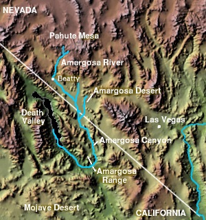
The Amargosa Valley is the valley through which the Amargosa River flows south, in Nye County, southwestern Nevada and Inyo County in the state of California. The south end is alternately called the "Amargosa River Valley'" or the "Tecopa Valley." Its northernmost point is around Beatty, Nevada and southernmost is Tecopa, California, where the Amargosa River enters into the Amargosa Canyon.
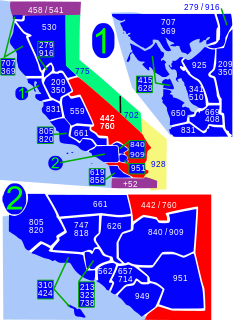
Area code 760 is a California telephone area code that was split from area code 619 on March 22, 1997. Area code 442 is an overlay of 760 that became effective on November 21, 2009. It encompasses much of the southeastern and southernmost portions of California. The area includes Imperial, Inyo, and Mono counties, as well as portions of San Diego, Riverside, San Bernardino, Los Angeles and Kern counties.

The Tecopa pupfish is an extinct subspecies of the Amargosa pupfish. The small, heat-tolerant pupfish was endemic to the outflows of a pair of hot springs in the Mojave Desert of California. Habitat modifications and the introduction of non-native species led to its extinction in about 1970.

Rhyolite is a ghost town in Nye County, in the U.S. state of Nevada. It is in the Bullfrog Hills, about 120 miles (190 km) northwest of Las Vegas, near the eastern boundary of Death Valley National Park. The town began in early 1905 as one of several mining camps that sprang up after a prospecting discovery in the surrounding hills. During an ensuing gold rush, thousands of gold-seekers, developers, miners and service providers flocked to the Bullfrog Mining District. Many settled in Rhyolite, which lay in a sheltered desert basin near the region's biggest producer, the Montgomery Shoshone Mine.

Death Valley Junction is a tiny Mojave Desert unincorporated community in Inyo County, California, at the intersection of SR 190 and SR 127, in the Amargosa Valley and just east of Death Valley National Park. The zip code is 92328, the elevation is 2,041 ft (622 m), and the population is fewer than 4.
The Shoshone pupfish is a subspecies of Cyprinodon nevadensis from California in the United States. It is characterized by large scales and a "slab-sided," narrow, slender body, with the arch of the ventral contour much less pronounced than the dorsal. It also has fewer pelvic fin rays and scales than the other subspecies of C. nevadensis.
The Nopah Range is located in Inyo County, California, United States, near the eastern border with Nevada.

State Route 127 is a state highway in the U.S. state of California that connects Interstate 15 in Baker to Nevada State Route 373 at the Nevada state line, passing near the eastern boundary of Death Valley National Park. The entire length of the highway closely follows the central portion of the former Tonopah and Tidewater Railroad and loosely follows the Amargosa River.

State Route 160 is a state highway in southern Nevada, United States. It connects the southern Las Vegas Valley to U.S. Route 95 northwest of the city via the Pahrump Valley. The southern part of the route sees heavy traffic, mostly due to Pahrump's continued growth as a Las Vegas bedroom community.
State Route 372 is a short state highway in Nye County, Nevada, United States. The route connects the town of Pahrump to the southeast side of Death Valley National Park via California State Route 178. The route was formerly a part of State Route 52 until being renumbered in 1976.

Yucca Mountain is a mountain in Nevada, near its border with California, approximately 100 miles (160 km) northwest of Las Vegas. Located in the Great Basin, Yucca Mountain is east of the Amargosa Desert, south of the Nevada Test and Training Range and in the Nevada National Security Site. It is the site of the Yucca Mountain nuclear waste repository, which is currently identified by Congressional law as the nation's spent nuclear waste storage facility. However, while licensure of the site through the Nuclear Regulatory Commission is ongoing, political maneuvering led to the site being de-funded in 2010.
Noonday Camp, also known as Mill City, Noonday City, and Tecopa, is a ghost town located in the Mojave Desert east of Tecopa in Inyo County, California.
Death Valley Unified School District (DVUSD) is a public school district in Inyo County, California.

Amargosa Opera House and Hotel is a historic building and cultural center located in Death Valley Junction, in eastern Inyo County, California near Death Valley National Park. Resident artist Marta Becket staged dance and mime shows there from the late 1960s until her final show in February 2012. The Death Valley Junction Historic District is on the National Register of Historic Places and is owned by the nonprofit established by Becket for the preservation of the property.
Pahrump Valley is a Mojave Desert valley west of Las Vegas and the Spring Mountains massif in southern Nye County, Nevada, and eastern San Bernardino County, California. Pahrump, Nevada, is in the valley's center and the Tecopa and Chicago Valleys are immediately to the west. The valley has routes to Death Valley and a route to Las Vegas. Pahrump Valley Days is the annual event in February each year, along with the sanctioned JRH-HS Rodeo.

Lake Tecopa is a former lake in Inyo County, southern California. It developed during the Miocene and the Pleistocene within a tectonic basin close to the border with Nevada. Fed by the Amargosa River and some neighbouring washes, it eventually culminated to a surface area of 235 square kilometres (91 sq mi) around 186,000 years ago and left sediments. Afterwards, the Amargosa River cut a gorge out of the lake and into Death Valley with its Lake Manly, draining the lake. The present-day towns of Shoshone, California and Tecopa, California lie within the basin of the former lake.
