
The Sawtooth Range is a mountain range of the Rocky Mountains in central Idaho, United States, reaching a maximum elevation of 10,751 feet (3,277 m) at the summit of Thompson Peak. It encompass an area of 678 square miles (1,756 km2) spanning parts of Custer, Boise, Blaine, and Elmore counties, and is bordered to the east by the Sawtooth Valley. Much of the mountain range is within the Sawtooth Wilderness, part of the Sawtooth National Recreation Area and Sawtooth National Forest.
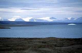
The Sawtooth Range is a jagged snow-capped mountain range on central Ellesmere Island, Nunavut, Canada. It lies between the Fosheim Peninsula and the Wolf Valley. The Sawtooth Range is a subrange of the Arctic Cordillera. It also runs through a Canadian Forces Station, called Eureka, a base used to study atmospheric changes.

The Boulder Mountains are part of the Rocky Mountains in the western United States. Located in central Idaho, they stretch from a few miles north of Ketchum to north to near Challis, and part of the range is within the Sawtooth National Recreation Area and partially within the Hemingway–Boulders Wilderness. The highest point in the range is Ryan Peak.

The Soldier Mountains are a mountain range in the U.S. state of Idaho, spanning northern Camas and eastern Elmore counties. The highest point in the range is Smoky Dome at 10,095 feet (3,077 m), and the range is bounded on the west and north by the South Fork Boise River. The mountains are located within Sawtooth National Forest north of Fairfield, Idaho. The Soldier Mountain Ski Area is located within the range to the east of Smoky Dome.

The Smoky Mountains are part of the Rocky Mountains and located on the west side of the Wood River Valley near Sun Valley, Idaho, in the Western United States. The range is within Sawtooth National Forest, while part of it is within the Sawtooth National Recreation Area. The highest point in the range is Saviers Peak at 10,441 ft (3,182 m).

Sublett Range High Point, at 7,492 feet (2,284 m) above sea level is the highest peak in the Sublett Range of Power County in southern Idaho. Sublett Range High Point is located in the east-central part of the range north of Snowville, Utah, and east of Malta, Idaho, and south of American Falls, Idaho in the Sublett Division of the Minidoka Ranger District of Sawtooth National Forest.

Merriam Peak, at 10,920 feet (3,330 m) is one of the peaks of the White Cloud Mountains of Custer County, Idaho. Merriam Peak is located in the middle of the range just north of Castle Peak, the highest point in the range. The peak is located in the White Clouds roadless area of Sawtooth National Recreation Area.

Mount Carter, at 10,590 feet (3,230 m) above sea level is the seventh highest peak in the Sawtooth Range of Idaho. The peak is located in the Sawtooth Wilderness of Sawtooth National Recreation Area on the border of Boise and Custer counties. The peak is located 0.32 mi (0.51 km) northwest of Mickey's Spire, its line parent, and 0.43 mi (0.69 km) west of Thompson Peak, the highest point in the range.

Mount Limbert, at 10,385 feet (3,165 m) above sea level is the 12th highest peak in the Sawtooth Range of Idaho. The peak is located in the Sawtooth Wilderness of Sawtooth National Recreation Area on the border of Boise and Custer counties. The peak is located 0.54 mi (0.87 km) southwest of Mount Carter, its line parent.
Moolack Mountain, also sometimes referred to as Baron Peak North, at 10,330 feet (3,150 m) above sea level is a peak in the Sawtooth Range of Idaho. The peak is located in the Sawtooth Wilderness of Sawtooth National Recreation Area in Boise County. The peak is located 1.3 mi (2.1 km) west of Mount Limbert, its line parent, and 0.5 mi (0.80 km) northwest of Baron Peak.
Baron Peak, at 10,297 feet (3,139 m) above sea level is a peak in the Sawtooth Range of Idaho. The peak is located in the Sawtooth Wilderness of Sawtooth National Recreation Area on the border of Boise and Custer counties. The peak is located 0.5 mi (0.80 km) southeast of Moolack Mountain, its line parent.

Payette Peak, at 10,221 feet (3,115 m) above sea level is a peak in the Sawtooth Range of Idaho. The peak is located in the Sawtooth Wilderness of Sawtooth National Recreation Area on the border of Boise and Custer counties. The peak is located 1.33 mi (2.14 km) south of Mount Cramer, its line parent. Payette Peak rises above the southwest end of Hidden Lake.
Cirque Lake Peak, at 10,210 feet (3,110 m) above sea level is a peak in the Sawtooth Range of Idaho. The peak is located in the Sawtooth Wilderness of Sawtooth National Recreation Area in Boise County. The peak is located 1.39 mi (2.24 km) north-northwest of Packrat Peak, its line parent.
Mount Iowa, at 10,327 feet (3,148 m) above sea level is a peak in the Sawtooth Range of Idaho. The peak is located in the Sawtooth Wilderness of Sawtooth National Recreation Area in Custer County. The peak is located 0.65 mi (1.05 km) south-southeast of Horstmann Peak, its line parent. It is about 0.7 mi (1.1 km) north of Braxon Peak and 1.1 mi (1.8 km) west of Mount Heyburn.
Dave's Peak, at 10,579 feet (3,224 m) above sea level is an unofficially named peak that is the ninth highest peak in the Sawtooth Range of Idaho. The peak is located in the Sawtooth Wilderness of Sawtooth National Recreation Area in Custer County. The peak is located 0.65 mi (1.05 km) northeast of Mount Cramer, its line parent. Profile and Lucille lakes are southeast of the peak, while Upper, Middle, and Lower Cramer lakes are northwest of the peak. Dave's Peak is south-southwest of Sevy Peak.
Merritt Peak, at 10,312 feet (3,143 m) above sea level is a peak in the Sawtooth Range of Idaho. The peak is located in the Sawtooth Wilderness of Sawtooth National Recreation Area in Custer County. The peak is located 1.08 mi (1.74 km) northwest of Williams Peak, its line parent. It is south-southwest of Goat Lake
McDonald Peak, at 10,068 feet (3,069 m) above sea level is a peak in the Sawtooth Range of Idaho. The peak is located in the Sawtooth Wilderness of Sawtooth National Recreation Area in Blaine County. The peak is located 1.93 mi (3.11 km) southeast of Parks Peak, its line parent. It is southwest of Pettit Lake.
Imogene Peak, at 10,125 feet (3,086 m) above sea level is a peak in the Sawtooth Range of Idaho. The peak is located in the Sawtooth Wilderness of Sawtooth National Recreation Area in Custer County. The peak is located 1.83 mi (2.95 km) north of Parks Peak, its line parent. Farley Lake is located south of the peak, and Imogene Lake is west of the peak.

McGown Peak, at 9,860 feet (3,010 m) above sea level is a peak in the Sawtooth Range of Idaho. The peak is located in the Sawtooth Wilderness of Sawtooth National Recreation Area in Custer County. The peak is located 3.25 mi (5.23 km) north-northwest of Alpine Peak, its line parent. McGown Peak rises above the southwest end of Stanley Lake.

Alpine Peak, at 9,861 feet (3,006 m) above sea level is a peak in the Sawtooth Range of Idaho. The peak is located in the Sawtooth Wilderness of Sawtooth National Recreation Area in Custer County. The peak is located 1 mi (1.6 km) northeast of Mount Regan, its line parent. Alpine Peak is south of Alpine Lake and east of Sawtooth Lake.


