
Whitehorse is the capital of the Yukon, and the largest city in Northern Canada. It was incorporated in 1950 and is located at kilometre 1426 on the Alaska Highway in southern Yukon. Whitehorse's downtown and Riverdale areas occupy both shores of the Yukon River, which rises in British Columbia and meets the Bering Sea in Alaska. The city was named after the White Horse Rapids for their resemblance to the mane of a white horse, near Miles Canyon, before the river was dammed.

The Municipality and Borough of Skagway is a first-class borough in Alaska on the Alaska Panhandle. As of the 2020 census, the population was 1,240, up from 968 in 2010. The population doubles in the summer tourist season in order to deal with the large number of summer tourists each year. Incorporated as a borough on June 25, 2007, it was previously a city in the Skagway-Yakutat-Angoon Census Area. The most populated community is the census-designated place of Skagway.
The Alaska Highway was constructed during World War II to connect the contiguous United States to Alaska across Canada. It begins at the junction with several Canadian highways in Dawson Creek, British Columbia, and runs to Delta Junction, Alaska, via Whitehorse, Yukon. When it was completed in 1942, it was about 2,700 kilometres (1,700 mi) long, but in 2012, it was only 2,232 km (1,387 mi). This is due to the realignments of the highway over the years, which has rerouted and straightened many sections. The highway opened to the public in 1948. Once legendary for being a rough, challenging drive, the highway is now paved over its entire length. Its component highways are British Columbia Highway 97, Yukon Highway 1, and Alaska Route 2.

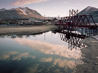
The White Pass and Yukon Route is a Canadian and U.S. Class III 3 ft narrow-gauge railroad linking the port of Skagway, Alaska, with Whitehorse, the capital of Yukon. An isolated system, it has no direct connection to any other railroad. Equipment, freight and passengers are ferried by ship through the Port of Skagway, and via road through a few of the stops along its route.
Carcross, originally known as Caribou Crossing, is an unincorporated community in Yukon, Canada, on Bennett Lake and Nares Lake. It is home to the Carcross/Tagish First Nation.

Erik Nielsen Whitehorse International Airport is an airport of entry located in Whitehorse, Yukon, Canada. It is part of the National Airports System, and is owned and operated by the Government of Yukon. The airport was renamed in honour of longtime Yukon Member of Parliament Erik Nielsen on December 15, 2008. The terminal handled 294,000 passengers in 2012, representing a 94% increase in passenger traffic since 2002. By 2017, this number had risen to 366,000. Air North is based in Whitehorse.

The Canol Road was part of the Canol Project and was built to construct a pipeline from Norman Wells, Northwest Territories, to Whitehorse, Yukon, during World War II. The pipeline no longer exists, but the 449 kilometres (279 mi) long Yukon portion of the road is maintained by the Yukon Government during summer months. The portion of the road that still exists in the NWT is called the Canol Heritage Trail. Both road and trail are incorporated into the Trans-Canada Trail.
The Ta'an Kwach'an Council or Ta'an Kwäch’än Council is a self-governing Indigenous government whose traditional territory is located around the Whitehorse and Lake Laberge area in Canada's Yukon Territory. It split from the Kwanlin Dün First Nation to negotiate a separate land claim. The language originally spoken by the Ta’an Kwäch’än was Southern Tutchone. The Ta’an Kwäch’än comprise people of Southern Tutchone, Tagish and Tlingit descent. Approximately 50 per cent of the Ta’an Kwäch’än citizens now live in Whitehorse, Yukon Territory, with the balance disbursed throughout the rest of Canada, in the United States of America, and abroad. The Ta'an Kwäch’än take their name from Tàa'an Män in the heart of their traditional territory - so they called themselves ″People from Lake Laberge″.
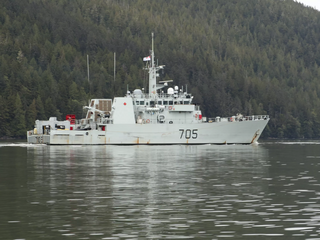
HMCS Whitehorse is a Kingston-class coastal defence vessel that has served in the Canadian Forces since 1998. Whitehorse is the sixth ship of her class. The first vessel named for the city in the Yukon, the ship is assigned to Maritime Forces Pacific (MARPAC) and is homeported at CFB Esquimalt.

Alkan Air Ltd. is an airline headquartered in Whitehorse, Yukon, Canada. The company operates seven-day-a-week charter and air ambulance (medevac) services. The Whitehorse and Mayo (seasonal) bases generally focus on wheel and floatplane charter and medevac services in northern and western Canada and Alaska. The Nanaimo, BC base provides charter and medevac services, focused primarily in western Canada, the western United States and Mexico. From 2016 to 2018, Alkan also operated scheduled flights between Erik Nielsen Whitehorse International Airport and Watson Lake Airport.
Randy Hahn is a Canadian-American play-by-play commentator for the San Jose Sharks on NBC Sports California, and has held that position for over 30 seasons. He has over 40 years of broadcast experience, mostly in hockey. Randy Hahn has worked the Stanley Cup Playoffs for TNT since 2022. He broadcast his 2,000th Sharks game on December 13, 2022, when the Sharks faced the Arizona Coyotes in San Jose. Along with analyst and ex-partner Drew Remenda, Hahn has won five Northern California Emmy Awards in the "On Camera Sports" section; one in 1999, and others in 2002, 2005, and 2008. Hahn was a PBP announcer in Konami's NHL Blades of Steel '99 and 2K Sports' NHL 2K9, NHL 2K10, and NHL 2K11.
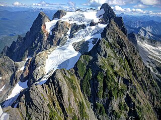
Whitehorse Mountain is a peak near the western edge of the North Cascades in Washington state. It is located just southwest of the Sauk River Valley town of Darrington, near the northern boundary of Boulder River Wilderness in Mount Baker-Snoqualmie National Forest. While not of particularly high absolute elevation, even for the North Cascades, it is notable for its large, steep local relief. For example, its north face rises 6,000 feet in only 1.8 mi (2.9 km).
Ibex Mountain is a young cinder cone in the Yukon Territory, Canada, located 33 km southwest of Whitehorse and 12 km southeast of Mount Arkell. It is in a group of basaltic cones and lava flows called Alligator Lake and is in the Northern Cordilleran Volcanic Province. It is believed Ibex Mountain last erupted during the Pleistocene. Ibex Mountain is at the head of the Ibex River, which is southeast of Whitehorse. There is a road that runs close to Ibex Lake on the southeast side of the summit. From there is the hike to the summit of the cone.
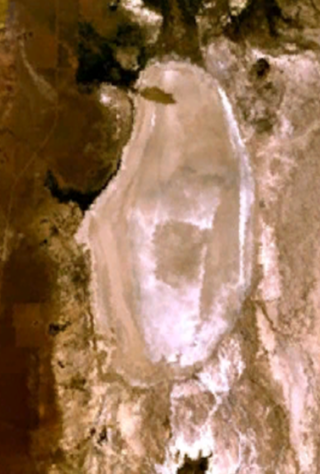
Alvord Lake is a seasonal shallow alkali lake in Harney County of the U.S. state of Oregon. Its elevation is 4,026 feet (1,227 m). It is located about 10 miles (16 km) southeast of Alvord Desert in the Alvord Basin and serves as terminus for all its streams. Its water level varies from dry to several feet deep. The nearest habitation is tiny Fields, 14.1 kilometres (8.8 mi) SSW.

The Trout Creek Mountains are a remote, semi-arid Great Basin mountain range mostly in southeastern Oregon and partially in northern Nevada in the United States. The range's highest point is Orevada View Benchmark, 8,506 feet (2,593 m) above sea level, in Nevada. Disaster Peak, elevation 7,781 feet (2,372 m), is another prominent summit in the Nevada portion of the mountains.

The Whitehorse Ranch is a historic cattle ranch in Harney and Malheur counties in the southeastern corner of Oregon, United States. The ranch was started in 1869 by John S. Devine, a well-known 19th-century cattle baron. It was originally the headquarters for the Todhunter and Devine Cattle Company. The ranch has been in the cattle business continuously since it was founded. Today, the Whitehorse Ranch includes 63,222 acres (255.85 km2) of deeded property and grazing rights on an additional 287,205 acres (1,162.28 km2) of public range land administered by the Bureau of Land Management.

So-Bahli-Alhi Glacier is in Snoqualmie National Forest in the U.S. state of Washington, on the north slopes of Whitehorse Mountain. Meaning lofty lady from the east in Native American language, So-Bahli-Alhi Glacier is along a climbing route to the summit of Whitehorse Mountain.
The 2017 ISF Men's World Championship is an international softball tournament that took place in Whitehorse, Canada from 7–16 July 2017. It was the 15th time the World Championship took place and the first time Whitehorse hosted the tournament.
The Whitehorse Formation is a geologic formation of Late Triassic age. It is present on the western edge of the Western Canada Sedimentary Basin in western Alberta and northeastern British Columbia. It was first described as a member of the Spray River Formation by P.S. Warren in 1945, who named it for Whitehorse Creek, a tributary of the McLeod River south of Cadomin, Alberta. It was later raised to formation status.

Mount Bullen is a 5,978-foot-elevation (1,822 m) mountain summit located at the western edge of the North Cascades, in Snohomish County of Washington state. It is situated 20 mi (32 km) east of the community of Arlington, Washington, in the Boulder River Wilderness, on land managed by Mount Baker-Snoqualmie National Forest. Nearby neighbors include line parent Whitehorse Mountain, 1.44 mi (2.32 km) to the northeast and Three Fingers, 1.84 mi (2.96 km) to the south. Precipitation runoff from the mountain drains into headwaters of the Boulder River. Topographic relief is significant as the southeast aspect rises 2,000 feet above Bullen Lake in approximately one-half mile, and the west aspect rises 4,200 feet above Boulder River in two miles.
