
Inyo County is a county in the eastern central part of the U.S. state of California, located between the Sierra Nevada and the state of Nevada. In the 2020 census, the population was 19,016. The county seat is Independence. Inyo County is on the east side of the Sierra Nevada and southeast of Yosemite National Park in Central California. It contains the Owens River Valley; it is flanked to the west by the Sierra Nevada and to the east by the White Mountains and the Inyo Mountains. With an area of 10,192 square miles (26,400 km2), Inyo is the second-largest county by area in California, after San Bernardino County. Almost one-half of that area is within Death Valley National Park. However, with a population density of 1.8 people per square mile, it also has the second-lowest population density in California, after Alpine County.

The Alabama Hills are a range of hills and rock formations near the eastern slope of the Sierra Nevada in the Owens Valley, west of Lone Pine in Inyo County, California.

The Mono–Inyo Craters are a volcanic chain of craters, domes and lava flows in Mono County, Eastern California. The chain stretches 25 miles (40 km) from the northwest shore of Mono Lake to the south of Mammoth Mountain. The Mono Lake Volcanic Field forms the northernmost part of the chain and consists of two volcanic islands in the lake and one cinder cone volcano on its northwest shore. Most of the Mono Craters, which make up the bulk of the northern part of the Mono–Inyo chain, are phreatic volcanoes that have since been either plugged or over-topped by rhyolite domes and lava flows. The Inyo volcanic chain form much of the southern part of the chain and consist of phreatic explosion pits, and rhyolitic lava flows and domes. The southernmost part of the chain consists of fumaroles and explosion pits on Mammoth Mountain and a set of cinder cones south of the mountain; the latter are called the Red Cones.

The Owens River is a river in eastern California in the United States, approximately 183 miles (295 km) long. It drains into and through the Owens Valley, an arid basin between the eastern slope of the Sierra Nevada and the western faces of the Inyo and White Mountains. The river terminates at the endorheic Owens Lake south of Lone Pine, at the bottom of a 2,600 sq mi (6,700 km2) watershed.

The Inyo Mountains are a short mountain range east of the Sierra Nevada in eastern California in the United States. The range separates the Owens Valley to the west from Saline Valley to the east, extending for approximately 70 miles (110 km) south-southeast from the southern end of the White Mountains, from which they are separated by Westgard Pass, to the east of Owens Lake.

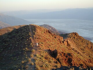
The Panamint Range is a short rugged fault-block mountain range in the northern Mojave Desert, within Death Valley National Park in Inyo County, eastern California. Dr. Darwin French is credited as applying the term Panamint in 1860 during his search for the fabled Gunsight Lode. The orographic identity has been liberally applied for decades to include other ranges.
The Black Mountains are a mountain range located in the southeastern part of Inyo County, California, within southeastern Death Valley National Park.

The Calico Mountains of California are a mountain range located in the Mojave Desert. The range spans San Bernardino and Inyo counties in California.

The Mono Basin is an endorheic drainage basin located east of Yosemite National Park in California and Nevada. It is bordered to the west by the Sierra Nevada, to the east by the Cowtrack Mountains, to the north by the Bodie Hills, and to the south by the north ridge of the Long Valley Caldera.

The Darwin Hills are a mountain range in Inyo County, California, situated near the Argus Range, Panamint Range, and Inyo Mountains. Darwin Falls and the Darwin Falls Wilderness are located in the Darwin Hills. They were named after Dr. Darwin French, a local rancher, miner and explorer. At 6,010 feet (1,832 m), the summit of Ophir Mountain is the highest point of Darwin Hills.
The Kit Fox Hills is a mountain range located in east-central Death Valley National Park in Inyo County, California. The range is situated between the Mesquite Flat Sand Dunes to the west and Grapevine Mountains to the east, along the North Highway, east of Stovepipe Wells and north of Furnace Creek.
The Santa Rosa Hills are a mountain range in the Saline Valley the northern Mojave Desert, in Inyo County, California.

The following outline is provided as an overview of and topical guide to the U.S. state of California:
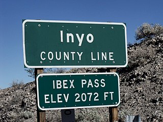
Ibex Pass [el. 2,072 ft (632 m)] is a mountain pass in the Sperry Hills of Central-Southern California in the United States.
The Lost Burro Formation is a Middle to Upper/Late Devonian geologic formation in the Mojave Desert of California in the Western United States.
The Hidden Valley Dolomite is a Silurian−Devonian geologic formation in the northern Mojave Desert of California, in the western United States.
The Mule Spring Limestone is a geologic formation in the Saline Range of eastern California and Split Mountain and Goldfield Hills of Nevada.
The Union Wash Formation is a geologic formation in the Inyo Mountains, east of Lone Pine in Inyo County, California.
The protected areas of the Sierra Nevada, a major mountain range located in the U.S. states of California and Nevada, are numerous and highly diverse. Like the mountain range itself, these areas span hundreds of miles along the length of the range, and over 14,000 feet of elevation from the lowest foothills to the summit of Mount Whitney.

