
In telecommunications, a repeater is an electronic device that receives a signal and retransmits it. Repeaters are used to extend transmissions so that the signal can cover longer distances or be received on the other side of an obstruction. Some types of repeaters broadcast an identical signal, but alter its method of transmission, for example, on another frequency or baud rate.
Southern California is a geographic and cultural region that generally comprises the southern portion of the U.S. state of California. It includes the Los Angeles metropolitan area, the second most populous urban agglomeration in the United States. The region generally contains ten of California's 58 counties: Imperial, Kern, Los Angeles, Orange, Riverside, San Bernardino, San Diego, Santa Barbara, San Luis Obispo and Ventura counties. The Colorado Desert and the Colorado River are located on southern California's eastern border with Arizona, and San Bernardino County shares a border with Nevada to the northeast. Southern California's southern border with Baja California is part of the Mexico–United States border.

ThePacific Coast Ranges, are the series of mountain ranges that stretch along the West Coast of North America from Alaska south to Northern and Central Mexico. Although they are commonly thought to be the westernmost mountain range of the continental United States and Canada, the geologically distinct Insular Mountains of Vancouver Island lie further west.
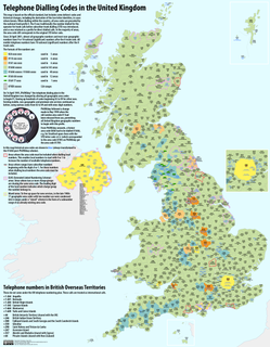
Telephone numbers in the United Kingdom are administered by the Office of Communications (Ofcom). For this purpose, Ofcom established a telephone numbering plan, known as the National Telephone Numbering Plan, which is the system for assigning telephone numbers to subscriber stations.
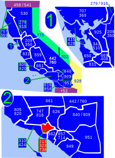
Area codes 213 and 323 are telephone area codes in the North American Numbering Plan (NANP) for the state of California. They are assigned to a numbering plan area (NPA) that comprises, roughly, the area of central Los Angeles, and includes several gateway cities of the region, such as Bell and Huntington Park. The area codes designated separate NPAs since 1998, but were combined in an overlay plan into a single NPA in 2017. Previously, just downtown Los Angeles and immediately adjoining neighborhoods were served by area code 213, and the rest of central Los Angeles used area 323. Area code 213 is one of the original area codes created with the NANP in 1947, and was split five times over the decades.

Area codes 310 and 424 are telephone area codes in the North American Numbering Plan (NANP) for the U.S. State of California. The numbering plan area includes the West Los Angeles and South Bay areas of Los Angeles County, a small portion of Ventura County, and Santa Catalina Island, which is located 26 miles (42 km) south.

Area code 661 is a California telephone area code that covers the majority of California's Kern County, as well as part of Los Angeles County, Santa Barbara County, and Tulare County. It was split from area code 805 on February 13, 1999.
Country Code: +52
International Call Prefix: 469
Trunk Prefix: 01655

Area code 925 is a California telephone area code that was split from area code 510 on March 14, 1998. It covers the inland portions of the East Bay counties of Alameda and Contra Costa in the northern area of California.
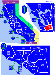
Area codes 408 and 669 are telephone area codes in the North American Numbering Plan (NANP) in the U.S. state of California. The numbering plan area comprises most of Santa Clara County and Northern Santa Cruz County, and includes Gilroy, Morgan Hill, Saratoga, Los Gatos, Monte Sereno, Milpitas, Sunnyvale, Santa Clara, Cupertino, Campbell, and San Jose.

The community of San Antonio Valley, also called San Antonio or San Antone, is located along the Diablo Range in eastern Santa Clara County, California. The locale is bordered by Alameda County to the north and Stanislaus County to the east. The sparsely populated area is located at the junction of San Antonio Valley Road, Mines Road, and Del Puerto Canyon Road. The area includes the San Antonio Valley Ecological Reserve, a 3,282 acre nature preserve created by a Nature Conservancy purchase of land from local rancher, Keith Hurner, and known for its herd of tule elk.

020 is the national dialling code for London in the United Kingdom. All subscriber numbers within the area code consist of eight digits and it has capacity for approaching 100 million telephone numbers. The code is used at 170 telephone exchanges in and around Greater London as part of the largest linked numbering scheme in the United Kingdom. In common with all other British area codes the initial '0' is a trunk prefix that is not required when dialling London from abroad.
Coyote is an unincorporated community in a narrowing of Santa Clara Valley astride Coyote Creek, between San Jose and Morgan Hill's Madrone district, in Santa Clara County, California. Part of Coyote is inside the city limits of San Jose. Its ZIP Code is 95013; there is a small U.S. Post Office. It is inside telephone area codes 408 and 669.

The Landels-Hill Big Creek Reserve is a constituent of the University of California Natural Reserve System. It is located off State Route 1 in the Big Sur area on California's central coast, fifty miles south of Monterey and adjacent to the Big Creek State Marine Reserve and Big Creek State Marine Conservation Area.

Area codes 818 and 747 are California area codes that primarily cover the San Fernando Valley region of Los Angeles County, California.

Iowa Hill is an unincorporated community in Placer County, California, United States. The town is located 6.5 miles northwest of Foresthill 9 miles east of Colfax and 58 miles northeast of Sacramento. It lies at an elevation of 2861 feet. The community relies completely upon solar panels and generators for power. Its population is around 200 people. Iowa Hill Road claims a small handful of lives every decade, and along with the community's "off grid" status, prevents the town from growing in population. The community boasts many hardcore cyclists and is appealing to visitors due to the abundance of recreational opportunities.

Diablo Range is an unincorporated census county division (CCD) located in the Diablo Mountains Range, on the eastern side of Santa Clara County, California.
South Santa Clara Valley is a census county division (CCD) located in south Santa Clara County, California. The area covers approximately 118 square miles (310 km2), and includes the cities of Morgan Hill, San Martin, and Gilroy as well as their immediate outlying unincorporated areas. The area is bounded by Coyote to the north, Llagas-Uvas to the west, Diablo Range to the east, and San Benito County to the south.
