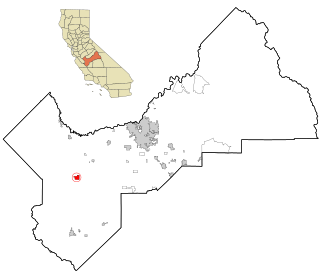
Cantua Creek is a census-designated place (CDP) in Fresno County, California, United States. As of the 2010 census, the population was 466, down from the 655 reported at the 2000 census. Cantua Creek is located 11 miles (18 km) south-southwest of Tranquillity, at an elevation of 295 feet.

The Santa Monica Mountains is a coastal mountain range in Southern California, next to the Pacific Ocean. It is part of the Transverse Ranges. Because of its proximity to densely populated regions, it is one of the most visited natural areas in California. Santa Monica Mountains National Recreation Area is located in this mountain range.

Henry W. Coe State Park is a state park of California, United States, preserving a vast tract of the Diablo Range. The park is located closest to the city of Morgan Hill, and is located in both Santa Clara and Stanislaus counties. The park contains over 87,000 acres (35,000 ha), making it the largest state park in northern California, and the second-largest in the state. Managed within its boundaries is a designated wilderness area of about 22,000 acres (8,900 ha). This is officially known as the Henry W. Coe State Wilderness, but locally as the Orestimba Wilderness. The 89,164-acre (36,083 ha) park was established in 1959.
State Route 33 is a north–south state highway in the U.S. state of California. It runs north from U.S. Route 101 in Ventura through the Transverse Ranges and the western side of the San Joaquin Valley to Interstate 5 at a point east of Tracy. SR 33 replaced part of U.S. Route 399 in 1964 during the "great renumbering" of routes. In the unincorporated sections of Kern County it is known as the West Side Highway. In addition, the California Legislature designated the entire Kern County portion as the Petroleum Highway in 2004. The southernmost portion in Ventura is a freeway known as the Ojai Freeway, while it is known as the Maricopa Highway from Ojai to Maricopa.
The University of California Natural Reserve System (UCNRS) is a system of protected areas throughout California.
Mercey Hot Springs is a resort in the Little Panoche Valley of Fresno County, central California, about 60 miles (97 km) west-southwest of Fresno. It is a resort with cabins, tent and RV campsites, and bathing area along South Fork Little Panoche Creek and the Little Panoche Road located at the western edge of Fresno County.

The Little River is a 4.9-mile-long (7.9 km) river located in central New Hampshire in the United States. Its outflow travels via the Big River, Suncook River, and Merrimack River to the Gulf of Maine, an arm of the Atlantic Ocean.

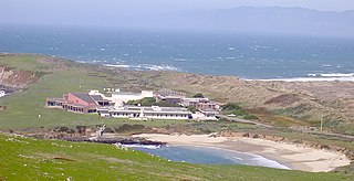
The Landels-Hill Big Creek Reserve is a constituent of the University of California Natural Reserve System. It is located off State Route 1 in the Big Sur area on California's central coast, fifty miles south of Monterey and adjacent to the Big Creek State Marine Reserve and Big Creek State Marine Conservation Area.
The Ciervo Hills are a low mountain range in west Fresno County, in the western San Joaquin Valley of central California.
Rancho Nacional was a 6,633-acre (26.84 km2) Mexican land grant in the Salinas Valley, in present day Monterey County, California given in 1839 by Governor Juan B. Alvarado to Vicente Cantua. The grant was between the Salinas River and present day Salinas.
El Camino Viejo a Los Ángeles, also known as El Camino Viejo and the Old Los Angeles Trail, was the oldest north-south trail in the interior of Spanish colonial Las Californias (1769–1822) and Mexican Alta California (1822–1848), present day California. It became a well established inland route, and an alternative to the coastal El Camino Real trail used since the 1770s in the period.
Cantua Creek, formerly in Spanish Arroyo de Cantúa, was named for José de Guadalupe Cantúa, a prominent Californio Ranchero in the 19th-century Mexican era of Alta California.
Santa Rita Peak is a mountain located in the Diablo Range of California in San Benito County, a short distance to the west of the Fresno County line and 3 miles (5 km) southeast of San Benito Mountain. Cantua Creek has its source on its northern slope. The San Benito River has its source on its southeastern slopes.
Panoche Creek formerly known as Arroyo de Panoche Grande and later anglicized to Big Panoche Creek and later "Panoche Creek". For a time its lower reaches were called "Silver Creek." It is a creek in San Benito County and Fresno County, central California.
La Vereda del Monte was a backcountry route through remote regions of the Diablo Range, one of the California Coast Ranges. La Vereda del Monte was the upper part of La Vereda Caballo,, used by mesteñeros from the early 1840s to drive Alta California horses to Sonora for sale.
Joaquin Ridge is a ridge in the Diablo Range in Fresno County, California. The ridge is named for Joaquin Murietta (1830-1853), a California Gold Rush bandit, leader of the Five Joaquins Gang, who used this region as a rendezvous and camp that overlooked the gangs base at the Rancho de Cantua. The ridge is ten miles long, running from its high point at 36°19′48″N120°34′09″W, east of Spanish Lake, eastward to Joaquin Rocks 36°19′11″N120°27′32″W, and then southwestward to 36°18′15″N120°24′11″W near 3,629 foot Black Mountain at 36°18′16″N120°24′12″W the high point on the south southeast trending Anticline Ridge. Joaquin Ridge is bound on the northeast by the Ragged Valley and the Big Blue Hills and on the southwest by Portuguese Canyon. Its highest elevation is 4,701 feet / 1,433 meters, 0.64 km east of Spanish Lake.

Joaquin Rocks are a group of three pillars of rock, originally known as "Las Tres Piedras", located on Joaquin Ridge, in the Diablo Range, in Fresno County, California. The Joaquin Rocks are at an elevation of 4,121 feet / 1,256 meters, and are the most distinguishing feature of Joaquin Ridge. The three pillars of rock are clearly visible on the ridge for many miles from many directions in the San Joaquin Valley and from their summits have a view of much of the valley. It is located, 3 miles west-northwest of Black Mountain and 3 miles southwest of Ragged Valley.
Ragged Valley is a valley, in the Diablo Range in Fresno County, California. It was named for the ragged appearance of its surface. It is bound on the east by the Big Blue Hills and on the west by Joaquin Ridge. It extends northwesterly from its mouth at Domengine Creek to the divide between Salt Creek and Cantua Creek where it has its head at 36°21′42″N120°25′25″W.
