
Erin Brockovich is an American legal clerk, consumer advocate, and environmental activist, who, despite her lack of education in the law, was instrumental in building a case against the Pacific Gas & Electric Company (PG&E) of California in 1993. Her successful lawsuit was the subject of a 2000 film, Erin Brockovich, which starred Julia Roberts. Since then, Brockovich has become a media personality as well, hosting the TV series Challenge America with Erin Brockovich on ABC and Final Justice on Zone Reality. She is the president of Brockovich Research & Consulting. She also works as a consultant for Girardi & Keese, the New York law firm of Weitz & Luxenberg, which has a focus on personal injury claims for asbestos exposure, and Shine Lawyers in Australia.

Kings County is located in the U.S. state of California. The population was 152,982 at the 2010 census. The California Department of Finance estimated the county's population was 152,940 as of July 1, 2019. The county seat is Hanford.

Buttonwillow is an unincorporated community and census-designated place in the San Joaquin Valley, in Kern County, California. Buttonwillow is 26 miles (42 km) west of Bakersfield, at an elevation of 269 feet (82 m)). The population was 1,508 at the 2010 census, up from 1,266 at the 2000 census. The center of population of California is located in Buttonwillow.

Avenal is a city in Kings County, California, United States. Avenal is located 35 miles (56 km) southwest of Hanford, at an elevation of 807 ft (246 m). It is part of the Hanford–Corcoran Metropolitan Statistical Area, which encompasses all of Kings County. In area, it is the fourth largest city in Kings County. The ZIP Code for this community is 93204, and telephone numbers use the sequence (559) 386-XXXX. The population was 15,505 in the 2010 census, which includes inmates at the Avenal State Prison, the first prison actively solicited by a community in the state of California. Many of the remaining residents largely either work at the prison or in the agriculture industry. The prison provides approximately 1,000 jobs to residents. The California Department of Finance estimated that Avenal's population was 13,496 on July 1, 2019. As of that date, Avenal State Prison held 4,165 inmates, which was about 32% of the total population of Avenal. Inmates are counted as city residents by both the United States Census and the California Department of Finance.

Kettleman City is a census-designated place (CDP) in Kings County, California, United States. Kettleman City is located 28 miles (45 km) southwest of Hanford, 54 miles (88 km) south of Fresno, at an elevation of 253 feet (77 m), and sits only about 1/2 mile north of the 36th parallel north latitude. It is part of the Hanford–Corcoran Metropolitan Statistical Area. The population was 1,439 at the 2010 census, down from 1,499 at the 2000 census. When travelling between Los Angeles and either San Francisco or Sacramento via Interstate 5, Kettleman City is near the halfway point, and is thus a major stopping point for food and lodging.

The Sacramento Valley is the area of the Central Valley of the U.S. state of California that lies north of the Sacramento–San Joaquin River Delta and is drained by the Sacramento River. It encompasses all or parts of ten Northern California counties. Although many areas of the Sacramento Valley are rural, it contains several urban areas, including the state capital, Sacramento.

The Governor Edmund G. Brown California Aqueduct is a system of canals, tunnels, and pipelines that conveys water collected from the Sierra Nevada Mountains and valleys of Northern and Central California to Southern California. Named after California Governor Edmund Gerald "Pat" Brown Sr., the over 400-mile (640 km) aqueduct is the principal feature of the California State Water Project.
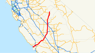
State Route 41 is a state highway in the U.S. state of California, running from the Cabrillo Highway in Morro Bay on the Central Coast to SR 140 in Yosemite National Park, via Fresno and the San Joaquin Valley. It has been constructed as an expressway from near SR 198 in Lemoore north to the south part of Fresno, where the Yosemite Freeway begins, passing along the east side of downtown and extending north into Madera County.

The Diablo Range is a mountain range in the California Coast Ranges subdivision of the Pacific Coast Ranges in northern California, United States. It is stretches from the eastern San Francisco Bay area at its northern end to the Salinas Valley area at its southern end.

The Kettleman North Dome Oil Field is a large oil and gas field in Kings and Fresno counties, California. Discovered in 1928, it is the fifteenth largest field in the state by total ultimate oil recovery, and of the top twenty oil fields, it is the closest to exhaustion, with less than one-half of one percent of its original oil remaining in place.

The Guijarral Hills are a range of low hills in the inner California Coast Ranges, in Fresno County, California, about seven miles east of the town of Coalinga. Guijarral is derived from a Spanish word meaning "heap of pebbles".
The Kreyenhagen Hills are a range of foothills of the Diablo Range in western Fresno County and Kings County, California. The Kreyenhagen Hills form a long foothill belt in the soft formations between Reef Ridge and Kettleman Plain. They are divided into several groups, each a few miles wide, by streams crossing them at right angles. They meet with the steep face of Reef Ridge, and are distinct from the mountains which begin there. To the northeast the strata form ridge after ridge, parallel to each other, and extend the length of the separate divisions between the main stream valleys. These ridges, appear like a series of waves advancing, toward Reef Ridge, and elsewhere to broken waves, as in a choppy sea. The ridges are slightly asymmetric, the northeast flank being a dip slope and fairly smooth, while the southwest flank is a steeper, strike face that is in many places eroded so as to leave sharp gullies and conical intermediate ridges extending outward. The groups of hillocks so produced bear some resemblance to an encampment of tents or huts, and the name Jacalitos,, may have been applied to Jacalitos Creek owing to this feature of the hills through which it flows. The greatest symmetry of the parallel ridges appear's in the portion of the Kreyenhagen Hills between Jacalitos Creek and Big Tar Canyon, and there the long, straight, smooth troughs between the ridges doubtless gave rise to the name Canoas, meaning trough, applied to Canoas Creek which passes across the central portion of the hills. Kreyenhagen was the name of the family who originally owned the land in the area.

The Kettleman Hills Hazardous Waste Facility is a large hazardous waste and municipal solid waste disposal facility, operated by Waste Management, Inc. The landfill is located at 35.9624°N 120.0102°W, 3.5 mi (5.6 km) southwest of Kettleman City on State Route 41 in the western San Joaquin Valley, Kings County, California.
Garza Creek, originally El Arroyo de las Garzas. Its source on the north slope of Zwang Peak of the Diablo Range, in Kings County.
The Anticline Ridge is a ridge, southeast of Joaquin Ridge, declining from its 3,629 foot / 1,106 meter high point, Black Mountain in the north at 36°18′16″N120°24′12″W, to the southeast into low hills bound on the southeast by Los Gatos Creek that divides it from the Guijarral Hills. It is located in the inner California Coast Ranges, in Fresno County, California, east of the town of Coalinga. Anticline Ridge and Guijarral Hills divides Pleasant Valley from the San Joaquin Valley to the east. California State routes 33 and 198, which join together for the stretch through and north of Coalinga, cut across the Coalinga field and cross Anticline Ridge.
Canoas Creek formerly known as Arroyo de Las Canoas is a creek in Fresno County, California. Its source is on the north slope of Black Mountain, 1.25 miles west of Zwang Peak in the Diablo Range. Its course, in its canyon, runs almost directly northeast through Reef Ridge and the Kreyenhagen Hills, from which it flows north northeast into the Kettleman Plain where it turns north northwest 4.6 miles northwest of Avenal near the Kettleman Hills to terminate in the Kettleman Plain, 7.1 miles northwest of Avenal and 3000 feet east of Zapato Chino Creek.
The Casmalia Resources Hazardous Waste Landfill was a 252-acre disposal facility located in the hills near Casmalia, California. During its operation, 4.5 billion pounds of hazardous waste from up to 10,000 individuals, businesses and government agencies were dumped on site. The facility was closed in 1989, and is now a listed as a Superfund Site by the Environmental Protection Agency.
Greenaction for Health and Environmental Justice, formed in 1997, is a multiracial grassroots organization based in San Francisco that works with low-income and working class urban, rural, and indigenous communities. It runs campaigns in the United States to build grassroots networks, and advocate for social justice.
