San Jose Hills

Last updated
San Jose Hills
Relief map of California.png
Red triangle with thick white border.svg
location of San Jose Hills in California [1]
Highest point
PeakBuzzard Peak
Elevation 1,329 ft (405 m)
Geography
CountryUnited States
StateCalifornia
District Los Angeles County
Range coordinates 34°3′33.038″N117°50′33.217″W / 34.05917722°N 117.84256028°W / 34.05917722; -117.84256028
Topo map USGS  San Dimas

The San Jose Hills are a part of the Transverse Ranges in eastern Los Angeles County, California, marking the border between the San Gabriel Valley and the Pomona Valley. It includes portions of Covina, West Covina, Walnut, Pomona, and San Dimas. To the south, the valley of San Jose Creek (a line followed by the Pomona Freeway) separates the San Jose Hills from the Puente Hills and Chino Hills.

Contents

History

The Tongva village of Tooypinga was located at the base of the San Jose Hills. Spanish soldiers, who frequently conducted sweeps of the Los Angeles Basin abducting children to San Gabriel Mission and raping women, destroyed the village prior to 1785 as part of a raid. [2] [3]

Geology

The San Jose Hills are part of the geologic history of Southern California. The San Gabriel Mountains (the Transverse ranges located north of the San Jose Hills) were uplifted by tectonic force as a result of the colliding Pacific and North American plates more than a billion years ago. This tectonic pressure created deeply fractured and fissured sheets of rock that began to shift direction about 25 million years ago. Gradually, a portion of this fissured rock began to uplift from the ocean, forming the Los Angeles Basin. Further folding and fissures helped form other uplifts that include both the San Jose Hills and Puente Hills. These hills, prone to erosion, were formed with their domed appearance while still submerged under water. The San Jose Hills Fault has the possible magnitude of 6.0 to 6.5 and last was active in 1990.

The San Jose Hills' highest point is Buzzard Peak at 1,319 feet (402 m). [4] The highest elevations are composed of conglomerate rock with small, shallow patches of soil. At the bases, silty clay loam dominates. These geologic conditions restrain water absorption towards the rockier higher elevations, which allow runoff to hydrate the base, creating a more habitable (friendly) environment for plants. Because of the transverse (east-west) orientation of the range, this effect is pronounced on the north slope due to the lower rates of evaporation caused by sunlight directed from the south.

Plant communities and wildlife

The San Jose Hills are diverse with unique and rare plant communities. The dominant plant community is coastal sage scrub, known for its high adaptations for long dry summers and is drought deciduous. Prickly-pear cactus can also be found there. Along the northern slopes, especially in the cracks and valleys, one can find pockets of California oak woodland, characterized by coast live oak and Southern California black walnut trees. Southern California black walnut woodlands are increasingly rare and threatened. The largest remaining stands are in the San Jose Hills and Puente Hills to the south.

Mammals, birds, reptiles, and amphibians are very diverse in both the San Jose Hills and surrounding San Gabriel Valley. Mammals in the San Jose Hills include bobcats, coyotes, gray fox, skunks, opossums, squirrels, and other rodents. The bird diversity is exceptional, and notable species include California quail, least Bell's vireo, coastal California gnatcatcher, grasshopper sparrow, southwest willow flycatcher, and red-tailed hawk. Reptiles and amphibians include various lizards and snakes, the California red-legged frog, southwestern arroyo toad, southwestern pond turtle, and other frogs and salamanders.

Culture and recreation

On the most northeastern border, Fairplex (Los Angeles County Fairgrounds) offers an annual L.A. County Fair and other events throughout the year. Fairplex is also the location of both the Los Angeles County Railroad Museum and the Wally Parks NHRA Motorsports Museum. Automotive racing enthusiasts can enjoy adjacent Pomona Raceway-Dragstrip.

Two parks with significant natural areas are located in the eastern portion of the San Jose Hills; Ganesha Park include four picnic pavilions, a community center, amphitheater style band Shell, Olympic size swimming pool with slide, basketball courts, two lighted tennis courts, wildlife and hiking areas, and restroom facilities. Frank G. Bonelli Regional Park has 250-acre (1.0 km2) Puddingstone Reservoir, used for swimming, water skiing, wind surfing, and sailing. The lake is also stocked with trout, bluegill, catfish, and large-mouth bass. Bonelli Park facilities include boat launch ramps, vehicle camp sites, trails for hiking, biking and horseback riding, play equipment, gazebos, and group rental picnic areas.

East of Bonelli Park is Mountain Meadows Golf Course, and on the west, Via Verde Country Club; the latter is south of Walnut Creek Park, a San Dimas city park along Walnut Creek, which drains Puddingstone Reservoir to the west into the San Gabriel Valley.

Several large institutions of higher education are located in the hills. These include California Polytechnic State University, Pomona (Cal Poly Pomona); Mount San Antonio College (Mt. SAC), and Pacific West Bible College. The Voorhis Ecological Reserve in the northwest part of the Cal Poly Pomona campus contains 31 ha of coastal sage scrub and oak woodland. Biotrek is an educational program ran by the Biological Sciences Department. Biotrek includes a Rainforest greenhouse, a native plant garden, aquatic environments, and laboratories. Mt. Sac has a 10-acre (40,000 m2) native Wildlife Sanctuary.

Interment is provided by Forest Lawn Memorial Park and Mortuary. Near the Grand Avenue corridor, Heritage Gardens Historical Park, located on the north slope, was recently redeveloped to include new hiking trails. Walnut Ranch Park can be found on the south slope.

Along Citrus Avenue, one can find South Hills Country Club. Three parks exists along the south slopes: Shadow Oak Park, Creekside Park, and Gingrich Park. On the western portion of the hills is the Industry Hills Recreation Center and smaller Rimgrove and Woodgrove parks. Just east of Azusa Avenue, along the north slopes is Galster Wilderness Park with its new Galster Park Nature Center operated by the San Gabriel Mountains Regional Conservancy and 40 acres (160,000 m2) of Walnut Woodland. The southern slope is West Covina's newest development, Big League Dreams. This mega-sports complex was built on top of a superfund site, the old BKK landfill.

See also

Related Research Articles

<span class="mw-page-title-main">San Dimas, California</span> City in California, United States

San Dimas is a city in the San Gabriel Valley of Los Angeles County, California, United States. At the 2020 census, its population was 34,924. It historically took its name from San Dimas Canyon in the San Gabriel Mountains above the northern section of present-day San Dimas.

<span class="mw-page-title-main">Walnut, California</span> City in California, United States

Walnut is a city in the eastern part of Los Angeles County in the U.S. state of California. According to the 2010 census, the city had a population of 29,172, and the population was estimated to be 29,685 in 2019.

<span class="mw-page-title-main">West Covina, California</span> City in California, United States

West Covina is a city in Los Angeles County, California, United States. Located 19 miles (31 km) east of downtown Los Angeles in the eastern San Gabriel Valley, it is part of Greater Los Angeles. The population for the city was 109,501 at the 2020 census.

<span class="mw-page-title-main">San Gabriel Valley</span> Populated valley in Southern California, United States

The San Gabriel Valley, often referred to by its initials as SGV, is one of the principal valleys of Southern California, with the city of Los Angeles directly bordering it to the west, and occupying the vast majority of the southeastern part of Los Angeles County. Surrounding landforms and other features include the following:

The San Gabriel Valley Tribune is a paid daily newspaper located in Monrovia, California, that serves the central and eastern San Gabriel Valley. It operated at the West Covina location from 1955 to 2015. The Tribune is a member of Southern California News Group, a division of Digital First Media. It is also part of the San Gabriel Valley Newspaper Group, along with the Pasadena Star-News and the Whittier Daily News.

<span class="mw-page-title-main">Pomona Valley</span> Valley in Los Angeles and San Bernardino counties in California

The Pomona Valley is located in the Greater Los Angeles Area between the San Gabriel Valley and San Bernardino Valley in Southern California. The valley is approximately 30 miles (48 km) east of downtown Los Angeles.

<span class="mw-page-title-main">Chino Hills</span> Hill range of the Transverse Ranges in California, United States

The Chino Hills are a mountain range on the border of Orange, Los Angeles, and San Bernardino counties, California, with a small portion in Riverside County. The Chino Hills State Park preserves open space and habitat in them.

<span class="mw-page-title-main">Foothills of the San Gabriel Valley</span>

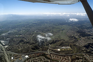
The foothills of the San Gabriel Valley are the foothills and hills in the San Gabriel Valley of eastern Los Angeles County, California. They include the foothills of the San Gabriel Mountains, and independent low mountain ranges of hills, in the east Greater Los Angeles region. The landforms are part of the Transverse Ranges System of Southern California and Baja California.

<span class="mw-page-title-main">Area code 626</span> Area code for the San Gabriel Valley of California

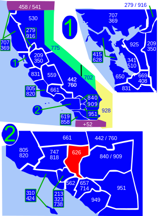
Area code 626 is a telephone area code in the North American Numbering Plan for most of the San Gabriel Valley in the U.S. state of California. The numbering plan area also comprises nearby areas in the northeastern portion of Los Angeles County, California, including Arcadia, Monrovia, El Monte, most of Pasadena and West Covina. The numbering plan area was split from that of area code 818 on June 14, 1997.

<span class="mw-page-title-main">California's 38th congressional district</span> U.S. House district for California

California's 38th congressional district is a congressional district in the U.S. state of California based in suburban eastern Los Angeles County and Orange County, California. The district is currently represented by Democrat Linda Sánchez.

Valley Boulevard is a street in Southern California, running east from Los Angeles to Pomona, where it becomes Holt Avenue, and a continuation from Fontana to Colton. It generally parallels Interstate 10 (I-10) and State Route 60 (CA 60), and is the original alignment of U.S. Route 60 (US 60). The present north end of I-710 is at Valley Boulevard in Los Angeles, just west of Alhambra.

California's 31st congressional district is a congressional district in Los Angeles County, in the U.S. state of California. The district is located in the San Gabriel Valley.

<span class="mw-page-title-main">Puddingstone Reservoir</span> Reservoir in Los Angeles County, California

Puddingstone Reservoir is a 250-acre (1 km²) artificial lake northeast of the interchange between the Orange Freeway and the San Bernardino Freeway in Los Angeles County, California, United States. Activities include fishing, swimming, sailing, windsurfing, and camping. It is fed by Live Oak Wash and drains into Walnut Creek.

The Galster Wilderness Park Nature Center is a small museum and educational center set in Galster Wilderness Park, a 42-acre (170,000 m2) wilderness park located on the north slope of the San Jose Hills in the San Gabriel Valley, California. It is operated by the San Gabriel Mountains Regional Conservancy in partnership with the City of West Covina, California.

The Southern California Association of Governments (SCAG) is the Metropolitan Planning Organization (MPO) of six of the ten counties in Southern California, serving Imperial County, Los Angeles County, Orange County, Riverside County, San Bernardino County, and Ventura County. San Diego County's MPO is the San Diego Association of Governments, which is an unrelated agency.

<span class="mw-page-title-main">Upland–San Bernardino Line</span> Pacific Electric streetcar route (1914–1950)

The Upland–San Bernardino Line was an interurban line operated by the Pacific Electric Railway between Downtown Los Angeles and San Bernardino, California. This line also had shorter service that terminated before the end of the line at Baldwin Park, Covina, and San Dimas. Though service along this line in its entirety was discontinued in November 1941, it stands as the fourth-longest rapid transit line in American history, after the Sacramento Northern Chico and Colusa services, and the Pacific Electric's own Riverside–Rialto Line.

<span class="mw-page-title-main">San Jose Creek</span>

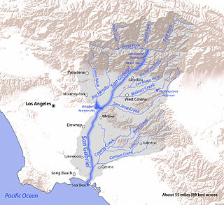
San Jose Creek is an intermittent, tributary stream of the San Gabriel River in Los Angeles County, California. The mouth of San Jose Creek is at an elevation of 194 feet at its confluence with the San Gabriel River, 3.5 miles (5.6 km) southwest of Bassett, California. Its source is at 960 feet near the Los Angeles County Fairplex, at 34°04′50″N117°45′38″W, where it has its confluence with Thompson Wash, actually a continuation of the creek into the San Gabriel Mountains. From Thompson Wash, San Jose Creek flows nearly 20 miles (32 km) westwards from Pomona into the San Gabriel River through the Pomona Valley and San Gabriel Valley. Because of its strategic location between the San Jose Hills and Puente Hills, the Union Pacific Railroad laid tracks along its route connecting Los Angeles with San Bernardino and Salt Lake City.

<span class="mw-page-title-main">Walnut Creek (Southern California)</span>

Walnut Creek is an urban stream in the San Gabriel Valley of Southern California, and is a tributary of the San Gabriel River. The creek begins at the Puddingstone Dam of Puddingstone Reservoir in Frank G. Bonelli Regional Park and flows westward for about 13 miles (21 km), through San Dimas, Covina, West Covina and Baldwin Park, to join the San Gabriel River in El Monte.

<span class="mw-page-title-main">Walnut Islands, California</span> Unincorporated community in California, United States

Walnut Islands or Ramona is an unincorporated area in the eastern part of Los Angeles County in the U.S. state of California. The former is the technical term used by the county government, while the latter was used by the Los Angeles Times in 2008 and the LA Metrolink. One news report referred to the area as Covina Hills. Walnut Islands is surrounded by the cities of Covina and San Dimas to the north, Walnut to the south, West Covina to the west, and Pomona to the east. The population of Ramona was 4,053 according to the 2000 census.

References

  1. "San Jose Hills". Geographic Names Information System . United States Geological Survey, United States Department of the Interior . Retrieved 2009-05-04.
  2. Hernandez, Kelly Lytle (2017). City of inmates : conquest, rebellion, and the rise of human caging in Los Angeles, 1771-1965. Chapel Hill. pp. 16–18, 25. ISBN   978-1-4696-3119-6. OCLC   974947592.{{cite book}}: CS1 maint: location missing publisher (link)
  3. UPPER LOS ANGELES RIVER AND TRIBUTARIES REVITALIZATION PLAN (PDF). 2020. pp. 61–62.
  4. "Buzzard Peak". Geographic Names Information System . United States Geological Survey, United States Department of the Interior . Retrieved 2009-05-04.