
The Santa Clara River is an 83 mi (134 km) long river in Ventura and Los Angeles counties in Southern California. It drains parts of four ranges in the Transverse Ranges System north and northwest of Los Angeles, then flows west onto the Oxnard Plain and into the Santa Barbara Channel of the Pacific Ocean.
The Nature Conservancy (TNC) is a global environmental organization headquartered in Arlington, Virginia. As of 2021, it works via affiliates or branches in 79 countries and territories, as well as across every state in the US.

The Angeles National Forest (ANF) of the U.S. Forest Service is located in the San Gabriel Mountains and Sierra Pelona Mountains, primarily within Los Angeles County in southern California. The ANF manages a majority of the San Gabriel Mountains National Monument.

The San Gabriel River is a mostly-urban waterway flowing 58 miles (93 km) southward through Los Angeles and Orange Counties, California, in the United States. It is the central of three major rivers draining the Greater Los Angeles Area, the others being the Los Angeles River and Santa Ana River. The river's watershed stretches from the rugged San Gabriel Mountains to the heavily-developed San Gabriel Valley and a significant part of the Los Angeles coastal plain, emptying into the Pacific Ocean between the cities of Long Beach and Seal Beach.

The San Bernardino Valley is a valley in Southern California located at the south base of the Transverse Ranges. It is bordered on the north by the eastern San Gabriel Mountains and the San Bernardino Mountains; on the east by the San Jacinto Mountains; on the south by the Temescal Mountains and Santa Ana Mountains; and on the west by the Pomona Valley. Elevation varies from 590 feet (180 m) on valley floors near Chino to 1,380 feet (420 m) near San Bernardino and Redlands. The valley floor is home to over 80% of the more than 4 million people in the Inland Empire region.
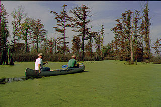
The Cache River is a 92-mile-long (148 km) waterway in southernmost Illinois, in a region sometimes called Little Egypt. The basin spans 737 square miles (1,910 km2) and six counties: Alexander, Johnson, Massac, Pope, Pulaski, and Union. Located at the convergence of four major physiographic regions, the river is part of the largest complex of wetlands in Illinois. The Cache River Wetlands is America's northernmost cypress/tupelo swamp and harbors 91 percent of the state's high quality swamp and wetland communities. It provides habitat for more than 100 threatened and endangered species in Illinois. In 1996, the Cache was designated a Wetland of International Importance under the Ramsar Convention.
The Sierra Nevada Alliance is a network of conservation groups encompassing 24 watersheds of the 650 kilometer-long Sierra Nevada in California and Nevada. Beginning in 1993, the Alliance protects and restores Sierra Nevada lands, watersheds, wildlife and communities.

The California Natural Resources Agency (CNRA) is a state cabinet-level agency in the government of California. The institution and jurisdiction of the Natural Resources Agency is provided for in California Government Code sections 12800 and 12805, et seq. The agency has six departments, 10 conservancies, 17 boards and commissions, three councils, and one urban park in Los Angeles that consists of two museums, the California Science Center and the California African American museum. Through its 25 departments, conservancies and commissions, the Natural Resources Agency is responsible for protecting prehistory history, natural landscapes and cultural sites, monitoring and stewarding state lands and waterways, and regulating fish and game use, as well as private lands and the intersection with federal lands and waters.

TreePeople is an educational and training environmental advocacy organization based in Los Angeles, California. The TreePeople organization advocates and works to support sustainable urban ecosystems in the Greater Los Angeles area through education, volunteer community-based action, and advocacy.
Conserving Carolina is a non-profit conservation organization working to preserve water and land resources in Western North Carolina. Conserving Carolina was created in July 2017, from a merger of two previously separate organizations, Carolina Mountain Land Conservancy and Pacolet Area Conservancy. The combined organization maintains a primary office in Hendersonville, North Carolina, and a regional office in Columbus, North Carolina.
The Council for Watershed Health (CWH) is a nonprofit environmental organization in the U.S. state of California. It was founded in 1996 by Dorothy Green to preserve, restore, and enhance the Los Angeles and San Gabriel River watersheds. To accomplish this, it has brought together representatives from the regional water agencies, as well as government regulatory agencies ; community and environmental citizen groups; and businesses in the Los Angeles Basin watershed.

The Land Conservancy of San Luis Obispo County (LCSLO) is a non-profit land trust organization that has been operating in San Luis Obispo County, California since 1984. The LCSLO is dedicated to voluntary, collaborative preservation, and improvement of lands that hold significant scenic, agricultural, habitat, and cultural values. Their work aims to benefit both local communities and wildlife.
Antelope Valley Conservancy is a public-benefit corporation that preserves natural habitats and watershed resources. It was founded 2005, granted 501(c)(3) and 170(b)(1)(a)(vi) tax status in 2006, absorbed the Antelope Valley Trails Recreation and Environmental Council (AVTREC) in 2007, and earned authorization from the California Department of Fish and Game to hold mitigation lands in 2008.
A sustainability organization is (1) an organized group of people that aims to advance sustainability and/or (2) those actions of organizing something sustainably. Unlike many business organizations, sustainability organizations are not limited to implementing sustainability strategies which provide them with economic and cultural benefits attained through environmental responsibility. For sustainability organizations, sustainability can also be an end in itself without further justifications.
The West Fork Conservancy is a 501(c)(3) non-profit volunteer organization which collects, bags, and hauls trash and human waste out of the San Gabriel River located within the Angeles National Forest of the San Gabriel Mountains. The Conservancy also removes Graffiti, assists in extinguishing illegal camp fires and cooking fires, and performs whatever other tasks that the United States Forest Service requests of the organization.
The Georgia Conservancy is an American non-profit environmental organization in the U.S. state of Georgia that collaborates, advocates, and educates to protect Georgia's natural environment. It was founded in 1967. Called "the state's most influential environmental organization" by Georgia Trend magazine, the Georgia Conservancy focuses on environmental advocacy, land conservation, coastal protection, stream protection, outdoor recreation, stewardship, and growth management. Its mission is: “To protect Georgia's natural resources for present and future generations by advocating sound environmental policies, advancing sustainable growth practices and facilitating common-ground solutions to environmental challenges.”

The San Gabriel and Lower Los Angeles Rivers and Mountains Conservancy (RMC) is an agency of the State of California in the United States with the mission of preserving open space and habitat for low-impact recreation and educational uses, wildlife habitat restoration and protection, and watershed improvements within its jurisdiction. The conservancy was created by the state legislature in 1999, and is headquartered in Azusa. It is 1 of 10 conservancies within the California Natural Resources Agency. At the time of its founding, it was the state's first conservancy to primarily serve an urban area.