
Buena Vista is an independent city located in the Blue Ridge Mountains region of Virginia in the United States. As of the 2020 census, the population was 6,641. The Bureau of Economic Analysis combines the independent cities of Buena Vista and Lexington, along with surrounding Rockbridge County, for statistical purposes.

Buena Vista is a Statutory Town located in Chaffee County, Colorado, United States. The town population was 2,855 at the 2020 United States Census.

Salida is the statutory city that is the county seat and the most populous municipality of Chaffee County, Colorado, United States. The population was 5,666 at the 2020 census.

Lake Buena Vista is a city in Orange County, Florida, United States. It is mostly known for being the mailing address for Walt Disney World, although almost all of the resort facilities, including all four theme parks, are physically located in the adjacent city of Bay Lake. It is one of two Florida municipalities inside the Central Florida Tourism Oversight District, which also contains Walt Disney World, the other being Bay Lake. The permanent residential population of Lake Buena Vista was 24 at the 2020 census.

Buena Vista is a city in Marion County, Georgia, United States. It is part of the Columbus, Georgia-Alabama metropolitan statistical area. The population was 1,585 at the 2020 census, down from 2,173 in 2010. Formerly known as "Pea Ridge", the city changed its name to Buena Vista in honor of Zachary Taylor's victory in the Mexican–American War. The city is the county seat of Marion County. It is the birthplace of baseball legend Josh Gibson and Medal of Honor recipient Luther H. Story.
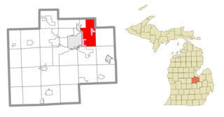
Buena Vista Charter Township is a charter township of Saginaw County in the U.S. state of Michigan. Per the 2020 census, the population was 7,664.
Buena Vista is a census-designated place in Amador County, California. It lies at an elevation of 295 feet. It is located 4 miles (6.4 km) south-southeast of Ione, at 38°17′40″N120°54′48″W. The community is in ZIP code 95640 and area code 209. The population was 429 at the 2010 census.

An estancia or estância is a large, private plot of land used for farming or raising cattle or sheep. Estancias are located in the southern South American grasslands of Chilean and Argentine Patagonia, while the pampas, have historically been estates used to raise livestock, such as cattle or sheep. In Puerto Rico, an estancia was a farm growing frutos menores; that is, crops for local sale and consumption, the equivalent of a truck farm in the United States. In Chile and Argentina, they are large rural complexes with similarities to what in the United States is called a ranch.

The ornate shrew is a species of mammal in the family Soricidae (shrews). It is endemic to western North America, ranging from Northern California in the United States to the Baja California peninsula in Mexico. Eight subspecies are known, including the extinct tule shrew, known only from four specimens collected in 1905, and the Suisun ornate shrew, a species of conservation concern in California. Through skull morphology research and genetic testing on Ornate shrew populations, it has been shown that there are three main genetic subdivisions: The Southern, Central and Northern. These three genetic subdivisions of Ornate shrew arose from populations of Ornate shrews getting geographically isolated from other populations.
Buena Vista is an unincorporated community in Polk County, Oregon, United States. It is located on the Willamette River, and is the western landing for the Buena Vista Ferry. It is approximately 7 miles (11 km) south-southeast of Independence.

The Buena Vista Oil Field, formerly the Naval Petroleum Reserve No. 2 (NPR-2) is a large oil field in Kern County, San Joaquin Valley, California in the United States. Discovered in 1909, and having a cumulative production of approximately 667 million barrels (106,000,000 m3), it is the tenth-largest oil field in California. As of year end 2006 the field had a total reserve of only about one percent of its original oil, and having produced a mere 713,000 barrels (113,400 m3). Since, the field has gone through a revitalization. Crimson Resources initiated a waterflood in the Etchegoin Formation, saw good response and sold the asset to Occidental Petroleum. CRC continued the development of the waterflood, but also tested the viability of the Monterey Formation. The Monterey Formation at Buena Vista has proven to be a viable target and is currently being developed.
Buena Vista is an unincorporated community in Elizabeth Township, Allegheny County, Pennsylvania, United States, located just outside Pittsburgh on the Youghiogheny River. The Great Allegheny Passage rail trail runs through the community. Buena Vista was laid out in 1849 by James B. McGrew for the heirs of Daniel Greenawalt. For a time, it served as a mining town. Like many places in the US with this name, Buena Vista was named for the 1847 Battle of Buena Vista during the Mexican–American War.
The Buena Vista Hills are a low mountain range in the Peninsular Ranges System, in western San Diego County, California.

Magueyes is one of the 31 barrios of the municipality of Ponce, Puerto Rico. Together with Cerrillos, Machuelo Arriba, Maragüez, Montes Llanos, Portugués, Sabanetas, and Tibes, Magueyes is one of the municipality's eight interior barrios. The name of this barrio is of native Indian origin. It was created in 1831.
The Buena Vista Mine is located 21 miles (34 km) southeast of Lovelock, Nevada. In the past, the area has been known as the Mineral Basin, though another name for the area has been the Buena Vista District. There are at least two other Buena Vista Mining Districts in Nevada; one is located near Unionville, Nevada, and the other is located in Esmeralda and Mineral counties near the California border. The nearby Buena Vista Hills are named for the mine. The district encompasses roughly 21 square miles (54 km2) of mineral and surface rights, and is one of the largest un-mined iron ore resources in the western United States.

This is a list of the National Register of Historic Places listings in Buena Vista, Virginia.
Buena Vista is an unincorporated community located along Richland Creek in Stephenson County, Illinois at latitude 42.426 and longitude -89.678. The elevation is 797 feet. Buena Vista is in Orangeville Community School District. The Jane Addams bike trail passes through Buena Vista.

Buena Vista Lagoon is a freshwater lagoon adjacent to the Pacific Ocean in the South Coast region of Southern California within North County, San Diego County.

Emerald Peak is a high mountain summit of the Collegiate Peaks in the Sawatch Range of the Rocky Mountains of North America. The 13,911-foot (4,240 m) thirteener is located in the Collegiate Peaks Wilderness of San Isabel National Forest, 14.7 miles (23.7 km) west-northwest of the Town of Buena Vista in Chaffee County, Colorado, United States.
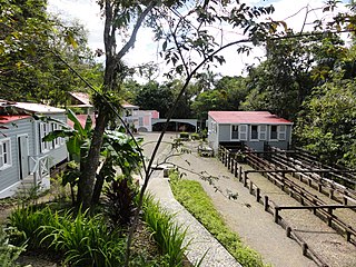
Museo Hacienda Buena Vista is a historic coffee plantation farm museum in Barrio Magueyes, Ponce, Puerto Rico. The museum opened in 1987, and receives some 40,000 visitors a year. The museum has been described as "Puerto Rico's first living museum of art and science."

