West Coyote Hills

Last updated
West Coyote Hills
Cliffs in Coyote Hills, Fullerton, CA, seen from Ralph B. Clark Park.jpg
cliffs in Coyote Hills
Highest point
Elevation 184 m (604 ft)
Geography
Relief map of California.png
Red triangle with thick white border.svg
location of West Coyote Hills in California [1]
CountryUnited States
StateCalifornia
District Orange County
Range coordinates 33°54′19.050″N117°57′44.224″W / 33.90529167°N 117.96228444°W / 33.90529167; -117.96228444
Topo map USGS  La Habra

The West Coyote Hills is the area surrounding a ridge in northern Orange County, California. [1] It contains one of the last large open-space area in north Orange County. Parts of it lie within the city limits of La Habra, Buena Park, and La Mirada, with most of it sprawling across western Fullerton between Ralph B. Clark Regional Park and Euclid Street north of Rosecrans Avenue. The foothill region to the east and south is known as Sunny Hills. [2] There is also an East Coyote Hills area, on the east side of Fullerton, that has been almost completely developed for residential real estate.

Contents

The remaining open-space area is currently the subject of a long-running dispute over residential development, pitting conservationists against a pro-development majority on the city council. A division of Chevron is currently proposing to develop the portions of the land that are suitable for development, while leaving the remainder as open space.

Name

The hills received their name from the nearby Rancho Los Coyotes; by the 1870s they were being called Coyote Hills. [3] The name is appropriate, since coyotes do inhabit the area.

Development

The West Coyote Hills was once a major oil field, dating back to 1890. [4] Extraction has long since ceased, and most of the West Coyote Hills has been developed for residential and commercial use, as well as West Coyote Hills Park.

A tract measuring 510 acres (2.1 km2) across the ridge of the hills, owned by Pacific Coast Homes (a land development division of the Chevron Corporation), is the largest remaining tract of undeveloped land in north Orange County. Pacific Coast Homes plans to build 760 homes on 179 acres (0.72 km2), while restoring and donating 352 acres to the City of Fullerton for use as the Robert E. Ward Nature Preserve. [5] A group called Open Coyote Hills has been leading the support [6] while a group called Friends of Coyote Hills has led the push to preserve the entire site as open space. [7]

In 2012, Fullerton voters voted to prevent development in a referendum, Measure W. [8] Lawsuits have resulted over the interpretation of the measure. The city council has a pro-development majority, which has sided with Chevron, [9] and won in Superior Court, but the decision has been appealed. In 2017, State Senator Josh Newman authored Senate Bill 714, which would prevent development. [10] Efforts have been made to buy some or all of the land from Chevron, using state funds, donations, or both.

Eucalyptus trees and buckwheat in a meadow in Coyote Hills. Meadow in Coyote Hills, Fullerton, CA.jpg
Eucalyptus trees and buckwheat in a meadow in Coyote Hills.

Plant life

The undeveloped areas of Coyote Hills are vegetated with coastal sage scrub. [11] [12] Native species include buckwheat and prickly pear. Nonnative plants include pepper trees, tobacco trees, and mustard. There are no creeks, except for ephemeral freshets after storms, and no native riparian species such as oaks. Mature eucalyptus trees and some pine trees grow along some of the fence lines, where the area abuts housing tracts and the city's trail system.
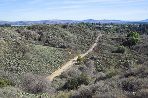
Topography

The area has been modified by large earth-moving projects to reduce the number of steep hills and canyons, allowing Gilbert Street to be constructed and real estate developments and later a golf course to be built on the west side of Gilbert. East of Gilbert Street, the undeveloped area consists mainly of a large, sun-exposed, gentle north-facing slope. The larger area west of Gilbert contains rugged terrain, predominantly south-facing slopes, and a large, long, dry, flat-bottomed canyon that runs north-south. The canyon bottom has been paved, and provides a fire road accessible from the nearby fire station on Rosecrans Avenue. The steep sides of the canyon were terraced and networked with asphalt roads for oil drilling. Impressive cliffs are a landmark visible to motorists on Rosecrans Avenue.

Prickly pear on an east-facing slope near Euclid Street, viewed from the Fullerton Loop. Coyote-Hills-Fullerton.jpg
Prickly pear on an east-facing slope near Euclid Street, viewed from the Fullerton Loop.

Fossils

U.S. Geological Survey researchers have found invertebrate fossils representing 184 taxa from 158 localities in the "San Pedro" Formation in the Coyote Hills, including various species of annelids, mollusks, arthropods, and echinoids; the fossils suggest a late Pliocene to early Pleistocene age for outcrops of the formation. The occurrence of the bivalve Solamen columbianum in the area marks its first occurrence as a fossil. The oldest fossil occurrence of the gastropods Tegula pulligo (Gmelin), questionably Haliotis cracherodii, and the crustacean Randallia ornata occur in the "San Pedro" Formation in the Coyote Hills. [13]

Hillside heavily forested with pepper trees. Hillside forested with pepper trees in Coyote Hills, Fullerton, CA.jpg
Hillside heavily forested with pepper trees.

Risner fire

A brush fire, the Risner fire, originated at a transient encampment in the area. It burned about 80 acres on September 8 and 9, 2015, prompting the evacuation of about 40 nearby homes. [14]

See also

Related Research Articles

<span class="mw-page-title-main">Fullerton, California</span> City in California, United States

Fullerton is a city located in northern Orange County, California, United States. As of the 2020 census, the city had a total population of 143,617.

<span class="mw-page-title-main">Laguna Niguel, California</span> City in California, United States

Laguna Niguel is a city in Orange County, California, United States. The name Laguna Niguel is derived from the words "Laguna" and "Niguili". As of the 2020 census, the population was 64,355. Laguna Niguel is located in the San Joaquin Hills in the southeastern corner of Orange County, close to the Pacific Ocean, and borders the cities of Aliso Viejo, Dana Point, Laguna Beach, Laguna Hills, Mission Viejo, and San Juan Capistrano.

<span class="mw-page-title-main">East Bay Regional Park District</span>

The East Bay Regional Park District (EBRPD) is a special district operating in Alameda County and Contra Costa County, California, within the East Bay area of the San Francisco Bay Area. It maintains and operates a system of regional parks which is the largest urban regional park district in the United States. The administrative office is located in Oakland.

<span class="mw-page-title-main">Claremont Canyon Regional Preserve</span>

Claremont Canyon Regional Preserve is a small regional park mainly located in the city of Oakland, California, and administered by the East Bay Regional Park District. The park is named for the canyon in which it is situated, Claremont Canyon, out of which Claremont Creek flows on its way to its confluence with Temescal Creek. Originally, the canyon was named Harwood's Canyon, and then later as Telegraph Canyon. The name was changed to Claremont by a developer of the nearby Claremont district.

Porter Ranch is a suburban neighborhood in the northwest San Fernando Valley region of the City of Los Angeles, California.

<span class="mw-page-title-main">Henry W. Coe State Park</span> State park in California, U.S.

Henry W. Coe State Park is a state park of California, United States, preserving a vast tract of the Diablo Range. The park is located closest to the city of Morgan Hill, and is located in both Santa Clara and Stanislaus counties. The park contains over 87,000 acres (35,000 ha), making it the largest state park in northern California, and the second-largest in the state. Managed within its boundaries is a designated wilderness area of about 22,000 acres (8,900 ha). This is officially known as the Henry W. Coe State Wilderness, but locally as the Orestimba Wilderness. The 89,164-acre (36,083 ha) park was established in 1959.

<span class="mw-page-title-main">Glen Canyon Park</span> Park in San Francisco, California, USA

Glen Canyon Park is a city park in San Francisco, California. It occupies about 70 acres (28 ha) along a deep canyon adjacent to the Glen Park, Diamond Heights, and Miraloma Park neighborhoods. O'Shaughnessy Hollow is a rugged, undeveloped 3.6 acres (1.5 ha) tract of parkland that lies immediately to the west and may be considered an extension of Glen Canyon Park.

<span class="mw-page-title-main">Silverado, California</span> Unincorporated community in Orange County, California, United States

Silverado is an unincorporated community in Silverado Canyon, which is located in the Santa Ana Mountains in eastern Orange County, California. Portions of the town sit on a former Mexican land grant Rancho Lomas de Santiago. Silverado is located at the boundaries of Cleveland National Forest. The site is a California Historical Landmark, and is located near the village site of Puhú.

<span class="mw-page-title-main">Middleton Tract, California</span> Unincorporated community in California, United States

Middleton Tract is a rural community in the coastal Redwoods of San Mateo County, California. Unattributed press reports say the name Middleton Tract may have been applied to this area as early as 1925. In the present day, the name is official at the county government level. It appears on County Assessor's maps including County of San Mateo, Master Index Map, Revision 2, June, 1985,, page 40–41.

Ralph B. Clark Regional Park is an urban park located in the cities of Fullerton and Buena Park, California. The park is maintained by Orange County Regional Parks, the government division that controls the regional parks in Orange County. The park is south of Rosecrans Avenue at the southern edge of the West Coyote Hills in Buena Park, but both a small section named Camel Hill next to the main park area south of Rosecrans and another small section of the park with six softball fields and a trail located north of Rosecrans Avenue are within Fullerton city limits. The park was originally opened as Los Coyotes Regional Park in 1981, and was renamed in 1987 after then-retiring Orange County Supervisor Ralph B. Clark (1917–2009).

<span class="mw-page-title-main">Anaheim Hills</span> Planned community in Anaheim in California, United States

Anaheim Hills is a planned community encompassing the eastern portions of the city of Anaheim, in Orange County, California.

<span class="mw-page-title-main">San Clemente Canyon</span>

San Clemente Canyon is a canyon located in the city of San Diego, in San Diego County, California.
Marian Bear Memorial Park, a linear open space park, is along the canyon and in the southern tributary arroyos and mesa.

<span class="mw-page-title-main">Laguna Canyon</span> Canyon in Tongva Territory, United States of America

Laguna Canyon, also called Cañada de las Lagunas, is a gorge that cuts through the San Joaquin Hills in southern Orange County, California, in the United States, directly south of the city of Irvine. The canyon runs from northeast to southwest, and is drained on the north side by tributaries of San Diego Creek and on the south by Laguna Canyon Creek. It is deeper and more rugged on the southwestern end near Laguna Beach.

<span class="mw-page-title-main">Rosecrans Avenue</span> Street in Los Angeles

Rosecrans Avenue is a major west-east thoroughfare in Los Angeles and Orange Counties, California, USA. It has a total length of 27.5 miles (44.3 km). The street is named after U.S. Union General William S. Rosecrans, who purchased 13,000 acres (5,300 ha) of Rancho Sausal Redondo southwest of Los Angeles in 1869. Rosecrans Avenue was originally named Drexel Avenue, and ran through the Rosecrans Rancho which is part of modern-day Gardena.

<span class="mw-page-title-main">Coyote Creek (San Gabriel River tributary)</span> Tributary of the San Gabriel River in California

Coyote Creek is a principal tributary of the San Gabriel River in northwest Orange County, southeast Los Angeles County, and southwest Riverside County, California. It drains a land area of roughly 41.3 square miles (107 km2) covering eight major cities, including Brea, Buena Park, Fullerton, Hawaiian Gardens, La Habra, Lakewood, La Palma, and Long Beach. Some major tributaries of the creek in the highly urbanized watershed include Brea Creek, Fullerton Creek, and Carbon Creek. The mostly flat creek basin is separated by a series of low mountains, and is bounded by several small mountain ranges, including the Chino Hills, Puente Hills, and West Coyote Hills.

<span class="mw-page-title-main">Laguna Coast Wilderness Park</span>

Laguna Coast Wilderness Park is a 7,000-acre (2,800 ha) wilderness area in the San Joaquin Hills surrounding Laguna Beach, California. This park features coastal canyons, ridgeline views and the only natural lakes in Orange County, California. Trails are maintained for hiking and mountain biking with a wide range of difficulty, from beginner to expert. Most trails gain in height, reaching a maximum of 1,000 feet (300 m) in elevation. Several trails lead to downtown Laguna Beach.

<span class="mw-page-title-main">Peters Canyon</span> Valley in California, United States of America

Peters Canyon Regional Park is a regional park within the Orange County Regional Parks System in California. The park contains 354 acres of southern California wildlife, including coastal sage shrub, riparian, freshwater marsh, and grasslands, and is located within the boundaries of both Orange, California and Tustin, California. Peters Canyon was given to this city in 1992 by the Irvine Company who had used it previously for cattle grazing. The canyon is lined with a residential area on one side and open hills on the other. This canyon is commonly used by hikers, mountain bikers, and equestrians because of the trails that circumvent the 50 acre man-made lake, which was constructed by the Irvine Company in 1931, on the interior of the plot. The regional park is open from 7:00 AM to sunset every day of the week, save for the chance of rain or hazardous conditions, in which case the park will be closed for three days following the particular occurrence.

<span class="mw-page-title-main">Arroyo Conejo Open Space</span> Park in Ventura County, California, United States of America

Arroyo Conejo Open Space is a 302-acre (122 ha) open space reserve in the western Simi Hills in northern Newbury Park, Ventura County, California. Most of it is part of the 250-acre (100 ha) Arroyo Conejo Nature Preserve.

<span class="mw-page-title-main">Carbon Canyon Regional Park</span> Park in Orange County, California

Carbon Canyon Regional Park is a regional park in Brea, California, that was created after the Carbon Canyon Creek was dammed. It links up with Chino Hills State Park on the east side. The park also is home to a small forest of Redwood trees, which have been struggling to survive since the start of the 2010 California drought.

<span class="mw-page-title-main">Whiting Ranch Wilderness Park</span> Park in Orange County, California

Whiting Ranch Wilderness Park is a public regional park in southern Orange County, California. Whiting Ranch features riparian, oak woodland, grassland, chaparral, and coastal sage scrub environments throughout various canyons and hillscapes. The 2,500-acre park mostly encompasses unincorporated land just outside of Lake Forest. The park is home to over 17 miles of trail spread out over 23 different paths, making the location a popular destination for mountain bikers, hikers, and horseback riders.

References

  1. 1 2 "West Coyote Hills". Geographic Names Information System . United States Geological Survey, United States Department of the Interior . Retrieved 2009-05-04.
  2. Dodero, Tony (August 29, 2004). "In Fullerton hills, life slows to a trot". Los Angeles Times. Archived from the original on January 27, 2013.
  3. Brigandi, Phil (2006). Orange County place names, A to Z. San Diego: Sunbelt Publications.
  4. Hicks, Jerry (May 6, 2001). "Fullerton Group Will Oppose Development of Coyote Hills". pp. B4.
  5. "West Coyote Hills: New Homes and Natural Open Space in Fullerton". westcoyotehills.com. Archived from the original on 2006-08-22.
  6. "Home". opencoyotehills.com.
  7. Carpenter, Eric (April 10, 2006). "West Coyote Hills housing plan stirs debate". The Orange County Register.
  8. "Fullerton's Open Space Battle Still Ongoing," Voice of OC, March 31, 2016, https://voiceofoc.org/2016/03/fullertons-open-space-battle-still-ongoing/
  9. "City of Fullerton - West Coyote Hills Specific Plan". www.cityoffullerton.com. Archived from the original on 2015-03-11.
  10. "Fullerton Observer". www.fullertonobserver.com. Archived from the original on 2017-10-22.
  11. Schad, Afoot and afield in Orange County, Wilderness Press, 1996, p. 5
  12. Schoenherr, Wild and beautiful: a natural history of open spaces in Orange County
  13. Powell, Charles L. II & Stevens, Dave (2000). "Age and Paleoenvironmental Significance of Mega-Invertebrates from the "San Pedro" Formation in the Coyote Hills, Fullerton and Buena Park, Orange County, Southern California" (PDF). United States Geological Survey. Open-File Report 00-319.{{cite journal}}: Cite journal requires |journal= (help)
  14. Serna, Joseph (September 9, 2015), "Brush fire in Orange County fully contained as evacuations lifted", Los Angeles Times, retrieved December 14, 2017