
A panorama is any wide-angle view or representation of a physical space, whether in painting, drawing, photography, film, seismic images or a three-dimensional model. The word was originally coined in the 18th century by the English painter Robert Barker to describe his panoramic paintings of Edinburgh and London. The motion-picture term panning is derived from panorama.

ThePacific Coast Ranges, are the series of mountain ranges that stretch along the West Coast of North America from Alaska south to Northern and Central Mexico.

Mission Hills is an urban residential community of the San Fernando Valley, within the city of Los Angeles, California.

The San Fernando Valley is an urbanized valley in Los Angeles County, California, in the Los Angeles metropolitan area, defined by the mountains of the Transverse Ranges circling it. Home to 1.77 million people, it is north of the larger, more populous Los Angeles Basin.

Panorama City is a neighborhood in the city of Los Angeles, California, in the San Fernando Valley. It has a generally young age range as well as the highest population density in the Valley. Ethnically, more than half the population was born abroad, a higher percentage than Los Angeles as a whole. Known as the valley's first planned community following a transition from agriculture to a post-World War II housing boom, it has produced several notable residents. Today it is a mixture of single-family homes and low-rise apartment buildings. Panorama City has three high schools, two recreational centers, a senior center, two hospitals and a chamber of commerce.

Franz Roubaud was a Russian painter who created some of the largest and best known panoramic paintings. He created circular paintings, exposed on a cylindrical surface and viewed from the inside at a lookout point. The painting was believed to reproduce the original scene with high fidelity.
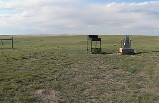
Panorama Point also known as Constable Mountain, is the highest natural point in Nebraska, at an elevation of 5,429 feet (1,655 m) above sea level. It is located in southwestern Kimball County, near the point where Nebraska and Wyoming meet on Colorado's northern boundary. Despite its name and elevation, Panorama Point is not a mountain or a hill; it is merely a low rise on the High Plains. A stone marker, giving the elevation at 5,424 feet (1,653 m), and a guest register are located at the summit of the drive. From the point one can see the nearby state corner marker, and a vast plains landscape with the Rocky Mountains in the western distance. Panorama Point is located on the High Point Bison Ranch, which permits visitors to drive to the site as long as they take care to avoid the ranging bison and pay an entrance fee.

Aran Fawddwy is a mountain in southern Snowdonia, Wales, United Kingdom. It is the highest point of the historic county of Merionethshire. It is the only peak in Wales outside North Snowdonia above 900m, and higher than anywhere in Great Britain outside Northern Snowdonia, the Scottish Highlands and the Lake District. The nearest urban centres to the mountain are Dinas Mawddwy to the south, Llanymawddwy to the southeast, Llanuwchllyn on the shores of Bala Lake to the north, and Rhydymain to the west. The nearest settlements with around 2,000 people are Bala and Dolgellau. On the eastern slopes of Aran Fawddwy is the small lake named Creiglyn Dyfi, the source of the River Dyfi. Its sister peak is Aran Benllyn at 885 metres (2,904 ft). There is also a middle peak- Erw y Ddafad-ddu.

Panorama Mountain Resort is a ski and golf resort in Canada, located in the Purcell Mountains of southeastern British Columbia. Part of the Columbia Valley sub-region of the East Kootenay region, it is a tourist destination known for its rolling cliffs and views of the Rocky Mountains. It is privately owned by Panorama Mountain Village Inc.

Andy Narell is an American jazz steel pannist.

Askival is the highest mountain on the island of Rùm, in the Inner Hebrides of Scotland. It is located 5 kilometres (3.1 mi) south of Kinloch, the main village on the island. It is part of the Rùm Cuillin, a rocky range of hills in the southern end of Rùm. It is often climbed as part of a full traverse of the ridge.

Devore Heights, or Devore, is a rural and mountainous neighborhood in San Bernardino, California. It is located just north of the junction of Interstate 15 and Interstate 215, about 12 miles northwest of downtown San Bernardino. It is also the last town to pass through before taking the Cajon Pass to reach Hesperia, California. The area is just outside the boundaries of the San Bernardino National Forest; nearby cities and communities include Verdemont, University Hills, Rancho Cucamonga, Fontana, and Rialto. Glen Helen Pavilion/Amphitheater, the largest amphitheater in North America, is located just south of Devore. Devore is completely within the city's 92407 ZIP Code and is within the 909 area code as well. Devore is served by the San Bernardino City Unified School District. Devore is home to Kimbark Elementary, a 2016 California Gold Ribbon School. While no middle or high schools are located within the neighborhood, the nearby neighborhoods of Verdemont and University Hills have a middle school and high school, respectively. Kimbark School opened in 1968. It was preceded by Cajon School just south of Devore Road on Cajon Blvd. Cajon School, one large room that could be divided into two by a sliding wall, was built in 1924 of native rocks by residents of Devore on land donated by R. B. Peters, one of the community's most illustrious residents. A four room wing was added in 1949 to accommodate students through sixth grade. That Cajon School was preceded by an earlier one on the other side of Cajon Blvd. which functioned from 1870 to 1921, when the Cajon School District was annexed by San Bernardino.
James Monroe High School (JMHS) is a high school in the North Hills area of Los Angeles, California, belonging to the Los Angeles Unified School District. The school is located at 9229 Haskell Avenue, North Hills, CA 91343. It is home to Small Learning Communities (SLCs) and two magnet schools. The school's mascot is the Viking.

Panorama Hills is a suburban residential neighbourhood in the northwest quadrant of Calgary, Alberta. It is a new community, located at the northern edge of the city, north of Country Hills boulevard.
Panorama Hills may refer to:

The Landels-Hill Big Creek Reserve is a constituent of the University of California Natural Reserve System. It is located off State Route 1 in the Big Sur area on California's central coast, fifty miles south of Monterey and adjacent to the Big Creek State Marine Reserve and Big Creek State Marine Conservation Area.

Northeast Bakersfield is the northeast region of Bakersfield, California. It is roughly bounded by Panorama Drive and the Kern River to the north, Alfred Harrell Highway/Comanche Drive to the east, Edison Highway to the south, and Union Avenue to the west. The region of East Bakersfield is located within these boundaries but is usually not considered part of the Northeast. Instead, the Northeast wraps around the boundaries of East Bakersfield. Other boundaries are the city limits.
