Poverty Hills

Last updated
Poverty Hills
Relief map of California.png
Red triangle with thick white border.svg
location of Poverty Hills in California [1]
Highest point
Elevation 1,389 m (4,557 ft)
Geography
Country United States
State California
District Inyo County
Range coordinates 37°2′59.759″N118°14′57.358″W / 37.04993306°N 118.24926611°W / 37.04993306; -118.24926611 Coordinates: 37°2′59.759″N118°14′57.358″W / 37.04993306°N 118.24926611°W / 37.04993306; -118.24926611
Topo map USGS  Tinemaha Reservoir

The Poverty Hills are a mountain range in northwestern Inyo County of eastern California, northwest of Bishop and the upper Owens Valley. [1]

Inyo County, California County in California, United States

Inyo County is a county in the U.S. state of California. As of the 2010 census, the population was 18,546. The county seat is Independence.

California State of the United States of America

California is a state in the Pacific Region of the United States. With 39.6 million residents, California is the most populous U.S. state and the third-largest by area. The state capital is Sacramento. The Greater Los Angeles Area and the San Francisco Bay Area are the nation's second- and fifth-most populous urban regions, with 18.7 million and 9.7 million residents respectively. Los Angeles is California's most populous city, and the country's second-most populous, after New York City. California also has the nation's most populous county, Los Angeles County, and its largest county by area, San Bernardino County. The City and County of San Francisco is both the country's second-most densely populated major city after New York City and the fifth-most densely populated county, behind only four of the five New York City boroughs.

Bishop, California City in California, United States

Bishop is a city in Inyo County, California, United States. Though Bishop is the only incorporated city and the largest populated place in Inyo County, the county seat is located in Independence. Bishop is located near the northern end of the Owens Valley, at an elevation of 4,150 feet (1,260 m). The town was named after Bishop Creek, flowing out of the Sierra Nevada; the creek was named after Samuel Addison Bishop, a settler in the Owens Valley. Located near numerous tourist attractions, Bishop is a major resort town; the town is a commercial and residential center, while many vacation destinations in the Sierra Nevada are located nearby.

They are east of and below the Sierra Nevada, in the Round Valley area, and just west of Tinemaha Reservoir and the Owens River.
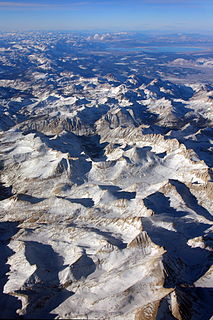
Sierra Nevada (U.S.) mountain range

The Sierra Nevada is a mountain range in the Western United States, between the Central Valley of California and the Great Basin. The vast majority of the range lies in the state of California, although the Carson Range spur lies primarily in Nevada. The Sierra Nevada is part of the American Cordillera, a chain of mountain ranges that consists of an almost continuous sequence of such ranges that form the western "backbone" of North America, Central America, South America and Antarctica.

Round Valley, California Census-designated place in California, United States

Round Valley is a census-designated place (CDP) in Inyo County, California, United States. Round Valley is located 7.5 miles (12 km) northeast of Mount Tom, at an elevation of 4692 feet. The population was 435 at the 2010 census, up from 278 at the 2000 census.

Owens River river in the United States of America in California

The Owens River is a river in eastern California in the United States, approximately 183 miles (295 km) long. It drains into and through the Owens Valley, an arid basin between the eastern slope of the Sierra Nevada and the western faces of the Inyo and White Mountains. The river terminates at the endorheic Owens Lake south of Lone Pine, at the bottom of a 2,600 sq mi (6,700 km2) watershed.

Related Research Articles

Lone Pine, California Census designated place in California, United States

Lone Pine is a census designated place (CDP) in Inyo County, California, United States. Lone Pine is located 16 miles (26 km) south-southeast of Independence, at an elevation of 3727 feet. The population was 2,035 at the 2010 census, up from 1,655 at the 2000 census. The town is located in the Owens Valley, near the Alabama Hills. From possible choices of urban, rural, and frontier, the Census Bureau identifies this area as "frontier". The local hospital, Southern Inyo Hospital, offers standby emergency services. On March 26, 1872, the very large Lone Pine earthquake destroyed most of the town and killed 27 of its 250 to 300 residents.

Quartz Hill, California Census-designated place in California, United States

Quartz Hill is a census-designated place (CDP) in Los Angeles County, California, United States. The population was 10,912 at the 2010 census, up from 9,890 at the 2000 census. The name is also shared with the neighboring district areas of its border cities, Palmdale, and Lancaster. Quartz Hill was once home to the Quartz Hill Airport. According to the Greater Antelope Valley Economic Alliance report of 2009, the Palmdale / Lancaster urban area of which Quartz Hill is a part, has a population of 483,998.

Spencer, Indiana Town in Indiana, United States

Spencer is a town in Washington Township, Owen County, in the U.S. state of Indiana. The population was 2,217 at the 2010 census. It is the county seat of Owen County.

Alabama Hills mountain range

The Alabama Hills are a range of hills and rock formations near the eastern slope of the Sierra Nevada in the Owens Valley, west of Lone Pine in Inyo County, California, United States.

Owens Valley valley in California, United States of America

Owens Valley is the now-arid valley of the Owens River in eastern California in the United States, to the east of the Sierra Nevada and west of the White Mountains and Inyo Mountains on the west edge of the Great Basin. The mountain peaks on either side reach above 14,000 feet (4,300 m) in elevation, while the floor of the Owens Valley is about 4,000 feet (1,200 m), making the valley one of the deepest in the United States. The Sierra Nevada casts the valley in a rain shadow, which makes Owens Valley "the Land of Little Rain." The bed of Owens Lake, now a predominantly dry endorheic alkali flat, sits on the southern end of the valley.

Owens Lake

Owens Lake is a mostly dry lake in the Owens Valley on the eastern side of the Sierra Nevada in Inyo County, California. It is about 5 miles (8.0 km) south of Lone Pine, California. Unlike most dry lakes in the Basin and Range Province that have been dry for thousands of years, Owens held significant water until 1913, when much of the Owens River was diverted into the Los Angeles Aqueduct, causing Owens Lake to desiccate by 1926. Today, some of the flow of the river has been restored, and the lake now contains some water. Nevertheless, as of 2013, it is the largest single source of dust pollution in the United States.

San Fernando Valley large populated valley in Los Angeles County, California, USA

The San Fernando Valley is an urbanized valley in Los Angeles County, California in the Los Angeles metropolitan area, defined by the mountains of the Transverse Ranges circling it. Home to 1.77 million people, it is north of the larger, more populous Los Angeles Basin.

California water wars series of political conflicts between the city of Los Angeles and farmers and ranchers in the Owens Valley of Eastern California over water rights

The California water wars were a series of political conflicts between the city of Los Angeles and farmers and ranchers in the Owens Valley of Eastern California over water rights.

Glassmanor, Maryland Census-designated place in Maryland

Glassmanor is an unincorporated community and census-designated place in Prince George's County, Maryland, in the United States. As of the 2010 census, it had a population of 17,295. Prior to 2010, the United States Census Bureau had placed Glassmanor and the adjacent community of Oxon Hill in the "Oxon Hill-Glassmanor" census-designated place for statistical purposes.

San Joaquin Valley Valley in California

The San Joaquin Valley is the area of the Central Valley of the U.S. state of California that lies south of the Sacramento–San Joaquin River Delta and is drained by the San Joaquin River. It comprises seven counties of Northern and one of Southern California, including, in the north, all of San Joaquin and Kings counties, most of Stanislaus, Merced, and Fresno counties, and parts of Madera and Tulare counties, along with a majority of Kern County, in Southern California. Although a majority of the valley is rural, it does contain cities such as Fresno, Bakersfield, Stockton, Modesto, Turlock, Tulare, Porterville, Visalia, Merced, and Hanford.

Panamint Range mountain range

The Panamint Range is a short rugged fault-block mountain range in the northern Mojave Desert, within Death Valley National Park in Inyo County, eastern California. Dr. Darwin French is credited as applying the term Panamint in 1860 during his search for the fabled Gunsight Lode. The orographic identity has been liberally applied for decades to include other ranges.

<i>Owen Marshall, Counselor at Law</i> television series

Owen Marshall, Counselor at Law is an American legal drama, jointly created by David Victor and former law professor Jerry McNeely, that starred actor Arthur Hill. The series was broadcast on ABC from 1971 to 1974. A two-hour pilot movie had aired as a 1971 ABC Movie of the Week entry prior to the series run.

River Aeron river in West Wales, United Kingdom

The River Aeron is a small river in Ceredigion, Wales, that flows into Cardigan Bay at Aberaeron. It is also referred to on some older maps as the River Ayron. Pughe's Dictionary of the Welsh Language states that Aeron in Welsh meant: "queen of brightness".

The Big Pine Band of Owens Valley Paiute Shoshone Indians of the Big Pine Reservation are a federally recognized tribe of Mono and Timbisha Indians in California.

<i>Vengeance Valley</i> 1951 film by Burt Lancaster, Richard Thorpe, Joanne Dru, Irving Ravetch, John Ireland, Robert Walker, Luke Short

Vengeance Valley is a 1951 American western film directed by Richard Thorpe and starring Burt Lancaster, with a supporting cast featuring Robert Walker, Joanne Dru, Sally Forrest, John Ireland and Ray Collins. It is based on the novel by Luke Short. In 1979, the film entered the public domain in the United States because Metro-Goldwyn-Mayer did not renew its copyright registration in the 28th year after publication.

2000 San Francisco Board of Supervisors election

The 2000 San Francisco Board of Supervisors elections occurred on November 7, 2000, with a runoff election held on December 12, 2000. All eleven seats were contested. Elections to odd-numbered districts were to four-year terms, while elections to even-numbered districts were to transitional two-year terms, then four-year terms thereafter.

The Owens Valley War was fought between 1862 and 1863, by California Volunteers and local settlers against the Owens Valley Paiutes, and their Shoshone and Kawaiisu allies, in the Owens Valley of California and the southwestern Nevada border region. The removal of a large number of the Owens River Native Californians to Fort Tejon in 1863, was considered the end of the war. Minor hostilities continued occasionally until 1867.

References