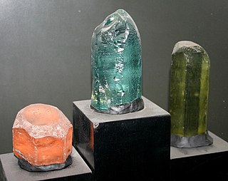
Beryl ( BERR-əl) is a mineral composed of beryllium aluminium silicate with the chemical formula Be3Al2Si6O18. Well-known varieties of beryl include emerald and aquamarine. Naturally occurring hexagonal crystals of beryl can be up to several meters in size, but terminated crystals are relatively rare. Pure beryl is colorless, but it is frequently tinted by impurities; possible colors are green, blue, yellow, pink, and red (the rarest). It is an ore source of beryllium.

The Humboldt–Toiyabe National Forest (HTNF) is the principal U.S. National Forest in the U.S. state of Nevada, and has a smaller portion in Eastern California. With an area of 6,289,821 acres (25,454.00 km2), it is the largest U.S. National Forest outside of Alaska.

Tiger's eye is a chatoyant gemstone that is usually a metamorphic rock with a golden to red-brown colour and a silky lustre. As members of the quartz group, tiger's eye and the related blue-coloured mineral hawk's eye gain their silky, lustrous appearance from the parallel intergrowth of quartz crystals and altered amphibole fibres that have mostly turned into limonite.

The St. Francois Mountains in southeast Missouri are a mountain range of Precambrian igneous mountains rising over the Ozark Plateau. This range is one of the oldest exposures of igneous rock in North America. The name of the range is spelled out as Saint Francois Mountains in official GNIS sources, but it is sometimes misspelled in use as St. Francis Mountains to match the anglicized pronunciation of both the range and St. Francois County.

The Blue Ridge Mountains are a physiographic province of the larger Appalachian Highlands range. The mountain range is located in the Eastern United States and extends 550 miles southwest from southern Pennsylvania through Maryland, West Virginia, Virginia, North Carolina, South Carolina, Tennessee, and Georgia. The province consists of northern and southern physiographic regions, which divide near the Roanoke River gap. To the west of the Blue Ridge, between it and the bulk of the Appalachians, lies the Great Appalachian Valley, bordered on the west by the Ridge and Valley province of the Appalachian range.

Ultisol, commonly known as red clay soil, is one of twelve soil orders in the United States Department of Agriculture soil taxonomy. The word "Ultisol" is derived from "ultimate", because Ultisols were seen as the ultimate product of continuous weathering of minerals in a humid, temperate climate without new soil formation via glaciation. They are defined as mineral soils which contain no calcareous material anywhere within the soil, have less than 10% weatherable minerals in the extreme top layer of soil, and have less than 35% base saturation throughout the soil. Ultisols occur in humid temperate or tropical regions. While the term is usually applied to the red clay soils of the Southern United States, Ultisols are also found in regions of Africa, Asia, and South America.

Ute Mountain, also known as Ute Peak or Sleeping Ute Mountain, is a peak within the Ute Mountains, a small mountain range in the southwestern corner of Colorado. It is on the northern edge of the Ute Mountain Ute Tribe Reservation. The Reservation forms the southwestern corner of the state and of Montezuma County.

The Innuitian Mountains are a mountain range in Nunavut and the Northwest Territories, Canada. They are part of the Arctic Cordillera and are largely unexplored, due to the hostile climate. They are named after the northern indigenous people, the Inuit. In some locations the Innuitian Mountains measure over 2,500 m (8,202 ft) in height, and 1,290 km (802 mi) in length. The highest point is Barbeau Peak on Ellesmere Island at 2,616 m (8,583 ft). There are no trees and minimal wildlife in the Innuitian Mountains due to the harsh cold climate as well as being located north of the Arctic tree line. This region is mostly barren with vast areas of permafrost. There are metallic mineral resources including iron and zinc and fossil fuel resources such as coal.

Mount Sherman is a high mountain summit in the Mosquito Range of the Rocky Mountains of North America. The 14,043-foot (4,280 m) fourteener is located 6.8 miles (11.0 km) east by south of the City of Leadville, Colorado, United States, on the drainage divide separating Lake County from Park County. The mountain was named in honor of General William Tecumseh Sherman.

The Spectrum Range, formerly called the Spectrum Mountains and the Rainbow Mountains, is a subrange of the Tahltan Highland in the Stikine Country of northwestern British Columbia, 20 km west of the Stewart-Cassiar Highway, south of Mount Edziza and north of the Arctic Lake Plateau. The Spectrum Range falls within Mount Edziza Provincial Park. The range is lightly glaciated, as compared to the other ranges to the west. It is accessible only by foot or via helicopter; there are no roads to the range.

The Mount Washington Wilderness is a wilderness area located on and around Mount Washington in the central Cascade Range of Oregon in the United States. The wilderness was established in 1964 and comprises 54,278 acres (219.66 km2) of the Willamette National Forest and Deschutes National Forest. It is administered by the U.S. Forest Service.

North Table Mountain is a mesa on the eastern flank of the Front Range of the Rocky Mountains of North America. The 6,555-foot (1,998 m) mesa summit is located in North Table Mountain Park, 3.4 miles (5.5 km) north by east of downtown Golden, Colorado, United States, in Jefferson County.
The United States House Natural Resources Subcommittee on Energy and Mineral Resources is one of the five subcommittees within the House Natural Resources Committee

The Palos Verdes Hills are a low mountain range on the southwestern coast of Los Angeles County, California. They sit atop the Palos Verdes Peninsula, a sub-region of the Los Angeles metropolitan area.

The Castle Dome Mountains are a mountain range in Yuma County, Arizona, within the Kofa National Wildlife Refuge. Castle Dome Peak, the high point of the range, is a prominent butte and distinctive landmark. The peak is 3,780 feet (1,152 m) high, and is located at 33°05′04″N 114°08′36″W. Castle Dome was named by American soldiers at old Fort Yuma in the 1880s. Early Spanish explorers called the same peak Cabeza de Gigante, "Giant's Head."

A geologist is a scientist who studies the solid, liquid, and gaseous matter that constitutes Earth and other terrestrial planets, as well as the processes that shape them. Geologists usually study geology, earth science, or geophysics, although backgrounds in physics, chemistry, biology, and other sciences are also useful. Field research is an important component of geology, although many subdisciplines incorporate laboratory and digitalized work. Geologists can be classified in a larger group of scientists, called geoscientists.

Treasure Mountain, elevation 13,535 ft (4,125 m), is a summit in the Elk Mountains of western Colorado. The mountain is in the Raggeds Wilderness southeast of Marble. The massif has been the site of marble mining and a legend of lost French gold.

West Elk Peak, elevation 13,042 ft (3,975 m), is the highest summit in the West Elk Mountains of Gunnison County, Colorado. The mountain is in the West Elk Wilderness, northwest of Gunnison. The terrain consists mostly of volcanic breccia, known in this area as West Elk Breccia, dated at 35 to 30 million years old.

The Mineral Park mine is a large open pit copper mine located in the Cerbat Mountains 14 miles northwest of Kingman, Arizona, in the southwestern United States. A 2013 report said that Mineral Park represented one of the largest copper reserves in the United States and in the world, having estimated reserves of 389 million tonnes of ore grading 0.14% copper and 31 million oz of silver.


