
A mountain pass is a navigable route through a mountain range or over a ridge. Since mountain ranges can present formidable barriers to travel, passes have played a key role in trade, war, and both human and animal migration throughout history. At lower elevations it may be called a hill pass. A mountain pass is typically formed between two volcanic peaks or created by erosion from water or wind.

Torreys Peak is a mountain in the Front Range region of the Rocky Mountains in Colorado. It is one of 53 fourteeners in Colorado. Its nearest major city is Denver. Torreys Peak is located along the Continental Divide, as well as the division between Clear Creek County and Summit County. In the Arapaho language Torrey's Peak and the adjacent Gray's Peak are named, Heeniiyoowuu or "Ant Hills".
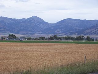
The Bridger Range, also known as the Bridger Mountains, is a subrange of the Rocky Mountains in southwestern Montana in the United States. The range runs mostly in a north–south direction between Bozeman and Maudlow. It is separated from the Gallatin Range to the south by Bozeman Pass; from the Horseshoe Hills to the west by Dry Creek; from the Crazy Mountains to the east by the Shields River valley; and from the Big Belt Mountains to the north by Sixteen Mile Creek. The highest point in the Bridger Range is Sacagawea Peak, which is visible to the northeast from Bozeman.

Grand Teton is the highest mountain of the Teton Range in Grand Teton National Park at 13,775 feet (4,199 m) in Northwest Wyoming. Below its north face is Teton Glacier. The mountain is a classic destination in American mountaineering via the Owen-Spalding route, the North Ridge and North Face.

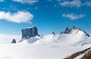
The Sentinel Range is a major mountain range situated northward of Minnesota Glacier and forming the northern half of the Ellsworth Mountains in Antarctica. The range trends NNW-SSE for about 185 km (115 mi) and is 24 to 48 km wide. Many peaks rise over 4,000 m (13,100 ft) and Vinson Massif (4892 m) in the southern part of the range is the highest elevation on the continent.
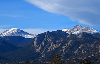
The Mummy Range is a mountain range in the Rocky Mountains of northern Colorado in the United States. The range is a short subrange of the Front Range located in southwestern Larimer County northwest of the town of Estes Park. It is located largely within Rocky Mountain National Park, extending north from Trail Ridge Road approximately 15 mi (24 km). The Arapaho name is "nooku-bee3ei-no," which translates to "White Owls."
For other uses, see Shadow Mountain (disambiguation)

Miller Peak, at 9,470 feet (2,886 m), is the second-highest mountain in Cochise County, Arizona. Located approximately 10 miles south of Sierra Vista, Arizona, it is the highest mountain in the Huachuca mountain range and a popular local hiking destination. The Miller Peak Wilderness encompasses 20,190 acres and is managed by the Coronado National Forest. This is also the most southerly peak and land area to rise above 9,000 feet in the continental United States. The area was affected by the 2011 Monument fire and most of the pine trees seen in older photographs were burned and destroyed. Scrub oak are beginning to replace the areas that were previously covered by pine.

East Spanish Peak is a prominent mountain summit that is the lower of the two Spanish Peaks in the Rocky Mountains of North America. The 12,688-foot (3,867 m) peak is located in the Spanish Peaks Wilderness of San Isabel National Forest, 9.3 miles (14.9 km) southeast by south of the Town of La Veta, Colorado, United States, on the drainage divide between Huerfano and Las Animas counties. The Spanish Peaks are two large igneous stocks which form an eastern outlier of the Culebra Range, a subrange of the Sangre de Cristo Mountains. East Spanish Peak is higher than any point in the United States east of its longitude; it is also the easternmost point in the United States over 12,000 feet (3,700 m), 11,000 feet (3,400 m), and 10,000 feet (3,000 m) feet above sea level.
The Sør Rondane Mountains are a group of mountains about 100 miles (160 km) long with main peaks rising to 3400 m, between the Queen Fabiola Mountains and Wohlthat Mountains in Queen Maud Land. They were discovered and photographed from the air by members of the Lars Christensen Expedition (LCE) on February 6, 1937, and named after Rondane, a mountain massif in southern Norway. The mountains and their constituent features were mapped in greater detail and named in 1957 by Norwegian cartographers working with air photos taken by U.S. Navy Operation Highjump, 1946–47.

Thompson Peak is the highest peak in the Sawtooth Range of Idaho. Its 10,751 ft (3,277 m) summit is located within Custer County, although some of the lower portion of the mountain is in Boise County. Thompson Peak is also located within the Sawtooth Wilderness portion of the Sawtooth National Recreation Area, a unit of Sawtooth National Forest. The town of Stanley, Idaho is about 6 miles (9.7 km) northeast of Thompson Peak.
The Dumont Hills are a low mountain range in the Mojave Desert, in northeastern San Bernardino County, southern California.

The Salt Spring Hills are a low mountain range in the Mojave Desert, in northern San Bernardino County, California. They are just outside the southeastern corner of Death Valley National Park, southeast of the Saddle Peak Hills. The road between Shoshone and Baker passes through the hills.
The Sperry Hills are a low mountain range in the northern Mojave Desert—southern Amargosa Desert region, in northeastern San Bernardino County, southern California.
The Valjean Hills are a low mountain range in the eastern Mojave Desert, in northern San Bernardino County, southern California.
The Mühlig-Hofmann Mountains is a major group of associated mountain features extending east to west for 100 km (62 mi) between the Gjelsvik Mountains and the Orvin Mountains in Queen Maud Land, East Antarctica. With its summit at 3,148 metres (10,328 ft), the massive Jøkulkyrkja Mountain forms the highest point in the Mühlig-Hofmann Mountains.

The saddle between two hills or mountains is the region surrounding the saddle point, the lowest point on the line tracing the drainage divide connecting the peaks. When, and if, the saddle is navigable, even if only on foot, the saddle of a (optimal) pass between the two massifs, is the area generally found around the lowest route on which one could pass between the two summits, which includes that point which is a mathematically when graphed a relative high along one axis, and a relative low in the perpendicular axis, simultaneously; that point being by definition the col of the saddle.

