
Butte County is a county located in the northern central part of the U.S. state of California. In the 2020 census, its population was 211,632. The county seat is Oroville.

Gridley is a city in Butte County, California, United States, 29 miles south of Chico, California, and 56 miles north of Sacramento, California. The population as of April 1, 2020, is 7,421. California State Route 99 runs through Gridley and Interstate 5 and California State Route 70 are both nearby.

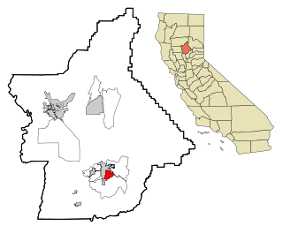
Oroville is the county seat of Butte County, California, United States. Its population was 15,506 at the 2010 census, up from 13,004 in the 2000 census. After the 2018 Camp Fire that destroyed much of the town of Paradise, Oroville's population increased as many people who lost their homes moved there. The 2020 census recorded Oroville's population as 20,042.
South Oroville is a census-designated place (CDP) in Butte County, California, United States. The population was 5,742 at the 2010 census, down from 7,695 at the 2000 census.

Oroville is a city located in the northern bulk of the Okanogan Highlands in north-central Washington, United States. Oroville is a member municipality of Okanogan County, Washington, situated between Omak and Penticton. The population was 1,795 at the 2020 census.

The Okanogan River is a tributary of the Columbia River, approximately 115 mi (185 km) long, in southern British Columbia and north central Washington. It drains a scenic plateau region called the Okanagan Country east of the Cascade Range and north and west of the Columbia, and also the Okanagan region of British Columbia. The Canadian portion of the river has been channelized since the mid-1950s.

The Feather River is the principal tributary of the Sacramento River, in the Sacramento Valley of Northern California. The river's main stem is about 73 miles (117 km) long. Its length to its most distant headwater tributary is just over 210 miles (340 km). The main stem Feather River begins in Lake Oroville, where its four long tributary forks join—the South Fork, Middle Fork, North Fork, and West Branch Feather Rivers. These and other tributaries drain part of the northern Sierra Nevada, and the extreme southern Cascades, as well as a small portion of the Sacramento Valley. The total drainage basin is about 6,200 square miles (16,000 km2), with approximately 3,604 square miles (9,330 km2) above Lake Oroville.

George Clement Perkins was an American businessman and politician. A member of the Republican Party, Perkins served as the 14th Governor of California from 1880 to 1883, and as United States Senator from California from 1893 to 1915. He also served in the California State Senate.

Oroville Dam is an earthfill embankment dam on the Feather River east of the city of Oroville, California, in the Sierra Nevada foothills east of the Sacramento Valley. At 770 feet (235 m) high, it is the tallest dam in the U.S. and serves mainly for water supply, hydroelectricity generation, and flood control. The dam impounds Lake Oroville, the second-largest reservoir in California, capable of storing more than 3.5 million acre-feet (1.1×10^12 US gal; 4.3×10⁹ m3).

Lake Oroville is a reservoir formed by the Oroville Dam impounding the Feather River, located in Butte County, northern California. The lake is situated 5 miles (8 km) northeast of the city of Oroville, within the Lake Oroville State Recreation Area, in the western foothills of the Sierra Nevada. Known as the second-largest reservoir in California, Lake Oroville is treated as a keystone facility within the California State Water Project by storing water, providing flood control, recreation, freshwater releases to assist in controlling the salinity intrusion into the Sacramento-San Joaquin Delta and protecting fish and wildlife.

State Route 149 is a short state highway in the U.S. state of California that helps to connect Oroville and Chico through rural Butte County. Connecting State Route 70 at Wicks Corner with State Route 99 east of Durham, it forms part of the primary north–south highway through the eastern Sacramento Valley, a Focus Route of the Interregional Road System.

The California State Water Project, commonly known as the SWP, is a state water management project in the U.S. state of California under the supervision of the California Department of Water Resources. The SWP is one of the largest public water and power utilities in the world, providing drinking water for more than 27 million people and generating an average of 6,500 GWh of hydroelectricity annually. However, as it is the largest single consumer of power in the state itself, it has a net usage of 5,100 GWh.

Oroville Municipal Airport is a public airport located 3 miles (5 km) southwest of the city of Oroville in Butte County, California, United States.

Molson is in Okanogan County, Washington, United States. By road, the community is 15.1 miles east of Oroville. The ghost town of Old Molson is 1.7 miles south of the Canada–United States border.

Lake Oroville State Recreation Area (LOSRA) is a state park unit of California, United States, surrounding Lake Oroville, a reservoir on the Feather River. It is located in Butte County outside Oroville, California. The 29,447-acre (11,917 ha) park was established in 1967. The recreation area "includes Lake Oroville and the surrounding lands and facilities within the project area as well as the land and waters in and around the Diversion Pool and Thermalito Forebay, downstream of Oroville Dam."

U.S. Route 97 in the U.S. state of Washington is a 322-mile (518 km) route which traverses from the Oregon state line at the northern end of the Sam Hill Memorial Bridge in Maryhill, north to the Canada–US border in Okanogan County near Oroville. The highway serves major cities such as Goldendale, Yakima, Ellensburg and Wenatchee before continuing towards the Alaska Highway at the Yukon border as British Columbia Highway 97. Along the length of the roadway, US 97 is concurrent with State Route 14 in Maryhill, Interstate 82 (I-82) and US 12 between Union Gap and Ellensburg, I-90 briefly in Ellensburg, US 2 between Peshastin and rural Douglas County and SR 20 near Omak. An alternate route connects the highway with Chelan.

The Oroville–Thermalito Complex is a group of reservoirs, structures, and facilities located in and around the city of Oroville in Butte County, California. The complex serves not only as a regional water conveyance and storage system, but is the headwaters for, and therefore perhaps is the most vital part of, the California Department of Water Resources' State Water Project, as one of the largest publicly built and operated water and power development and conveyance systems.
Oroville High School is a public high school located in the rural north valley at the base of the Sierra Nevada foothills, about seventy miles north of Sacramento, California, United States. Founded in 1892, Oroville High School is the oldest high school in the district. The campus covers 4 acres (16,000 m2). Of the 46 classrooms on campus, five have full functioning computer labs. The campus also has two computer labs and a library.
Osoyoos Lake State Park was a Washington state park in Okanogan County until it was sold to the city of Oroville and renamed Osoyoos Lake Veteran’s Memorial Park. The park has a 300-foot (91 m) sandy beach on Osoyoos Lake, boat ramp, and campground.
Sugarloaf is in the name of two different mountains that are located in Butte County of northern California.
