
Richmond is a city in western Contra Costa County, California, United States. The city was incorporated on August 7, 1905, and has a city council. Located in the San Francisco Bay Area's East Bay region, Richmond borders San Pablo, Albany, El Cerrito and Pinole in addition to the unincorporated communities of North Richmond, Hasford Heights, Kensington, El Sobrante, Bayview-Montalvin Manor, Tara Hills, and East Richmond Heights, and for a short distance San Francisco on Red Rock Island in the San Francisco Bay. Richmond is one of two cities, the other being San Rafael, that sits on the shores of both San Francisco Bay and San Pablo Bay.

Contra Costa County is located in the state of California in the United States. As of the 2010 census, the population was 1,049,025. The county seat is Martinez. It occupies the northern portion of the East Bay region of the San Francisco Bay Area, and is primarily suburban. The county's name is Spanish for "opposite coast", referring to its position on the other side of the bay from San Francisco. Contra Costa County is included in the San Francisco–Oakland–Berkeley, CA Metropolitan Statistical Area.

Tilden Regional Park, also known as Tilden Park or Tilden, is a 2,079-acre (841 ha) regional park in the East Bay, part of the San Francisco Bay Area in California. It is between the Berkeley Hills and San Pablo Ridge. Its main entrance is near Kensington, Berkeley, and Richmond. The park is contiguous with Wildcat Canyon Regional Park.

The Diablo Range is a mountain range in the California Coast Ranges subdivision of the Pacific Coast Ranges in northern California, United States. It stretches from the eastern San Francisco Bay area at its northern end to the Salinas Valley area at its southern end.

Black Mountain is a summit on Monte Bello Ridge in the Santa Cruz Mountains of west Santa Clara County, California, south of Los Altos and Los Altos Hills, and west of Cupertino; it is within the Palo Alto city limits though not near the developed part of the city. It is located on the border between Rancho San Antonio Open Space Preserve and Monte Bello Open Space Preserve, with the summit located in the former. Early Spanish explorers commonly named tree- or chaparral-covered summits which look black in the distance Loma Prieta, from the Spanish . The Spanish also called the middle portion of the Santa Cruz Mountains the Sierra Morena meaning, extending from Half Moon Bay Road south to a gap at Lexington Reservoir, and which includes a summit called Sierra Morena. There are over 100 "Black Mountains" in California.

The Berkeley Hills are a range of the Pacific Coast Ranges that overlook the northeast side of the valley that encompasses San Francisco Bay. They were previously called the "Contra Costa Range/Hills", but with the establishment of Berkeley and the University of California, the current usage was applied by geographers and gazetteers.

The Marin Hills are a series of steep high ridges and peaks in southern Marin County. They are a part of the long Pacific Coast Ranges mountain system. The centerpoint of these hills is the 2,571 foot Mount Tamalpais near Mill Valley. The hills are bordered to the north by the Santa Rosa Plain and Laguna de Santa Rosa; to the east by San Pablo Bay, the northern arm of San Francisco Bay; to the south by Golden Gate Strait; and to the west by the San Andreas Fault, running through Tomales Bay, Olema Valley, Bolinas Lagoon, and Stinson Beach. Parts of the hills are protected for their scenic beauty by Mount Tamalpais State Park and the Golden Gate National Recreation Area. The many ridges and peaks of these hills form a dramatic backdrop to the Golden Gate Bridge, the San Francisco skyline, and several towns around Richardson Bay when viewed from the south.
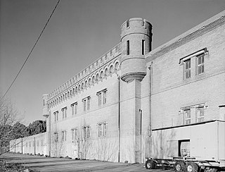
Winehaven was a winery and town in Richmond, California, that held the title of "world's largest winery" for 12 years (1907–1919). It later became a fuel depot for the United States Navy.

Wildcat Canyon Regional Park is a 2,429-acre (983 ha) East Bay Regional Parks District park located within the city limits of Richmond in Contra Costa County in the San Francisco Bay Area of California. It includes a portion of Wildcat Canyon as well as a portion of the adjoining San Pablo Ridge, and is directly connected to the more heavily used Tilden Regional Park.
The Richmond Greenway is a pedestrian and bicycle path in Richmond, California.

Point San Pablo Harbor is a marina and small community at the far end of Point San Pablo in San Pablo Bay, within Richmond, in Contra Costa County, California. It is located at 1900 Stenmark Drive, Richmond CA 94801.
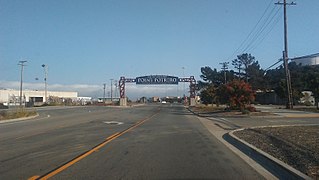
Point Potrero is a point in San Pablo Bay forming a cape and hugging the Potrero Hills in Richmond, California.
San Pablo Peninsula is a peninsula in western Richmond, between San Pablo Bay and San Rafael Bay, in southwestern Contra Costa County, California.

Point Molate Naval Fuel Depot is a decommissioned United States Navy fueling station on the western shore of Richmond, California on San Francisco Bay. It has undergone years of litigation and debate as to its redevelopment with proposals ranging from a billion dollar casino project, parkland, housing, and other mixed uses.
Point Molate may refer to:

Potrero Hills Pond is a small lake in Richmond, California. It was formed from quarrying of hills near Potrero Hills at the Blake Brothers Quarry. It is fed by underground springs. It is now polluted and surrounded by a Chevron Richmond Refinery tank farm.
The Richmond–San Rafael Ferry Company began as the Richmond–San Rafael Ferry and Transportation Company, and is a defunct ferry service that provided a water transport link between Castro Point in Richmond, California in Contra Costa County and San Quentin in Marin County across the San Pablo Bay before the construction of the Richmond–San Rafael Bridge.
The San Pablo Fault is a fault in northern California. It is an offshoot of the Hayward Fault. It formed the Potrero Hills in Richmond, California.
Red Rock Cove is an embayment on San Pablo Bay in Richmond, California. It is a cove named after Red Rock Island and lays along Point Molate Beach Park.
Castro Point is a cape in western Richmond, California, United States.
