Carriage Hills, a residential subdivision and the neighborhood is an incorporated integral part of Richmond in the U.S. state of California.
Carriage Hills, a residential subdivision and the neighborhood is an incorporated integral part of Richmond in the U.S. state of California.
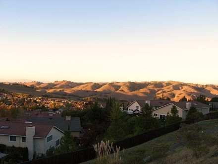
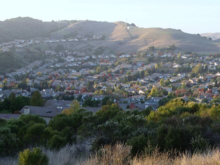
It is located in an incorporated part of Richmond. However, due to the zip code, most residents claim residency in El Sobrante. This area is serviced by the El Sobrante post office (zip code 94803), while police and waste management services are provided by the city of Richmond. It is a middle class area and features moderately packed tract homes with medium-sized yards.
The Carriage Hills area is on the margin of urban development spawl with a large expanse of undeveloped land, parks and open space immediately surrounding the area, including the Sobrante Ridge Preserve. People may enjoy hiking and wildlife year-round, as well as rolling views of green or yellow grasses on bumpy hills depending on what time of year it is.
Castro Ranch Road separates Carriage Hills North and Carriage Hills South. The road runs into Pinole Valley Road to the east and San Pablo Dam Road to the west, both of which lead to Interstate 80.
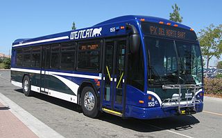
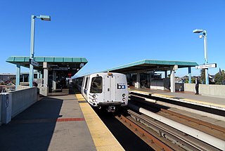
The neighborhood was formerly served by County Connection bus service, route 950 from Carriage Hills to Orinda BART Station, but this service was eliminated. It was replaced by AC Transit's route 74 23rd Street [1] line, although this line does not directly service Carriage Hills, and requires a 1-mile (1.6 km) walk, it runs from the stop at Castro Ranch Road to the Richmond BART and Amtrak Station. Prior to October 2010, it also ran to the Orinda BART Station, but budget cuts eliminated this vital connection. The only remaining transit service is AC Transit school route 669 that connects those headed to DeAnza High School and Juan Crespí Middle School from the neighborhood once in the morning and twice in the afternoon, during the school year, in both directions. [2]

Richmond is a city in western Contra Costa County, California, United States. The city was incorporated on August 7, 1905 and has a city council. Located in the East Bay region of the San Francisco Bay Area, Richmond borders the cities of San Pablo, Albany, El Cerrito and Pinole in addition to the unincorporated communities of North Richmond, Hasford Heights, Kensington, El Sobrante, Bayview-Montalvin Manor, Tara Hills, and East Richmond Heights, and for a short distance San Francisco on Red Rock Island in the San Francisco Bay. Richmond is one of two cities, the other being San Rafael, California, that sits on the shores of San Francisco Bay and San Pablo Bay simultaneously.

Contra Costa County is a county in the state of California in the United States. As of the 2010 census, the population was 1,049,025. The county seat is Martinez. It occupies the northern portion of the East Bay region of the San Francisco Bay Area, and is primarily suburban. The county's name is Spanish for "opposite coast", referring to its position on the other side of the bay from San Francisco. Contra Costa County is included in the San Francisco–Oakland–Berkeley, CA Metropolitan Statistical Area.

El Sobrante is a census-designated place (CDP) in Contra Costa County, California, United States. The population was 12,669 at the 2010 census.

San Pablo is a city in Contra Costa County, California, United States. The city of Richmond surrounds nearly the whole city. The population was 29,139 at the 2010 census. The current Mayor is Arturo Cruz. Currently, the City Council consists of Rich Kinney, Elizabeth Pabon-Alvarado, Rita Xavier and Abel Pineda.

AC Transit is an Oakland-based public transit agency serving the western portions of Alameda and Contra Costa counties in the East Bay of the San Francisco Bay Area. AC Transit also operates "Transbay" routes across San Francisco Bay to San Francisco and selected areas in San Mateo and Santa Clara counties. AC Transit is constituted as a special district under California law. It is governed by seven elected members. It is not a part of or under the control of Alameda or Contra Costa counties or any local jurisdictions.
WestCAT is a public transportation service in western Contra Costa County. It is a service of the Western Contra Costa Transit Authority.

WHEELS is a bus service that provides public transportation in the Tri-Valley Region of the San Francisco Bay Area, in the United States. Started in 1986, Wheels offers service to various communities in three cities, and connects to Bay Area Rapid Transit (BART) and Altamont Corridor Express (ACE) trains for connections to and from the greater Bay Area and Central Valley.
West Oakland is a Bay Area Rapid Transit (BART) station serving the West Oakland neighborhood in Oakland, California, United States. It has two elevated side platforms, and is located near the eastern end of the Transbay Tube. All lines except the Richmond-Warm Springs/South Fremont line stop at the station.
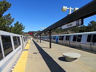
Orinda is a Bay Area Rapid Transit station in Orinda, California. The station has an island platform in the center median of State Route 24. Service at the station began on May 21, 1973, following the completion of the Berkeley Hills Tunnel, which connects it to Rockridge station. An abstract mural by Win Ng, partially covered by advertisements, is located in the fare lobby.
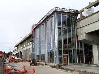
El Cerrito del Norte is a BART station located off Cutting Boulevard near San Pablo Avenue and Interstate 80 in El Cerrito, California. The station serves as a regional transit hub for local AC Transit bus services, and for commuter feeder services from Solano, Napa, and Marin Counties in the North Bay plus western Contra Costa County. Opened in 1973, the station is undergoing a renovation expected to be completed in 2019.

The Richmond Parkway Transit Center or RPTC is a park and ride lot and bus terminal located in Richmond, California. It is named after the adjacent Richmond Parkway. It serves as a transfer point for the WestCAT and AC Transit. It is located on the corner of Richmond Parkway and Blume Drive near the Pinole border and adjacent to Interstate 80 and the Hilltop Plaza shopping center.
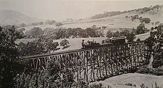
The California and Nevada Railroad was a 3 ft narrow gauge steam railroad which ran in the East Bay of the San Francisco Bay Area in the late 19th century. It was incorporated on March 25, 1884. J.S. Emery was listed as the railroad's president, for which present day Emeryville is named. On March 1, 1885 the track was completed between Oakland and San Pablo via Emeryville. The track to Oak Grove was completed on January 1, 1887.

The All Nighter is a night bus service network in the San Francisco Bay Area, California. Portions of the service shadow the rapid transit and commuter rail services of BART and Caltrain, which are the major rail services between San Francisco, the East Bay, the Peninsula, and San Jose. Both BART and Caltrain do not operate owl service so that track maintenance can be performed and the All Nighter network helps fill in this service gap. The slogan is, "Now transit stays up as late as you do!"

Fairmede-Hilltop, more commonly known simply as Hilltop, is a neighborhood located in the northeastern area of Richmond, California.

Richmond Heights formerly East Richmond and also known as Mira Vista is a district of eastern Richmond, California in the San Francisco Bay Area.

Downtown Oakland is the central business district of Oakland, California, United States; roughly bounded by both the Oakland Estuary and Interstate 880 on the southwest, Interstate 980 on the northwest, Grand Avenue on the northeast, and Lake Merritt on the east.

San Pablo Creek is an 18.7-mile-long (30.1 km) creek in Contra Costa County, California, United States, which drains the canyon or valley between the San Pablo Ridge and the Sobrante Ridge, parts of the Pacific Coast Ranges east of San Francisco Bay.
Hilltop Green or "The Green"is a neighborhood in Richmond, California bordering the city of Pinole, the census-designated place of El Sobrante, the neighborhood of Hilltop, and Hilltop Mall.
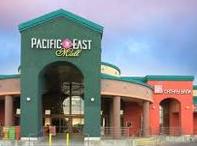
Pacific East Mall is an Asian mall in Richmond, California. It is owned by Pacific Infinity Company Incorporated.
Olde Richmond is a neighborhood in the River Wards section of Philadelphia, Pennsylvania. It is notable for its historically large Polish immigrant, Polish American community, and Irish American community. The U.S. zip code for Olde Richmond is 19125 and its Post Office is located at 1602 Frankford Avenue.
| This Contra Costa County, California–related article is a stub. You can help Wikipedia by expanding it. |