
Millbrae station is an intermodal transit station serving Bay Area Rapid Transit (BART) and Caltrain, located in Millbrae, California. The station is the terminal station for BART on the San Francisco Peninsula, served by two lines: The Red Line before 9 pm and the Yellow Line during the early morning and evening. It is served by all Caltrain services. The station is also served by SamTrans bus service, Commute.org and Caltrain shuttle buses, and other shuttles.
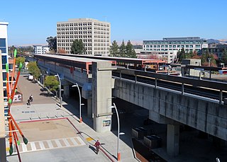
Walnut Creek station is an elevated Bay Area Rapid Transit (BART) station in Walnut Creek, California, served by the Yellow Line. The station is located north of downtown Walnut Creek, adjacent to Interstate 680 and near the Ygnacio Valley Road and California Boulevard arterial roads.

Richmond station is an Amtrak intercity rail and Bay Area Rapid Transit (BART) station located in downtown Richmond, California. Richmond is the north terminus of BART service on the Orange Line and Red Line; it is a stop for Amtrak's Capitol Corridor, San Joaquins, and California Zephyr routes. The accessible station has one island platform for the two BART tracks, with a second island platform serving two of the three tracks of the Union Pacific Railroad Martinez Subdivision for Amtrak trains. It is one of two transfer points between BART and Amtrak, along with Oakland Coliseum station.

Ashby station is an underground Bay Area Rapid Transit (BART) station in Berkeley, California. The station is located beneath Adeline Street to the south of its intersection with Ashby Avenue. The station includes park-and-ride facilities with 715 automobile parking spaces in two separate parking lots. It is served by the Orange and Red lines.

MacArthur station is a Bay Area Rapid Transit (BART) station in the Temescal District of Oakland, California. It is the largest station in the BART system, being the only one with four platform tracks. Service through MacArthur is timed for cross-platform transfers between the southbound lines that pass through the station. MacArthur station is located in the median of SR 24 just north of its interchange with I-580. The station is perpendicular to 40th Street and MacArthur Boulevard. The surrounding neighborhood is mostly low-density residential, making MacArthur station primarily a commuting hub.
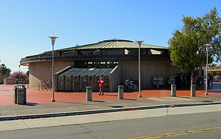
North Berkeley station is an underground Bay Area Rapid Transit (BART) station located in the North Berkeley neighborhood of Berkeley, California. It is bounded by Virginia Street, Sacramento Street, Delaware Street, and Acton Street in a residential area north of University Avenue. The main station entrance sits within a circular building at the center of a parking lot, while an elevator between the surface and the platform is located at the parking lot's Sacramento Street edge. The station is served by the Orange and Red lines.
Point Richmond, also sometimes referred to locally as The Point, is a neighborhood in Richmond, California, United States, near the eastern end of the Richmond-San Rafael Bridge, between Interstate 580 and the San Francisco Bay.

The Richmond Parkway Transit Center, or RPTC, is a park and ride lot and bus terminal located in Richmond, California. It is named after the adjacent Richmond Parkway and serves as a transfer point for WestCAT and AC Transit. The center is situated on the corner of Richmond Parkway and Blume Drive, near the Pinole border and adjacent to Interstate 80 and the Hilltop Plaza shopping center.
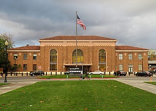
San Jose Diridon station is the central passenger rail depot for San Jose, California. It also serves as a major intermodal transit center for Santa Clara County and Silicon Valley. The station is named after former Santa Clara County Supervisor Rod Diridon Sr.
Oakland City Center is an office, shopping and hotel complex in Downtown Oakland, Oakland, California. The complex is the product of a redevelopment project begun in the late 1950s. It covers twelve city blocks between Broadway on the east, Martin Luther King Jr. Way on the west, Frank H. Ogawa Plaza on 14th Street on the north side of the complex and the Oakland Convention Center and Marriott Hotel extend south to 10th Street. An hourly parking garage is located beneath the complex's shopping mall. The mall features an upscale fitness and racquet club, in addition to numerous take-out restaurants and other stores. The complex is served by the 12th Street/Oakland City Center BART station.

Downtown Berkeley is the central business district of the city of Berkeley, California, United States, around the intersection of Shattuck Avenue and Center Street, and extending north to Hearst Avenue, south to Dwight Way, west to Martin Luther King Jr. Way, and east to Oxford Street. Downtown is the mass transit hub of Berkeley, with several AC Transit and UC Berkeley bus lines converging on the city's busiest BART station, as well as the location of Berkeley's civic center, high school, and Berkeley City College.

The station complex of Amtrak's Oakland Coliseum station and Bay Area Rapid Transit (BART)'s Coliseum station is located in the East Oakland area of Oakland, California, United States. The two stations, located about 600 feet (180 m) apart, are connected to each other and to the Oakland Coliseum/Oakland Arena sports complex with an accessible pedestrian bridge. The BART station is served by the Orange, Green, and Blue lines; the Amtrak station is served by the Capitol Corridor service.
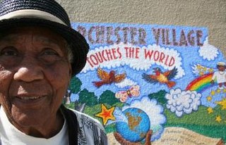
Parchester Village is a planned majority African-American village in northwestern Richmond, California that was the first in the state to sell to blacks.
Campus Bay is an 87-acre (350,000 m2) property in the city of Richmond, California located off Interstate 580 (California), and situated between the San Francisco Bay, the Richmond Annex, and Point Isabel neighborhoods. The area receives its name from its proximity to the UC Berkeley Richmond Field Station.

Bear Transit is the bus service operated by the Department of Parking and Transportation of the University of California, Berkeley. Its fleet includes a combination of shuttle vans and passenger buses, provided by MV Transit.

Downtown Oakland is the central business district of Oakland, California, United States. It is located roughly bounded by both the Oakland Estuary and Interstate 880 on the southwest, Interstate 980 on the northwest, Grand Avenue on the northeast, and Lake Merritt on the east.

Hercules Transit Center is a major commuter hub in the western Contra Costa County city of Hercules, California. It is anchored by WestCAT bus services. The center was originally on San Pablo Avenue. In August 2009, the transit center was relocated to the other side of I-80 with additional paid parking, which is $3/day.

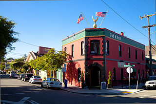
The Point Richmond Historic District is the downtown area of Point Richmond in Richmond, California. It has been listed as a historic district on the National Register of Historic Places since November 5, 1979, for architecture and historical significance.

Hercules station is a proposed intermodal infill train station and ferry terminal in Hercules, California in Contra Costa County. It is to be the first direct Amtrak-to-ferry transit hub in the San Francisco Bay Area and will be constructed in between the existing Richmond and Martinez stations. By July 2018, three of the station's six construction phases had been complete, including street at Bay Trail approaches. However, no proposed opening date has yet been announced by the City of Hercules.
Abella Center formerly International Marketplace and originally El Portal Shopping Center is a mixed-use city services, business, shopping center and housing village transit-oriented development that was formerly a mall in San Pablo, California.


