Panhandle is the county seat of Carson County, Texas, United States. The population of the town was 2,452 at the 2010 census. Panhandle is part of the Amarillo metropolitan statistical area.
The Columbus Panhandles were a professional American football team based in Columbus, Ohio. The club was founded in 1901 by workers at the Panhandle shops of the Pennsylvania Railroads. They were a part of the Ohio League from 1904 before folding after one season. Three years later, the team tried again and playing the Ohio League from 1907 to 1919, not winning a championship, before becoming charter members of the American Professional Football Association (APFA) which became the National Football League (NFL).

The Texas Panhandle is a region of the U.S. state of Texas consisting of the northernmost 26 counties in the state. The panhandle is a rectangular area bordered by New Mexico to the west and Oklahoma to the north and east. The Handbook of Texas defines the southern border of Swisher County as the southern boundary of the Texas Panhandle region.

The Northern Panhandle is the northern of the two panhandles in the U.S. state of West Virginia. It is a culturally and geographically distinct region of the state. It is the state's northernmost extension, bounded by Ohio and the Ohio River on the north and west and the state of Pennsylvania on the east. Its unusual configuration is the result of the Revolutionary-era claims of Virginia's former Yohogania County boundary lying along the Ohio River, conflicting with interpretations of the Colony of Pennsylvania's royal charter. The conflict was settled by compromise in the 1780s. Today, due to the southern boundary being an extension of the Mason–Dixon line and the panhandle's proximity to the Pittsburgh area, the Northern Panhandle resembles more of the Midwestern United States or the Northeastern United States compared to the rest of the state, which is classified as part of the Upland South.

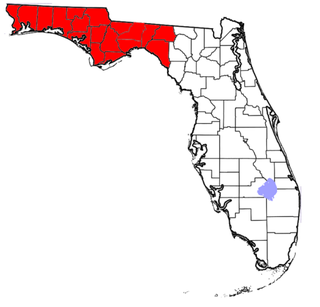
The Florida Panhandle, an informal, unofficial term for the northwestern part of the U.S. state of Florida, is a strip of land roughly 200 miles (320 km) long and 50 to 100 miles wide, lying between Alabama on the north and the west, Georgia on the north, and the Gulf of Mexico to the south. Its eastern boundary is arbitrarily defined. The terms West Florida and Northwest Florida are today generally synonymous with the Panhandle, although historically West Florida was the name of a British colony (1763–1783), later a Spanish colony (1783–1821), both of which included modern-day Florida west of the Apalachicola River as well as portions of what are now Alabama, Mississippi, and Louisiana.

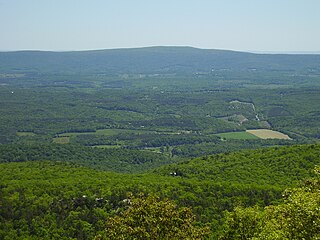
The Eastern Panhandle is the eastern of the two panhandles in the U.S. state of West Virginia. It is a small stretch of territory in the northeast of the state, bordering Maryland and Virginia. Some sources and regional associations only identify the Eastern Panhandle as being composed of Morgan, Berkeley, and Jefferson Counties. Berkeley and Jefferson Counties are geographically located in the Shenandoah Valley. West Virginia is unusual in having two panhandles, the Eastern Panhandle and the Northern Panhandle.

The Nebraska Panhandle is an area in the western part of the state of Nebraska and one of several U.S. state panhandles, or elongated geographical regions that extend from their main political entity.

The Idaho Panhandle—locally known as North Idaho—is a region in the U.S. state of Idaho encompassing the state's 10 northernmost counties: Benewah, Bonner, Boundary, Clearwater, Idaho, Kootenai, Latah, Lewis, Nez Perce, and Shoshone. The Panhandle is bordered by the state of Washington to the west, Montana to the east, and the Canadian province of British Columbia to the north. The Idaho panhandle, along with Eastern Washington, comprises the region known as the Inland Northwest. Coeur d'Alene is the largest city within the Idaho Panhandle. Spokane, Washington is around 30 miles (48 km) west of Coeur d'Alene, and is also the location of the regional airport, Spokane International Airport. Other important cities in the region include Lewiston, Moscow, Post Falls, Hayden, Sandpoint, and the smaller towns of St. Maries and Bonners Ferry. East of Coeur d'Alene is the Silver Valley, which follows Interstate 90 to the Montana border at Lookout Pass.

The Panhandle is a park in San Francisco, California, that forms a panhandle with Golden Gate Park. It is long and narrow, being three-quarters of a mile long and one block wide. Fell Street borders it to the north, Oak Street to the south, and Baker Street to the east. Only two streets run through it - Stanyan Street at the western end between it and Golden Gate Park and Masonic Avenue through the middle. Two paved walking paths run through it from Golden Gate Park to Baker Street, one allowing bicycles. There are basketball courts, a public restroom, and a playground in the section between Stanyan Street and Masonic Avenue.

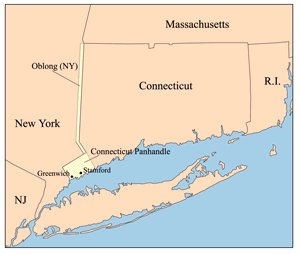
The Connecticut Panhandle is the southwestern appendage of Connecticut, where it abuts New York State. It is contained entirely in Fairfield County and includes all of Greenwich, Stamford, New Canaan, and Darien, as well as parts of Norwalk and Wilton. It has some of the most expensive residential real estate in the United States.

The Idaho Panhandle National Forests are a jointly administered set of three national forests located in the U.S. state of Idaho. Approximately 22.4% of the forest extends into the states of Montana (14.1%) and Washington (8.3%). The IPNF were created in 2000 to administer three separate national forests that continue to manage themselves somewhat separately through district offices. The Coeur d'Alene, St. Joe, and Kaniksu National Forests together occupy 3,224,739-acre in northern Idaho. The northernmost portion of the IPNF share a boundary with Canada. Its headquarters are located in Coeur d'Alene, Idaho.

The Wildcat Hills are an escarpment between the North Platte River and Pumpkin Creek in the western Panhandle, in the state of Nebraska in the Great Plains region of the United States. Located in Banner, Morrill, and Scotts Bluff counties, the high tableland between the streams has been eroded by wind and water into a region of forested buttes, ridges and canyons that rise 150 to 300 m above the surrounding landscape.

Sleepy Creek Mountain is a mountain ridge in the Ridge-and-Valley Appalachians on the border between Morgan and Berkeley counties in the Eastern Panhandle of West Virginia. The long-distance Tuscarora Trail traverses the southern ridge and northern bench of the mountain.

Third Hill Mountain is both the highest and most topographically prominent mountain in Berkeley County within the Eastern Panhandle of West Virginia. Third Hill Mountain reaches its highest elevation of 2,165 feet (660 m) above sea-level southeast of the "Locks-of-the-Mountain" where it "locks" with Sleepy Creek Mountain. The long distance Tuscarora Trail passes along ridge and bench of the mountain.
The Panhandle Trail is a rail trail in southern Pennsylvania and the Northern Panhandle of West Virginia. It occupies an abandoned railroad corridor that had been known as the Panhandle route which has been converted to a bicycle and walking trail. The rail line covers a distance of 29 miles (47 km) and was abandoned in 1992. The original section of the trail is the West Virginia section, where the trail was called the Harmon Creek Trail, for the adjacent Harmon Creek. When Pennsylvania built its section, both states agreed to call it the Panhandle Trail. Although the Panhandle Trail occupies 29 miles of the Panhandle Route, the remaining portion of the route is owned by the Pittsburgh and Ohio Central Railroad, but it is no longer used.

The Amarillo Metropolitan Statistical Area is a metropolitan area in the Texas Panhandle that covers five counties: Armstrong, Carson, Potter, Randall, and Oldham. As of the 2010 census, the MSA had a population of 249,881.

Panhandle culture is a prehistoric culture of the southern High Plains during the Middle Ceramic Period from AD 1200 to 1400. Panhandle sites are primarily in the panhandle and west central Oklahoma and the northern half of the Texas Panhandle.

Carrabelle River is located in Carrabelle, Florida, and flows into St. George Sound in Apalachicola Bay and the Gulf of Mexico. The area has been a base for commercial fishermen. It is home to a river festival. It is crossed by the Carrabelle River Bridge on U.S. Route 98. Upstream, the Carrabelle forks into the New River and Crooked River.
Homelessness in the United States exists in every state. Each state has different laws and other conditions which influence the number of homeless persons and what services are available to their homeless people.


