
The Jacumba Mountains are a mountain range of the Peninsular Ranges system, located in eastern San Diego County, Southern California, near the U.S. border with Mexico.

The Vallecito Mountains are located in the Colorado Desert, in eastern San Diego County, Southern California. They are about 28 miles (45 km) north of the U.S. border with Mexico.

When the Spanish arrived, they divided Peru into three main regions: the coastal region, that is bounded by the Pacific Ocean; the highlands, that is located on the Andean Heights, and the jungle, that is located on the Amazonian Jungle. But Javier Pulgar Vidal (es), a geographer who studied the biogeographic reality of the Peruvian territory for a long time, proposed the creation of eight Natural Regions. In 1941, he presented his thesis "Las Ocho Regiones Naturales del Perú" at the III General Assembly of the Pan-American Institute of Geography and History.
Tierra Blanca is a city and its surrounding municipality of the same name located in the south-central part of the state of Veracruz in Mexico. At the 2005 census the city had a population of 44,171 inhabitants, and 47,824 in 2015. The city serves as the municipal seat of the municipality, which has an area of 1,363.76 km² and a population of 86,075 inhabitants (2005) and 106,277 (2015). Its largest other community is the town of Joachín.

Tierra Blanca is a district of the Cartago canton, in the Cartago province of Costa Rica.
Tierra Blanca is a Mexican city located in the Northeast region of the state of Guanajuato. The municipality has an area of 391.65 square kilometres and is bordered to the north by Santa Catarina, to the south and the east to the state of Querétaro, to the west by San José Iturbide and to the northwest by Doctor Mora. The municipality had a population of 14,515 inhabitants according to the 2005 census. In pre-Hispanic times the area of what is today Tierra Blanca was mostly inhabited by Chichimeca people.

Ribera del Guadiana is a Spanish Denominación de Origen Protegida (DOP) for wines located in the region of Extremadura (Spain). It extends over two provinces, Cáceres in the north and Badajoz in the south. It takes its name from the River Guadiana, which flows through the region from east to west.
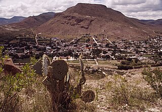
The town of Tierra Blanca is located in the municipality of Loreto in the Mexican state of Zacatecas. It has 2137 inhabitants. Tierra Blanca is 2077 meters above sea level. It is also the birthplace of Benjamín "El Maestro" Galindo. Tierra Blanca is also the birthplace of Omar Ortiz, lead singer of Pequeños Musical. Tierra Blanca is a very quiet and rural town. People often emigrate to the United States, to cities such as Los Angeles, Chicago, and Denver. There is also a "Garden", which is also referred to as "El Jardin." This is the setting where concerts, firework shows, etc., take place.

The Sawtooth Mountains are a mountain range of the Peninsular Ranges system, located in eastern San Diego County, California.
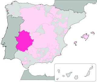
Extremadura is a Spanish geographical indication for Vino de la Tierra wines located in the autonomous region of Extremadura. Vino de la Tierra is one step below the mainstream Denominación de Origen indication on the Spanish wine quality ladder.
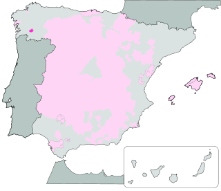
Val do Miño-Ourense is a Spanish geographical indication for Vino de la Tierra wines located in the autonomous region of Galicia. Vino de la Tierra is one step below the mainstream Denominación de Origen indication on the Spanish wine quality ladder.

Bajo Aragón is a Spanish geographical indication for Vino de la Tierra wines located in and near Lower Aragon, in the autonomous region of Aragon. Vino de la Tierra is one step below the mainstream Denominación de Origen indication on the Spanish wine quality ladder.
Ribera del Gállego-Cinco Villas is a Spanish geographical indication for Vino de la Tierra wines located in the wine-producing areas of Ribera del Gállego and the Cinco Villas, in the provinces of Huesca and Zaragoza, in the autonomous region of Aragon, Spain. Vino de la Tierra is one step below the mainstream Denominación de Origen indication on the Spanish wine quality ladder.

Ribera del Jiloca is a Spanish geographical indication for Vino de la Tierra wines located in the wine-producing area of the Jiloca Valley, in the provinces of Teruel and Zaragoza, in the autonomous region of Aragon, Spain. Vino de la Tierra is one step below the mainstream Denominación de Origen indication on the Spanish wine quality ladder.

Valdejalón is a Spanish geographical indication for Vino de la Tierra wines located in the wine-producing area of Valdejalón, in the province of Zaragoza, in the autonomous region of Aragon, Spain. Vino de la Tierra is one step below the mainstream Denominación de Origen indication on the Spanish wine quality ladder.

Valle del Cinca is a Spanish geographical indication for Vino de la Tierra wines located in the wine-producing area of the Cinca Valley, in the province of Huesca, in the autonomous region of Aragon, Spain. Vino de la Tierra is one step below the mainstream Denominación de Origen indication on the Spanish wine quality ladder.

Tezonapa is a municipality located in the high mountains region in the State of Veracruz, Mexico, about 219 km from state capital Xalapa. It covers an area of 351 square kilometres (136 sq mi). The law number 93 of December 22, 1960 San Agustín created Tezonapa's municipality with the congregations of the Josefinas, Prison, Tezonapa, Palmarito, etc.
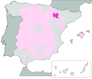
3 Riberas is a Spanish geographical indication for Vino de la Tierra wines located in the autonomous region of Navarre. Vino de la Tierra is one step below the mainstream Denominación de Origen indication on the Spanish wine quality ladder, and mirrors the Vins de pays of French wine. It acquired its Vino de la Tierra status in 2018.
IGP Murcia is a Spanish geographical indication for Vino de la Tierra wines located in the autonomous region of Murcia. Vino de la Tierra is one step below the mainstream Denominación de Origen indication on the Spanish wine quality ladder, and mirrors the Vins de pays of French wine. It acquired its Vino de la Tierra status in 2011.
National Tertiary Route 401, or just Route 401 is a National Road Route of Costa Rica, located in the Cartago province.
