
Southern California is a geographic and cultural region that generally comprises the southern portion of the U.S. state of California. It includes the Los Angeles metropolitan area as well as the Inland Empire. The region generally contains ten of California's 58 counties: Imperial, Kern, Los Angeles, Orange, Riverside, San Bernardino, San Diego, Santa Barbara, San Luis Obispo, and Ventura counties.

Inyo County is a county in the eastern central part of the U.S. state of California, located between the Sierra Nevada and the state of Nevada. In the 2020 census, the population was 19,016. The county seat is Independence. Inyo County is on the east side of the Sierra Nevada and southeast of Yosemite National Park in Central California. It contains the Owens River Valley; it is flanked to the west by the Sierra Nevada and to the east by the White Mountains and the Inyo Mountains. With an area of 10,192 square miles (26,400 km2), Inyo is the second-largest county by area in California, after San Bernardino County. Almost one-half of that area is within Death Valley National Park. However, with a population density of 1.8 people per square mile, it also has the second-lowest population density in California, after Alpine County.

The Humboldt–Toiyabe National Forest (HTNF) is the principal U.S. National Forest in the U.S. state of Nevada, and has a smaller portion in Eastern California. With an area of 6,289,821 acres (25,454.00 km2), it is the largest U.S. National Forest outside of Alaska.

Owens Valley is an arid valley of the Owens River in eastern California in the United States. It is located to the east of the Sierra Nevada, west of the White Mountains and Inyo Mountains, and is split between the Great Basin Desert and the Mojave Desert. The mountain peaks on the West side reach above 14,000 feet (4,300 m) in elevation, while the floor of the Owens Valley is about 4,000 feet (1,200 m), making the valley the deepest in the United States. The Sierra Nevada casts the valley in a rain shadow, which makes Owens Valley "the Land of Little Rain". The bed of Owens Lake, now a predominantly dry endorheic alkali flat, sits on the southern end of the valley.

The Mono–Inyo Craters are a volcanic chain of craters, domes and lava flows in Mono County, Eastern California. The chain stretches 25 miles (40 km) from the northwest shore of Mono Lake to the south of Mammoth Mountain. The Mono Lake Volcanic Field forms the northernmost part of the chain and consists of two volcanic islands in the lake and one cinder cone volcano on its northwest shore. Most of the Mono Craters, which make up the bulk of the northern part of the Mono–Inyo chain, are phreatic volcanoes that have since been either plugged or over-topped by rhyolite domes and lava flows. The Inyo volcanic chain form much of the southern part of the chain and consist of phreatic explosion pits, and rhyolitic lava flows and domes. The southernmost part of the chain consists of fumaroles and explosion pits on Mammoth Mountain and a set of cinder cones south of the mountain; the latter are called the Red Cones.

The Santa Rosa Mountains are a short mountain range in the Peninsular Ranges system, located east of the Los Angeles Basin and northeast of the San Diego metropolitan area of southern California, in the southwestern United States.

The Inyo Mountains are a short mountain range east of the Sierra Nevada in eastern California in the United States. The range separates the Owens Valley to the west from Saline Valley to the east, extending for approximately 70 miles (110 km) south-southeast from the southern end of the White Mountains, from which they are separated by Westgard Pass, to the east of Owens Lake.

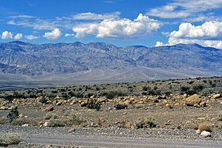
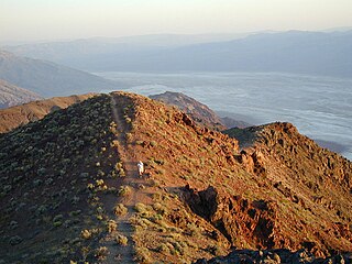
The Panamint Range is a short rugged fault-block mountain range in the northern Mojave Desert, within Death Valley National Park in Inyo County, eastern California. Dr. Darwin French is credited as applying the term Panamint in 1860 during his search for the fabled Gunsight Lode. The orographic identity has been liberally applied for decades to include other ranges.
The State Scenic Highway System in the U.S. state of California is a list of highways, mainly state highways, that have been designated by the California Department of Transportation (Caltrans) as scenic highways. They are marked by the state flower, a California poppy, inside either a rectangle for state-maintained highways or a pentagon for county highways.
The Cottonwood Mountains range is found in Death Valley National Park in Inyo County, California, U.S.
The Black Mountains are a mountain range located in the southeastern part of Inyo County, California, within southeastern Death Valley National Park.
The Kit Fox Hills is a mountain range located in east-central Death Valley National Park in Inyo County, California. The range is situated between the Mesquite Flat Sand Dunes to the west and Grapevine Mountains to the east, along the North Highway, east of Stovepipe Wells and north of Furnace Creek.
The Saline Range is a mountain range in Inyo County, California, within Death Valley National Park.
Santa Rosa Hills may refer to:
The Tecopa Hills are a mountain range of the Mojave Desert in extreme eastern Inyo County, California.

The following outline is provided as an overview of and topical guide to the U.S. state of California:

The Santa Rosa Wilderness is a 72,259-acre (292.42 km2) wilderness area in Southern California, in the Santa Rosa Mountains of Riverside and San Diego counties, California. It is in the Colorado Desert section of the Sonoran Desert, above the Coachella Valley and Lower Colorado River Valley regions in a Peninsular Range, between La Quinta to the north and Anza Borrego Desert State Park to the south. The United States Congress established the wilderness in 1984 with the passage of the California Wilderness Act, managed by both the US Forest Service and the Bureau of Land Management. In 2009, the Omnibus Public Land Management Act was signed into law which added more than 2,000 acres (8.1 km2). Most of the Santa Rosa Wilderness is within the Santa Rosa and San Jacinto Mountains National Monument.
The Lost Burro Formation is a Middle to Upper/Late Devonian geologic formation in the Mojave Desert of California in the Western United States.

