
Southern California is a geographic and cultural region that generally comprises the southern portion of the U.S. state of California. It includes the Los Angeles metropolitan area as well as the Inland Empire. The region generally contains ten of California's 58 counties: Imperial, Kern, Los Angeles, Orange, Riverside, San Bernardino, San Diego, Santa Barbara, San Luis Obispo, and Ventura counties.

Carroll County is a county located in the U.S. state of Illinois. As of the 2020 census, the population was 15,702. Its county seat is Mount Carroll.
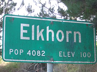
Elkhorn is an unincorporated community and census-designated place (CDP) in Monterey County, California, United States.

Moss Landing, formerly Moss, is an unincorporated community and census-designated place (CDP) in Monterey County, California, United States. It is located 18 miles (29 km) north-northeast of Monterey, at an elevation of 10 feet (3.048 m). It is on the shore of Monterey Bay, at the mouth of Elkhorn Slough and at the head of the submarine Monterey Canyon.
Elkhorn City is a home rule-class city in Pike County, Kentucky, in the United States. The population was 1,035 at the 2020 census. The city is located in proximity to the Breaks Interstate Park.

Elkhorn is a city and the county seat of Walworth County, Wisconsin, United States. It is located 40 miles (64 km) southwest of Milwaukee. As of the 2020 census, it was home to 10,247 people, up from 10,084 at the 2010 census.
Elkhorn or Elk Horn may refer to:

The Elkhorn Mountains are a mountain range, part of the Blue Mountains in the northwest United States. Located in northeastern Oregon west of Baker City, the highest point in the range is Rock Creek Butte at 9,106 feet (2,776 m) above sea level.

The Milwaukee metropolitan area is a major metropolitan area located in Southeastern Wisconsin, consisting of the city of Milwaukee and some of the surrounding area. There are several definitions of the area, including the Milwaukee–Waukesha–West Allis metropolitan area and the Milwaukee–Racine–Waukesha combined statistical area. It is the largest metropolitan area in Wisconsin, and the 39th largest metropolitan area in the United States.

Convoy Range is a broad range in Antarctica. It is south of the Kirkwood Range and north of the Clare Range.
Elkhorn Slough is a 7-mile-long (11 km) tidal slough and estuary on Monterey Bay in Monterey County, California. It is California's second largest estuary and the United States' first estuarine sanctuary. The community of Moss Landing and the Moss Landing Power Plant are located at the mouth of the slough on the bay.
The Elkhorn Wildlife Area is a wildlife management area located near North Powder, Oregon, United States. The large site covers parts of Union and Baker counties, including parts of the Wallowa-Whitman National Forest.
The Elk Hills are a low mountain range in the Transverse Ranges, in western Kern County, California.
The Horseshoe Hills are a roughly crescent-shaped range of hills north of Manhattan, Montana in Gallatin County, Montana. They lie at 6,673 feet (2,034 m) in the area between the southern Big Belt Mountains and the northern Bridger Range. The hills are bounded on the north by Sixteen Mile Creek, the first major tributary of the Missouri River. As they are in the rain shadow of the Boulder, Elkhorn, and Bull Mountains to the west, the Horseshoe Hills are notably dry, receiving 10–12 inches (250–300 mm) of precipitation annually. This is especially true on the southern and southeastern flanks, which are also in the rain shadow of the hills themselves. In the driest areas, Missouri foxtail cacti, plains prickly pear cacti, and yucca abound, as well as prairie rattlesnakes. Much of the hills are private property, but there is also some state, BLM, and National Forest land.
Moss Landing Wildlife Area is a California State wildlife preserve on the shore of Elkhorn Slough.

Carneros Creek is a westward flowing stream and is the primary source of freshwater flowing into Elkhorn Slough. The Carneros Creek official mainstem is 9.8 miles (15.8 km) long. Its source is in the northern Gabilan Range along Highway 101/156 and thus Carneros Creek is an important wildlife corridor from that mountain range in northern San Benito County to Elkhorn Slough, the historic mouth of the Salinas River in Monterey County. Carneros Creek empties into Monterey Bay via Elkhorn Slough at Moss Landing, California.

The August Complex was a massive wildfire that burned in the Coast Range of Northern California, in Glenn, Lake, Mendocino, Tehama, Trinity, and Shasta Counties. The complex originated as 38 separate fires started by lightning strikes on August 16–17, 2020. Four of the largest fires, the Doe, Tatham, Glade, and Hull fires, had burned together by August 30. On September 9, the Doe Fire, the main fire of the August Complex, surpassed the 2018 Mendocino Complex to become both the single-largest wildfire and the largest fire complex in recorded California history. On September 10, the combined Doe Fire also merged with the Elkhorn Fire and the Hopkins Fire, growing substantially in size. By the time it was extinguished on November 12, the August Complex fire had burned a total of 1,032,648 acres (417,898 ha), or 1,614 square miles (4,180 km2), about 1% of California's 100 million acres of land, an area larger than the state of Rhode Island.

