
The Appalachian Mountains, often called the Appalachians, are a mountain range in eastern to northeastern North America. The term "Appalachian" refers to several different regions associated with the mountain range, and its surrounding terrain. The general definition used is one followed by the United States Geological Survey and the Geological Survey of Canada to describe the respective countries' physiographic regions. The U.S. uses the term Appalachian Highlands and Canada uses the term Appalachian Uplands; the Appalachian Mountains are not synonymous with the Appalachian Plateau, which is one of the provinces of the Appalachian Highlands.
The Unaka Range is a mountain range on the border of Tennessee and North Carolina, in the southeastern United States. It is a subrange of the Appalachian Mountains and is part of the Blue Ridge Mountains physiographic province. The Unakas stretch approximately from the Nolichucky River in the south to the Watauga River in the north.

The Unicoi Mountains are a mountain range rising along the border between Tennessee and North Carolina in the southeastern United States. They are part of the Blue Ridge Mountain Province of the Southern Appalachian Mountains. The Unicois are located immediately south of the Great Smoky Mountains and immediately west of the Cheoah Mountains. Most of the range is protected as a national forest, namely the Cherokee National Forest on the Tennessee side and the Nantahala National Forest on the North Carolina side— although some parts have been designated as wilderness areas and are thus more strictly regulated.

The Hudson Highlands are mountains on both sides of the Hudson River in New York state lying primarily in Putnam County on its east bank and Orange County on its west. They continue somewhat to the south in Westchester County and Rockland County, respectively. The highlands are a subrange of the Appalachian Mountains.

The King Range is a mountain range of the Outer Northern California Coast Ranges System, located entirely within Humboldt County on the North Coast of California.

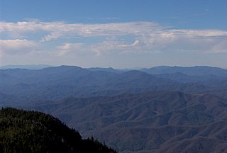
Roan Mountain is a 6,277 ft (1,913 m) mountain straddling the North Carolina/Tennessee border in the Unaka Range of the Southern Appalachian Mountains in the Southeastern United States. The range's highpoint, Roan is clad in a dense stand of Southern Appalachian spruce-fir forest, and includes the world's largest natural rhododendron garden, and the longest stretch of grassy bald in the Appalachian range. The Roan Highlands also contain the highest quality remaining stretch of Fraser fir forest throughout the tree's entire range. The Cherokee National Forest and Pisgah National Forest converge atop the mountain, with Roan Mountain State Park located near its northern base. The Appalachian Trail traverses most of the Roan's crest. The Roan High Knob Shelter is the highest back-country shelter on the entire 2,174-mile (3,499 km) trail.

Andrews Bald is a mountain in the Great Smoky Mountains, located in the southeastern United States. It has an elevation of 5,920 feet (1,800 m) above sea level, making it the highest grassy bald in the Great Smoky Mountains National Park. The mountain is one of two grassy balds maintained in the range by the National Park Service. The other is Gregory Bald, in the western Smokies.

Bald Mountain is a 11,949-foot (3,642 m) peak in the western Uinta Mountain Range in the Uinta-Wasatch-Cache National Forest on the border between Summit and Wasatch counties in northeastern Utah, United States.

Back Allegheny Mountain is a long mountain ridge in eastern West Virginia. It is part of the Shavers Fork Mountain Complex in the Allegheny Range of the Appalachians.

The Great Balsam Mountains, or Balsam Mountains, are in the mountain region of western North Carolina, United States. The Great Balsams are a subrange of the Blue Ridge Mountains, which in turn are a part of the Appalachian Mountains. The most famous peak in the Great Balsam range is Cold Mountain, which is the centerpiece of author Charles Frazier's bestselling novel Cold Mountain. Other notable peaks include Richland Balsam, which is the highest peak in the range, Black Balsam Knob, and Mount Pisgah.

Bald Peak State Scenic Viewpoint is a state park located atop Bald Peak located in Yamhill County, in the United States. The day use only park offers picnic tables and a hiking trail for views of the Willamette Valley and the Cascade Range. The state of Oregon acquired the 26 acres (11 ha) in 1931 after Yamhill and Washington counties requested a park from the state.

The Bald Mountains are a mountain range rising along the border between Tennessee and North Carolina in the southeastern United States. They are part of the Blue Ridge Mountain Province of the Southern Appalachian Mountains. The Bald Mountains stretch from the Pigeon River in the south to the Nolichucky River in the north, and comprise parts of Cocke County, Greene County, and Unicoi County in Tennessee and parts of Madison County and Yancey County in North Carolina. The Great Smoky Mountains border the range to the south, and the Unakas rise opposite the Nolichucky to the north. The range gets its name from the relatively frequent occurrence of grassy balds atop the more prominent summits.

Bald Peak is a mountain top and highest point in the Chehalem Mountains in the Northwest area of the U.S. state of Oregon. Located in Yamhill County near the county line with Washington County, the summit at 1624+ feet is the highest point in the Willamette Valley. Bald Peak State Scenic Viewpoint is a 26-acre (11 ha) state park located on the peak.
South Bald Mountain is the highest summit of the Laramie Mountains in the Rocky Mountains of North America. The summit in Roosevelt National Forest southwest of Red Feather Lakes is the highest of five peaks forming Bald Mountain.

Bald Mountain is a high and prominent mountain summit in the Front Range of the Rocky Mountains of North America. The 13,690-foot (4,173 m) thirteener is located in Arapaho National Forest, 5.5 miles (8.9 km) southeast of the Town of Breckenridge in Summit County, Colorado, United States.
The Hoodoo Mountains are a mountain range in the northwest United States, in north central Idaho. They are part of the Clearwater Mountains and are the source of the Potlatch and Palouse rivers. Located in northeastern Latah County and southeastern Benewah County, the high point is Bald Mountain at 5,334 feet (1,626 m) above sea level. On the west slope of the northern Rocky Mountains, the Hoodoos transition into the adjoining Palouse region, to the southwest.

Hooper Bald is a grassy bald mountain in the Unicoi Mountain Range located in the Cheoah Ranger District of Nantahala National Forest in Graham County, North Carolina, United States. The summit is 5,429 ft/1,655 m.
Blair Mountain is the highest summit of the White River Plateau in the Rocky Mountains of North America. The prominent 11,465-foot (3,495 m) peak is located in White River National Forest, 17.5 miles (28.2 km) north by west of the City of Glenwood Springs in Garfield County, Colorado, United States.
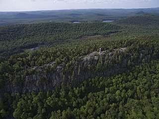
Bald Mountain, or Rondaxe Mountain, is a part of the Adirondack Mountains in the U.S. state of New York. The trail leading up the mountain is a popular hike, likely due to its proximity to tourist towns. The mountain is also home to the Rondaxe Mountain Fire Tower, which contributes to the trail's popularity.
