Sugarloaf Mountain (San Bernardino County, California)

Last updated
Sugarloaf from Highway 38, April 2006. Sugarloaf is the peak on the right. From hwy 38 sugarloaf mt.jpg
Sugarloaf from Highway 38, April 2006. Sugarloaf is the peak on the right.

Sugarloaf Mountain is a large prominent peak in the San Bernardino Mountains in Southern California. With a peak elevation of 9,952 feet (3,033 m), [1] it is the highest peak in the San Bernardino Mountains outside the San Gorgonio Wilderness. [2] Wilderness permits are not required to hike the peak, but a Forest Service pass is required to park on any fire road. Sugarloaf Mountain is clearly visible in most parts of Big Bear Valley. The peak is especially prominent when entering the Big Bear area from Highway 18 from the Lucerne Valley. Located in a unique transition zone in Southern California, the climate is influenced by the deserts, the inland valley, and alpine climates. The north face of the summit is usually covered with snow during the winter months.

San Bernardino Mountains mountain range in Southern California

The San Bernardino Mountains are a high and rugged mountain range in Southern California in the United States. Situated north and northeast of San Bernardino and spanning two California counties, the range tops out at 11,489 feet (3,502 m) at San Gorgonio Mountain – the tallest peak in all of Southern California. The San Bernardinos form a significant region of wilderness and are popular for hiking and skiing.

Southern California Place in California, United States

Southern California is a geographic and cultural region that generally comprises California's southernmost counties, and is the second most populous urban agglomeration in the United States. The region is traditionally described as eight counties, based on demographics and economic ties: Imperial, Los Angeles, Orange, Riverside, San Bernardino, San Diego, Santa Barbara, and Ventura. The more extensive 10-county definition, which includes Kern and San Luis Obispo counties, is also used and is based on historical political divisions.

San Gorgonio Wilderness

The San Gorgonio Wilderness is located in the eastern San Bernardino Mountains, in San Bernardino County and into northern Riverside County, Southern California.

Contents

Flora and fauna

The flora and fauna of Sugarloaf Mountain are representative of a transitional zone between inland desert, mountain, and inland valley climates. The mountain and surrounding forests are home to many rare and endemic plant species. Looming 3,000 feet (910 m) over the southern part of the Big Bear Valley and the village of Sugarloaf, the northern slopes of the mountain are heavily forested with second-growth Jeffrey Pine and White Firs. At higher altitudes on the north-facing slope, Limber and Lodgepole Pines near the summit are twisted into Krummholz formations. The forest on the east facing slope is drier, and the vegetation shows the influence of the Mojave Desert; sagebrush and junipers are more dominant. The southern slope of the mountain is covered in scrubby manzanita bushes and extensive rock scree, with a few hardy Jeffery pines. Snow rarely stays more than few days once the sun shines on the southern face, while the much cooler northern face is covered with snow from early December to late May.

Sugarloaf, California Unincorporated community in California, United States

Sugarloaf is an unincorporated community residential area less than a mile south of Big Bear City and 8 miles from the eastern tip of Big Bear Lake in the San Bernardino Mountains of San Bernardino County, California. The area is primarily residential with a convenience store and a post office located at the center of the community. The residential area is set at an elevation of 7,096 feet at its center, whereas its extreme northern border is 6,998 feet above sea level and the southern tip sits at 7,218 feet above sea level. There is no municipal organization for the area, and all fire, water, and police service is provided by San Bernardino County. The ZIP code for the community is 92386, the area code 909, and the population is 1,816. Big Bear High School is located in the northern part of the community.

Krummholz

Krummholz or krumholtz — also called knieholz — is a type of stunted, deformed vegetation encountered in subarctic and subalpine tree line landscapes, shaped by continual exposure to fierce, freezing winds. Under these conditions, trees can only survive where they are sheltered by rock formations or snow cover. As the lower portion of these trees continues to grow, the coverage becomes extremely dense near the ground. In Newfoundland and Labrador, the formation is known as tuckamore. Krummholz trees are also found on beaches such as the Oregon coast, where trees can become much taller than their subalpine cousins.

Sagebrush

Sagebrush is the common name of several woody and herbaceus species of plants in the genus Artemisia. The best known sagebrush is the shrub Artemisia tridentata. Sagebrushes are native to the North American west.

A year-round spring on the north face forms a small creek that travels to the Greenspot Meadows, which is an excellent birding spot during the spring and summer. The northern slopes were formerly home to herds of wild burros that could be seen from Wildhorse Meadows Road. The Bureau of Land Management removed most of the burros from the Sugarloaf area, but some animals travel there from the lower deserts. Cougars and bears have been spotted in the forests to the west of the peak. In late spring, butterflies may be seen at the rock scree close to the summit.

Bureau of Land Management agency within the United States Department of the Interior

The Bureau of Land Management (BLM) is an agency within the United States Department of the Interior that administers more than 247.3 million acres (1,001,000 km2) of public lands in the United States which constitutes one-eighth of the landmass of the country. President Harry S. Truman created the BLM in 1946 by combining two existing agencies: the General Land Office and the Grazing Service. The agency manages the federal government's nearly 700 million acres (2,800,000 km2) of subsurface mineral estate located beneath federal, state and private lands severed from their surface rights by the Homestead Act of 1862. Most BLM public lands are located in these 12 western states: Alaska, Arizona, California, Colorado, Idaho, Montana, Nevada, New Mexico, Oregon, Utah, Washington and Wyoming.

Mojave Desert desert in southwestern United States

The Mojave Desert is an arid rain-shadow desert and the driest desert in North America. It is in the southwestern United States, primarily within southeastern California and southern Nevada, and it occupies 47,877 sq mi (124,000 km2). Very small areas also extend into Utah and Arizona. Its boundaries are generally noted by the presence of Joshua trees, which are native only to the Mojave Desert and are considered an indicator species, and it is believed to support an additional 1,750 to 2,000 species of plants. The central part of the desert is sparsely populated, while its peripheries support large communities such as Las Vegas, Barstow, Lancaster, Palmdale, Victorville, and St. George.

Related Research Articles

Geography of California

California is a U.S. state on the western coast of North America. Covering an area of 163,696 sq mi (423,970 km2), California is geographically diverse. The Sierra Nevada, the fertile farmlands of the Central Valley, and the arid Mojave Desert of the south are some of the major geographic features of this U.S. state. It is home to some of the world's most exceptional trees: the tallest, most massive, and oldest. It is also home to both the highest and lowest points in the 48 contiguous states. The state is generally divided into Northern and Southern California, although the boundary between the two is not well defined. San Francisco is decidedly a Northern California city and Los Angeles likewise a Southern California one, but areas in between do not often share their confidence in geographic identity. The US Geological Survey defines the geographic center of the state at a point near North Fork, California.

Transverse Ranges mountain range in California

The Transverse Ranges are a group of mountain ranges of southern California, in the Pacific Coast Ranges physiographic region in North America. The Transverse Ranges begin at the southern end of the California Coast Ranges and lie within Santa Barbara, Ventura, Los Angeles, San Bernardino and Riverside counties. The Peninsular Ranges lie to the south. The name Transverse Ranges is due to their east–west orientation, making them transverse to the general northwest–southeast orientation of most of California's coastal mountains.

Ecology of California Environments and natural history of California

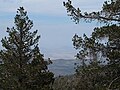
The ecology of California can be understood by dividing the state into a number of ecoregions, which contain distinct ecological communities of plants and animals in a contiguous region. The ecoregions of California can be grouped into four major groups: desert ecoregions, Mediterranean ecoregions, forested mountains, and coastal forests.

San Gorgonio Mountain mountain in United States of America

San Gorgonio Mountain, also known locally as Mount San Gorgonio, or Old Greyback, is the highest peak in Southern California and the Transverse Ranges at 11,503 feet (3,506 m).

San Jacinto Mountains mountain range in Southern California, USA

The San Jacinto Mountains are a mountain range, in Riverside County, east of Los Angeles southern California in the United States. The mountains are named for one of the first Black Friars Saint Hyacinth, who is popular patron in Latin America.

Mount San Antonio mountain

Mount San Antonio, colloquially referred to as Mount Baldy, is the highest peak of the San Gabriel Mountains, and the highest point in Los Angeles County, California. The peak is within the San Gabriel Mountains National Monument and Angeles National Forest. It is the tallest mountain in the Los Angeles metropolitan area. Mount San Antonio's sometimes snow-capped peaks are visible on clear days and dominate the view of the Los Angeles Basin skyline. The peak is pyramid shaped, with a steep south face and a shallower north face. The summit is accessible via a number of connecting ridges along hiking trails from the north, east, south and southwest.

San Bernardino National Forest

The San Bernardino National Forest is a United States National Forest in Southern California encompassing 823,816 acres (3,333.87 km2) of which 677,982 acres (2,743.70 km2) are federal. The forest is made up of two main divisions, the eastern portion of the San Gabriel Mountains and the San Bernardino Mountains on the easternmost of the Transverse Ranges, and the San Jacinto and Santa Rosa Mountains on the northernmost of the Peninsular Ranges. Elevations range from 2,000 to 11,499 feet. The forest includes seven wilderness areas: San Gorgonio, Cucamonga, San Jacinto, South Fork San Jacinto, Santa Rosa, Cahuilla Mountain and Bighorn Mountain. Forest headquarters are located in the city of San Bernardino. There are district offices in Lytle Creek, Idyllwild, and Fawnskin.

Morongo Basin Region of the Inland Empire in Mojave Desert, San Bernardino

The Morongo Basin is an endorheic basin and valley region located in eastern San Bernardino County, in Southern California.

Hot Springs Mountain

Hot Springs Mountain is a peak located in the Peninsular Ranges in California. The mountain rises to an elevation of 6,535 feet (1,992 m) and is the highest point in San Diego County. Some snow falls on the mountain peak during winter. It is located in a remote region of the county, 4 miles from the community of Warner Springs, 12 miles from Borrego Springs, and 50 miles from San Diego. The mountain and its immediate surroundings belong to the Los Coyotes Band of Cahuilla and Cupeno Indians. As of 2011, the mountain can be accessed via a gated dirt road, and prospective hikers are admitted to the reservation subject to a nominal entry fee.

Gearhart Mountain Wilderness

Gearhart Mountain Wilderness is a wilderness area located within the Fremont–Winema National Forest in Lake County and Klamath County in south-central Oregon. This area was established in 1943 as a Wild Area and designated as wilderness with the Wilderness Act of 1964. In 1984, an additional 4,144 acres (1,677 ha) were added for a total of 22,823 acres (9,236 ha). The wilderness is entirely within the Bly Ranger District.

Geography of Arizona

Arizona is a landlocked state situated in the southwestern region of the United States of America. It has a vast and diverse geography famous for its deep canyons, high- and low-elevation deserts, numerous natural rock formations, and volcanic mountain ranges. Arizona shares land borders with Utah to the north, the Mexican state of Sonora to the south, New Mexico to the east, and Nevada to the northwest, as well as water borders with California and the Mexican state of Baja California to the southwest along the Colorado River. Arizona is also one of the Four Corners states and is diagonally adjacent to Colorado.

Pine Valley Mountain Wilderness

Pine Valley Mountain Wilderness is a 50,232-acre (203.28 km2) wilderness area located in the Dixie National Forest in the U.S. state of Utah. It is the fourth-largest wilderness area located entirely within the state. The wilderness designation protects the Pine Valley Mountain range, a large rock outcrop surrounded by desert. The Pine Valley Mountains form the Pine Valley Laccolith, one of the largest laccoliths in the United States. Elevations in the wilderness range from 6,000 feet (1,800 m) to 10,365 feet (3,159 m) at the summit of Signal Peak.

Cascades (ecoregion)

The Cascades ecoregion is a Level III ecoregion designated by the United States Environmental Protection Agency (EPA) in the U.S. states of Washington, Oregon, and California. Somewhat smaller than the Cascade mountain range for which it is named, the ecoregion extends north to Snoqualmie Pass, near Seattle, and south to Hayden Pass, near the Oregon-California border, including the peaks and western slopes of most of the High Cascades. A discontiguous section is located on Mount Shasta in California.

Deserts of California

The Deserts of California have unique ecosystems and habitats, a sociocultural and historical "Old West" collection of legends, districts, and communities, and they also form a popular tourism region of dramatic natural features and recreational development. All of the deserts are located in eastern Southern California, in the Western United States.

Toro Peak mountain in United States of America

Toro Peak, in Southern California, is the highest mountain in the Santa Rosa Mountain Range. It is located 15 mi (24 km) south of Palm Springs, 12 mi (19 km) west of the Salton Sea, and 31 mi (50 km) east of Temecula, California.

Great Basin montane forests

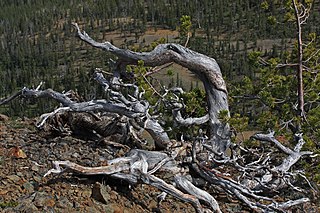
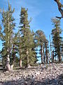
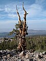
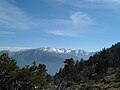
The Great Basin montane forests is an ecoregion of the Temperate coniferous forests biome, as designated by the World Wildlife Fund (WWF).

Sand to Snow National Monument protected area in California

Sand to Snow National Monument is a U.S. National Monument located in San Bernardino County and into northern Riverside County, Southern California.

References