Montserrat is a British Overseas Territory in the Caribbean. The island is in the Leeward Islands, which is part of the chain known as the Lesser Antilles, in the West Indies. Montserrat measures approximately 16 km (10 mi) in length and 11 km (7 mi) in width, with approximately 40 km (25 mi) of coastline. Montserrat is nicknamed "The Emerald Isle of the Caribbean" both for its resemblance to coastal Ireland and for the Irish ancestry of many of its inhabitants. Montserrat is the only non-fully sovereign full member of the Caribbean Community and the Organisation of Eastern Caribbean States.

A volcano is a rupture in the crust of a planetary-mass object, such as Earth, that allows hot lava, volcanic ash, and gases to escape from a magma chamber below the surface.

Minerva Hills is a national park in Central Queensland, Australia, 626 km northwest of Brisbane. Lookouts within the national park overlook the town of Springsure. The park features a rugged landscape with volcanic peaks, sheltered gorges, sheer cliffs, open woodlands and dry rainforest.
Landforms are categorized by characteristic physical attributes such as their creating process, shape, elevation, slope, orientation, rock exposure, and soil type.

A ridge or a mountain ridge is a geographical feature consisting of a chain of mountains or hills that form a continuous elevated crest for some distance. The sides of the ridge slope away from narrow top on either side. The lines along the crest formed by the highest points, with the terrain dropping down on either side, are called the ridgelines. Ridges are usually termed hills or mountains as well, depending on size.
A volcanic field is an area of the Earth's crust that is prone to localized volcanic activity. They usually consist of clusters of up to 100 volcanoes such as cinder cones. Lava flows may also occur. They may occur as a monogenetic volcanic field or a polygenetic volcanic field.
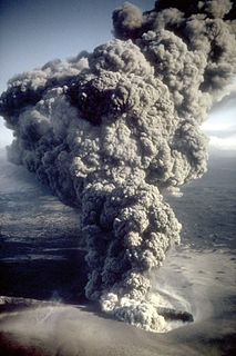
A maar is a broad, low-relief volcanic crater caused by a phreatomagmatic eruption. A maar characteristically fills with water to form a relatively shallow crater lake which may also be called a maar. The name comes from a Moselle Franconian dialect word used for the circular lakes of the Daun area of Germany.

The Soufrière Hills are an active, complex stratovolcano with many lava domes forming its summit on the Caribbean island of Montserrat. After a long period of dormancy, the Soufrière Hills volcano became active in 1995 and has continued to erupt ever since. Its eruptions have rendered more than half of Montserrat uninhabitable, destroying the capital city, Plymouth, and causing widespread evacuations: about two-thirds of the population have left the island. Chances Peak in the Soufrière Hills was the highest summit on Montserrat until the mid-1990s, but it has since been eclipsed by various rising and falling volcanic domes during the recent volcanic activity.

A volcanic plug, also called a volcanic neck or lava neck, is a volcanic object created when magma hardens within a vent on an active volcano. When present, a plug can cause an extreme build-up of pressure if rising volatile-charged magma is trapped beneath it, and this can sometimes lead to an explosive eruption. Glacial erosion can lead to exposure of the plug on one side, while a long slope of material remains on the opposite side. Such landforms are called crag and tail. If a plug is preserved, erosion may remove the surrounding rock while the erosion-resistant plug remains, producing a distinctive upstanding landform.

The geology of the Australian Capital Territory includes rocks dating from the Ordovician around 480 million years ago, whilst most rocks are from the Silurian. During the Ordovician period the region—along with most of eastern Australia—was part of the ocean floor. The area contains the Pittman Formation consisting largely of Quartz-rich sandstone, siltstone and shale; the Adaminaby Beds and the Acton Shale.
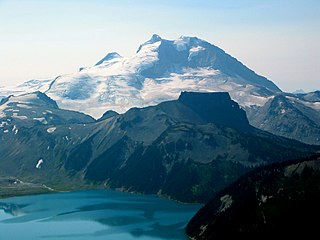
Tuber Hill is a small 600,000-year-old basaltic stratovolcano that was constructed on the Bridge River highlands when nearby valleys were packed with ice. Tuber Hill is part of the Garibaldi segment of the Canadian Cascade Arc, but is not in the geographic Cascade Range.
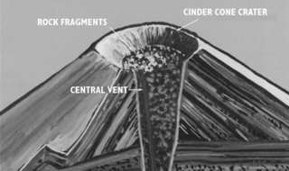
A cinder cone is a steep conical hill of loose pyroclastic fragments, such as volcanic clinkers, volcanic ash, or cinder that has been built around a volcanic vent. The pyroclastic fragments are formed by explosive eruptions or lava fountains from a single, typically cylindrical, vent. As the gas-charged lava is blown violently into the air, it breaks into small fragments that solidify and fall as either cinders, clinkers, or scoria around the vent to form a cone that often is symmetrical; with slopes between 30–40°; and a nearly circular ground plan. Most cinder cones have a bowl-shaped crater at the summit.
Outcast Hill is an isolated hill in northern British Columbia, Canada, located southeast of Mess Lake. It lies at the southern end of Mount Edziza Provincial Park.

Volcanism of Western Canada has produced lava flows, lava plateaus, lava domes, cinder cones, stratovolcanoes, shield volcanoes, greenstone belts, submarine volcanoes, calderas, diatremes and maars, along with examples of more less common volcanic forms such as tuyas and subglacial mounds.
Exile Hill is an isolated hill in the Spectrum Range of northern British Columbia, Canada, located southeast of Mess Lake. It lies at the southern end of Mount Edziza Provincial Park.
Tadekho Hill is an isolated hill in the Spectrum Range of northern British Columbia, Canada, located 64 km (40 mi) southwest of Tatogga and 10 km (6 mi) southwest of Kitsu Peak. It lies at the southwestern end of Mount Edziza Provincial Park.

The Canelo Hills are a range of low mountains or hills in eastern Santa Cruz County, Arizona. The range consists of a series of northwest–southeast trending ridges extending from the Sonoita Creek valley southwest of Sonoita to the Parker Canyon Lake area in southwest Cochise County, Arizona. The Canelo Hills merge with the Huachuca Mountains to the southeast. The San Rafael Valley lies to the southwest of the range and the Patagonia Mountains lie to the west across the Harshaw Creek valley. The Canelo Hills Cienega Reserve and the ghost town of Canelo, Arizona, are located on the eastern side of the hills.

Scawt Hill is a volcanic plug in County Antrim, Northern Ireland, in the borough of Larne, 5 km from the village of Ballygally.
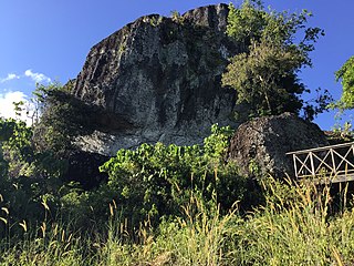
Skull Hill is an archaeological site hill located at Tampi Tampi Road, about 10 kilometres (6.2 mi) south of Semporna town.
