
The Salt River is a river in Gila and Maricopa counties in Arizona, United States, that is the largest tributary of the Gila River. The river is about 200 miles (320 km) long. Its drainage basin covers about 13,700 square miles (35,000 km2). The longest of the Salt River's many tributaries is the 195-mile (314 km) Verde River. The Salt's headwaters tributaries, the Black River and East Fork, increase the river's total length to about 300 miles (480 km). The name Salt River comes from the river's course over large salt deposits shortly after the merging of the White and Black Rivers.

The Shenandoah River is the principal tributary of the Potomac River, 55.6 miles (89.5 km) long with two forks approximately 100 miles (160 km) long each, in the U.S. states of Virginia and West Virginia. The river and its tributaries drain the central and lower Shenandoah Valley and the Page Valley in the Appalachians on the west side of the Blue Ridge Mountains, in northwestern Virginia and the Eastern Panhandle of West Virginia. There is a hydroelectric plant along the Shenandoah river constructed in 2014 by Dominion.

Mount Jefferson is a mountain located on the Continental Divide between Fremont County of northeastern Idaho and Beaverhead County of southwestern Montana. Mount Jefferson is the highest point of the Centennial Mountains, whose crest runs along the Continental Divide and can be climbed using a class 2 route (scramble) from the access road to neighboring Sawtell Peak.

Deep Creek Lake State Park is a public recreation area occupying more than 1,100 acres (450 ha) on the northeast side of Deep Creek Lake in Garrett County, Maryland, in the United States. The park features water activities, camping facilities, and recreational trails and is located about 18 miles (29 km) south of Interstate 68 on U.S. Route 219.

The Fish Creek Mountains Wilderness is located about 25 miles west of Brawley, California, and southeast of the Vallecito Mountains in the United States. The wilderness is located in the Fish Creek Mountains region in the northern part of the Carrizo Impact Area, which is closed to the public.
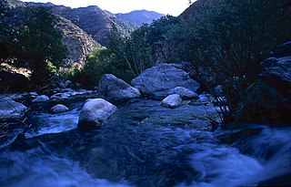
Piru Creek is a major stream, about 71 miles (114 km) long, in northern Los Angeles County and eastern Ventura County, California. It is a tributary of the Santa Clara River, the largest stream system in Southern California that is still relatively natural.
Mountain Creek Lake is a reservoir located 8 miles (13 km) southwest of Downtown Dallas, Texas, United States, in the Mountain Creek area of the city. It is located south of SH 180, west of Spur 408, north of I-20, and east of FM 1382. The defunct Naval Air Station Dallas, now an Armed Forces Reserve Center, is located on the northern shore of the lake. Mountain Creek Lake Park is on the lake's southeastern and southwestern edges.
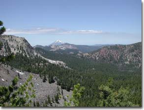
The Mountain Lakes Wilderness is a wilderness area located in the Fremont–Winema National Forest in the southern Cascade Range of Oregon in the United States. It surrounds a cluster of four overlapping shield volcanoes, the highest of which is 8,208-foot (2,502 m) Aspen Butte. Over 20 small lakes lie along the bottoms of several large cirques carved by Ice Age glaciers near the summits of the volcanoes.

Boulder Creek is a 31.4-mile-long (50.5 km) creek draining the Rocky Mountains to the west of Boulder, Colorado, as well as the city itself and surrounding plains.
Gore Mountain is a mountain located near the village of North Creek in Warren County, New York, of which its peak is the highest point. Gore is flanked to the north by South Mountain, and to the southwest by Height of Land Mountain. The mountain is the site of the popular Gore Mountain ski resort. The mountain is the site of the Gore Mountain Fire Observation Station which was built in 1918.

Uvas Creek is a 29.5-mile-long (47.5 km) mainly southward-flowing stream originating on Loma Prieta peak of the Santa Cruz Mountains, in Santa Clara County, California, United States. The creek descends through Uvas Canyon County Park into Uvas Reservoir near Morgan Hill, and on through Uvas Creek Preserve and Christmas Hill Park in Gilroy. Upon passing U.S. Highway 101 it is known as Carnadero Creek, shortly before the confluence with the Pajaro River at the Santa Clara County - San Benito County boundary.

The Trout Creek Mountains are a remote, semi-arid Great Basin mountain range mostly in southeastern Oregon and partially in northern Nevada in the United States. The range's highest point is Orevada View Benchmark, 8,506 feet (2,593 m) above sea level, in Nevada. Disaster Peak, elevation 7,781 feet (2,372 m), is another prominent summit in the Nevada portion of the mountains.

Little Butte Creek is a 17-mile-long (27 km) tributary of the Rogue River in the U.S. state of Oregon. Its drainage basin consists of approximately 354 square miles (917 km2) of Jackson County and another 19 square miles (49 km2) of Klamath County. Its two forks, the North Fork and the South Fork, both begin high in the Cascade Range near Mount McLoughlin and Brown Mountain. They both flow generally west until they meet near Lake Creek. The main stem continues west, flowing through the communities of Brownsboro, Eagle Point, and White City, before finally emptying into the Rogue River about 3 miles (5 km) southwest of Eagle Point.

The Bitter Creek National Wildlife Refuge is located in the foothills of the southwestern San Joaquin Valley in Kern County, California. The refuge is one of four units of the Hopper Mountain National Wildlife Refuge Complex for California condors.
The Pierce National Wildlife Refuge is in southwest Washington within the Columbia River Gorge National Scenic Area. It encompasses wetlands and uplands along the north shore of the Columbia River west of the town of North Bonneville. Refuge habitats include wetlands, Columbia River riparian corridor blocks, transitional woodlands from willows to cottonwood/ash to white oak to Douglas fir, improved pastures with some native grasses, and numerous creeks, seeps, and springs.

McKay Creek National Wildlife Refuge is a United States National Wildlife Refuge located between plains and the Blue Mountains of Eastern Oregon. The refuge provides habitat for rare and endangered species and breeding and migratory birds. The lack of other local wetland habitats elevates the importance of this refuge as a home to a variety of wildlife and plant species in an arid environment.

The South Fork Eel River Wilderness is a 12,868-acre (5,207 ha) wilderness area located in Mendocino County, California. The wilderness was added to the National Wilderness Preservation System when the United States Congress passed the Northern California Coastal Wild Heritage Wilderness Act in 2006. The Department of the Interior's Bureau of Land Management (BLM) is the agency in charge.
Lost Creek State Park is a 502-acre (203 ha) public recreation area in Deer Lodge County, Montana, United States, about 6 miles (9.7 km) north of Anaconda.
The Matilija Wilderness is a 29,207-acre (11,820 ha) wilderness area in Ventura and Santa Barbara Counties, Southern California. It is managed by the U.S. Forest Service, being situated within the Ojai Ranger District of the Los Padres National Forest. It is located adjacent to the Dick Smith Wilderness to the northwest and the Sespe Wilderness to the northeast, although it is much smaller than either one. The Matilija Wilderness was established in 1992 in part to protect California condor habitat.
