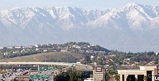
Corona is a city in Riverside County, California, United States. As of the 2020 census, the city had a population of 157,136, up from 152,374 at the 2010 census. The cities of Norco and Riverside lie to the north and northeast, Chino Hills and Yorba Linda to the northwest, Anaheim to the west, Cleveland National Forest and the Santa Ana Mountains to the southwest, and unincorporated Riverside County along the rest of the city's borders. Corona is approximately 48 miles southeast of Downtown Los Angeles and 95 miles (153 km) north-northwest of San Diego.

The Mojave River is an intermittent river in the eastern San Bernardino Mountains and the Mojave Desert in San Bernardino County, California, United States. Most of its flow is underground, while its surface channels remain dry most of the time, with the exception of the headwaters and several bedrock gorges in the lower reaches.

Steens Mountain is in the southeastern part of the U.S. state of Oregon, and is a large fault-block mountain. Located in Harney County, it stretches some 50 miles (80 km) north to south, and rises from alongside the Alvord Desert at elevation of about 4,200 feet (1,300 m) to a summit elevation of 9,738 feet (2,968 m). It is sometimes confused with a mountain range but is properly a single mountain.

The Alvord Desert is a desert located in Harney County, in southeastern Oregon in the western United States. It is roughly southeast of Steens Mountain. The Alvord Desert is a 12-by-7-mile dry lake bed and averages 7 inches (180 mm) of rain a year. Two mountain ranges separate it from the Pacific Ocean—the Coast Range, and the Cascade Mountains. Along with Steens Mountain, these topographical features create a rain shadow. The Alvord Desert lies at an elevation of approximately 4,000 feet (1,200 m).
The Snake War (1864–1868) was an irregular war fought by the United States of America against the "Snake Indians," the settlers' term for Northern Paiute, Bannock and Western Shoshone bands who lived along the Snake River. Fighting took place in the states of Oregon, Nevada, and California, and in Idaho Territory. Total casualties from both sides of the conflict numbered 1,762 dead, wounded, or captured.

Benjamin Alvord was an American soldier, mathematician, and botanist.
The Bank of California was opened in San Francisco, California, on July 4, 1864, by William Chapman Ralston and Darius Ogden Mills. It was the first commercial bank in the Western United States, the second-richest bank in the nation, and considered instrumental in developing the American Old West.

The Old Spanish Trail is a historical trade route that connected the northern New Mexico settlements of Santa Fe, New Mexico with those of Los Angeles, California and southern California. Approximately 700 mi (1,100 km) long, the trail ran through areas of high mountains, arid deserts, and deep canyons. It is considered one of the most arduous of all trade routes ever established in the United States. Explored, in part, by Spanish explorers as early as the late 16th century, the trail was extensively used by traders with pack trains from about 1830 until the mid-1850s.

The Crescenta Valley is a small inland valley in Los Angeles County, California, lying between the San Gabriel Mountains on the northeast and the Verdugo Mountains and San Rafael Hills on the southwest. It opens into the San Fernando Valley at the northwest and the San Gabriel Valley at the southeast. It is nearly bisected by the Verdugo Wash, a smaller valley separating the Verdugo Mountains from the San Rafael Hills. Most of the valley lies at an elevation of over 1,500 feet.
The Alvord cutthroat trout, Oncorhynchus clarki alvordensis, was a subspecies of cutthroat trout. It was known only from Trout Creek in Oregon and Virgin Creek in Nevada, although it may have lived in several of the larger Alvord Basin streams during recent times. It was native to spring-fed creeks that ran down to Alvord Dry Lake in southeast Oregon, which was a large lake during the ice ages and an isolated drainage, part of the Great Basin today. This is one of the two cutthroat trout taxa considered extinct because all known populations are hybridized with rainbow trout which were introduced into streams in the Alvord basin in the 1920s, resulting in cutbows.

William Alvord was a San Francisco merchant, banker and political leader. He was the 13rd Mayor of San Francisco from 1871 to 1873 and served as president of the Bank of California from 1878 until his death.
Alvord Unified School District (AUSD) is a school district headquartered in Riverside, California, United States.

Double Mountain is the highest point in the Tehachapi Mountains of California. It has two summits of nearly the same elevation. It is south of the town of Tehachapi, Highway 58 and Tehachapi Pass. Due to its elevation, the mountain receives snowfall during the winter.

Alvord Lake is a seasonal shallow alkali lake in Harney County of the U.S. state of Oregon. Its elevation is 4,026 feet (1,227 m). It is located about 10 miles (16 km) southeast of Alvord Desert in the Alvord Basin and serves as terminus for all its streams. Its water level varies from dry to several feet deep. The nearest habitation is tiny Fields, 14.1 kilometres (8.8 mi) SSW.

Zurich is a former settlement in Inyo County, California. It was a stop of the Carson and Colorado Railway. It is located 2 miles (3 km) northeast of Big Pine, at an elevation of 3934 feet.

The Fairbank train robbery occurred on the night of February 15, 1900, when some bandits attempted to hold up a Wells Fargo express car at the town of Fairbank, Arizona. Although it was thwarted by Jeff Milton, who managed to kill "Three Fingered Jack" Dunlop in an exchange of gunfire, the train robbery was unique for being one of the few to have occurred in a public place and was also one of the last during the Old West period.
Bitter Spring is a spring within the Fort Irwin National Training Center in San Bernardino County, California. It lies at an elevation of 1355 feet and is located in a valley between the Soda Mountains to the east, the Tiefort Mountains to the northwest, Alvord Mountain to the southwest and Cronese Mountains to the south and southeast.
Impassable Pass is a gap in Alvord Mountain, in San Bernardino County, California. It is located just south and outside of the boundary fence of Fort Irwin National Training Center.
Spanish Canyon, is a canyon that has its head near the middle of the southwest slope of Alvord Mountain below Impassable Pass at 35°07′10″N116°35′37″W and trends south to its mouth, 1.6 miles east northeast of Alvord Well at an elevation of 2, 188 feet / 667 meters. The canyon is named for the Old Spanish Trail which passed through the canyon.
