Related Research Articles

The Mojave River is an intermittent river in the eastern San Bernardino Mountains and the Mojave Desert in San Bernardino County, California, United States. Most of its flow is underground, while its surface channels remain dry most of the time, except for the headwaters and several bedrock gorges in the lower reaches.
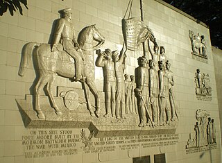
The Mormon Battalion was the only religious unit in United States military history in federal service, recruited solely from one religious body and having a religious title as the unit designation. The volunteers served from July 1846 to July 1847 during the Mexican–American War of 1846–1848. The battalion was a volunteer unit of between 534 and 559 Latter-day Saint men, led by Mormon company officers commanded by regular U.S. Army officers. During its service, the battalion made a grueling march of nearly 2,100 miles from Council Bluffs, Iowa, to San Diego, California.

The California Trail was an emigrant trail of about 1,600 mi (2,600 km) across the western half of the North American continent from Missouri River towns to what is now the state of California. After it was established, the first half of the California Trail followed the same corridor of networked river valley trails as the Oregon Trail and the Mormon Trail, namely the valleys of the Platte, North Platte, and Sweetwater rivers to Wyoming. The trail has several splits and cutoffs for alternative routes around major landforms and to different destinations, with a combined length of over 5,000 mi (8,000 km).

The Old Spanish Trail is a historical trade route that connected the northern New Mexico settlements of Santa Fe, New Mexico with those of Los Angeles, California and southern California. Approximately 700 mi (1,100 km) long, the trail ran through areas of high mountains, arid deserts, and deep canyons. It is considered one of the most arduous of all trade routes ever established in the United States. Explored, in part, by Spanish explorers as early as the late 16th century, the trail was extensively used by traders with pack trains from about 1830 until the mid-1850s.

The Mojave Road, also known as Old Government Road, is a historic route and present day dirt road across what is now the Mojave National Preserve in the Mojave Desert in the United States. This rough road stretched 147 miles (237 km) from Beale's Crossing, to Fork of the Road location along the north bank of the Mojave River where the old Mojave Road split off from the route of the Old Spanish Trail/Mormon Road.
In the history of the American frontier, overland trails were built by pioneers throughout the 19th century and especially between 1829 and 1870 as an alternative to sea and railroad transport. These immigrants began to settle much of North America west of the Great Plains as part of the mass overland migrations of the mid-19th century. Settlers emigrating from the eastern United States were spurred by various motives, among them religious persecution and economic incentives, to move to destinations in the far west via routes including the Oregon Trail, California Trail, and Mormon Trail. After the end of the Mexican–American War in 1849, vast new American conquests again enticed mass immigration. Legislation like the Donation Land Claim Act and significant events like the California Gold Rush further lured people to travel overland to the west.
William Taylor Barnes Sanford (1814–1863) was an American road builder, a landowner and the second postmaster of Los Angeles, California, after it became a part of the United States. He was a member of the Los Angeles Common Council in 1853–54.

Glen Helen Regional Park is a county park located in San Bernardino, California, United States adjacent to the Cajon Pass. It was the site of both US Festivals of the early 1980s. It is also home to the Glen Helen Amphitheater, the largest outdoor amphitheater in the United States. The park also hosts several off-road races since 1985.

Peteetneet Creek is a stream in Payson Canyon, south of Payson, Utah, United States.
Bitter Spring is a spring within the Fort Irwin National Training Center in San Bernardino County, California. It lies at an elevation of 1355 feet and is located in a valley between the Soda Mountains to the east, the Tiefort Mountains to the northwest, Alvord Mountain to the southwest and Cronese Mountains to the south and southeast.
Impassable Pass is a gap in Alvord Mountain, in San Bernardino County, California. It is located just south and outside of the boundary fence of Fort Irwin National Training Center.
Red Pass is a gap in the Avawatz Mountains, in San Bernardino County, California. Red Pass, lies between the Silurian Valley and the valley drained by an as yet unnamed tributary of Salt Creek, which drains much of the area of Fort Irwin National Training Center, through Red Pass into the Silurian Valley and into the Amargosa River in Death Valley.
Camp Spring, is a spring, in Washington County, Utah. It lies at an elevation of 3,435 feet/1,047 meters in the reservation of the Shivwits Band of Paiutes.
Emigrant Pass, is a gap in the Nopah Range of Inyo County, California. It lies at an elevation of 2,884 feet (879 m) in the Nopah Range between Chicago Valley to the west and California Valley to the east.
Crowder Canyon, originally Coyote Canyon, is a valley in San Bernardino County, California. Its mouth was at an elevation of 2,999 feet / 914 meters at its confluence with Cajon Canyon. Its source was at an elevation of 4200 feet at 34°21′02″N117°26′04″W near Cajon Summit. The canyon runs southward just west of the top of Cajon Pass then turns southwestward to meet Cajon Canyon.
Fork of the Road was the locale along the Mojave River where the junction of the Mojave Trail / Mojave Road and the Old Spanish Trail / Mormon Road was located in San Bernardino County, California. The location of Fork of the Road was on the north side of the Mojave River, 18.75 miles southwest of Bitter Spring, about 14.5 miles east of Grapevine, and 10.9 miles west of Camp Cady. The location was an oasis where the Mojave River came to the surface. There travelers could get water, camp, rest and graze their animals before or after crossing the desert.

The Mohave Trail was a Native American trade route between Mohave Indian villages on the Colorado River and settlements in coastal Southern California.
Utah Hill Summit is a summit and a gap in the Beaver Dam Mountains in Washington County, Utah. It lies at an elevation of 4,731 / 1,442 meters.
Mormon Road, also known to the 49ers as the Southern Route, of the California Trail in the Western United States, was a seasonal wagon road pioneered by a Mormon party from Salt Lake City, Utah led by Jefferson Hunt, that followed the route of Spanish explorers and the Old Spanish Trail across southwestern Utah, northwestern Arizona, southern Nevada and the Mojave Desert of California to Los Angeles in 1847. From 1855, it became a military and commercial wagon route between California and Utah, called the Los Angeles – Salt Lake Road. In later decades this route was variously called the "Old Mormon Road", the "Old Southern Road", or the "Immigrant Road" in California. In Utah, Arizona and Nevada it was known as the "California Road".
Salt Spring, sometimes called Salt Springs, was a spring in the Mojave Desert, in San Bernardino County, California. It was a spring along the course of Salt Creek a tributary of the Amargosa River.
References
- ↑ U.S. Geological Survey Geographic Names Information System: Spanish Canyon
- ↑ Edward Leo Lyman, Overland Journey from Utah to California: Wagon Travel from the City of Saints to the City of Angels, University of Nevada Press, 2008.
Coordinates: 35°03′09″N116°35′39″W / 35.05250°N 116.59417°W
| | This American Old West-related article is a stub. You can help Wikipedia by expanding it. |