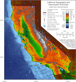
California is a U.S. state on the western coast of North America. Covering an area of 163,696 sq mi (423,970 km2), California is among the most geographically diverse states. The Sierra Nevada, the fertile farmlands of the Central Valley, and the arid Mojave Desert of the south are some of the geographic features of this U.S. state. It is home to some of the world's most exceptional trees: the tallest, most massive, and oldest. It is also home to both the highest and lowest points in the 48 contiguous states.

The Santa Cruz Mountains are a mountain range in central and Northern California, United States, constituting a part of the Pacific Coast Ranges. They form a ridge down the San Francisco Peninsula, south of San Francisco. They separate the Pacific Ocean from the San Francisco Bay and the Santa Clara Valley, and continue south to the Central Coast, bordering Monterey Bay and ending at the Salinas Valley. The range passes through the counties of San Mateo, Santa Clara, and Santa Cruz, with the Pajaro River forming the southern boundary.

Black Mountain, also known as Mount Day, is a mountain in the Diablo Range of eastern Santa Clara County, California, east of Poverty Ridge and Arroyo Hondo, and about 10 miles (16 km) from Milpitas.

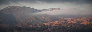
The Diablo Range is a mountain range in the California Coast Ranges subdivision of the Pacific Coast Ranges in northern California, United States. It stretches from the eastern San Francisco Bay Area at its northern end to the Salinas Valley area at its southern end.
Los Buellis Hills are a short sub−range of hills in the northwestern Diablo Range, in the South Bay region of the San Francisco Bay Area, within Santa Clara County, California.
The San Ramon Valley is a valley and region in Contra Costa County and Alameda County, in the East Bay region of the San Francisco Bay Area in northern California.

The Berkeley Hills are a component of the East Bay Hills, a range of the Pacific Coast Ranges, and overlook the northeast side of the valley that encompasses San Francisco Bay. They were previously called the "Contra Costa Range/Hills", but with the establishment of Berkeley and the University of California, the current usage was applied by geographers and gazetteers.

The Gabilan Range or Gabilán Range are a mountain range in the inner California Coast Ranges System, located in Monterey County and San Benito County of central California. Pinnacles National Park is located in the southern section of the range.

The San Benito River is a 109 miles (175 km) long river flowing northwesterly between the Diablo Range and the Gabilan Range, on the Central Coast of California. The river begins in southeasternmost San Benito County, California and ends in the extreme northwestern part of the county, where it is a tributary to the Pajaro River. The San Benito River is longer than the Pajaro River and it drains more area, although it has proportionally lower flows.
The East Bay Hills is a mountain range in the California Coast Ranges subdivision of the Pacific Coast Ranges in northern California, United States. They are the first range of mountains east of San Francisco Bay and stretch from the Carquinez Strait in the north to Alameda Creek/Highway 84 in the south, crossing both Contra Costa and Alameda Counties. Although not formally recognized by United States Geological Survey (USGS) Geographic Names Information System, the East Bay Hills is included as part of the Diablo Range in its list of multiple GPS coordinates for the latter.

Pleasanton Ridge Regional Park is a 5,271-acre (21.33 km2) park in the East Bay Regional Park District overlooking Pleasanton, California and the Livermore Valley to the east. The park is scheduled to grow by almost 1,500 acres (6.1 km2) (sic) with the acquisition of the Tyler Ranch.

Uvas Creek is a 29.5-mile-long (47.5 km) mainly southward-flowing stream originating on Loma Prieta peak of the Santa Cruz Mountains, in Santa Clara County, California, United States. The creek descends through Uvas Canyon County Park into Uvas Reservoir near Morgan Hill, and on through Uvas Creek Preserve and Christmas Hill Park in Gilroy. Upon passing U.S. Highway 101 it is known as Carnadero Creek, shortly before the confluence with the Pajaro River at the Santa Clara County - San Benito County boundary.

The Briones Hills form a low mountain range in western Contra Costa County, in the East Bay region of the San Francisco Bay Area, California, United States. The Briones Hills are the northernmost portion of the East Bay Hills, which refers geologically to all of the ranges east of the Bay from the Hayward Fault in the west to the Calaveras Fault in the east. The United States Geological Survey (USGS) Geographic Names Information System, however, includes the Briones Hills as part of the Diablo Range in its list of GPS coordinates for the latter.

The Santa Teresa Hills are a range of mountains in Santa Clara County, California, located primarily in the city of San Jose. They separate the San Jose neighborhoods of Almaden Valley to the west and Santa Teresa to the east.

The Juab Valley is a 40-mile (64 km) long valley located on the eastern edge of Juab County, Utah, United States.

Tulare Hill is a prominent hill in the Santa Teresa Hills of western Santa Clara County, California. It lies along the southernmost edge of San Jose, California, adjacent to the Metcalf Energy Center. The hill and surrounding 330 acres (130 ha) of serpentine grasslands are home to the endangered Bay checkerspot butterfly and Dudleya setchellii wildflower. A portion of the hill makes up the Tulare Hill Ecological Preserve.
San Felipe Creek is a 14 miles (23 km) stream that originates in the western Diablo Range in Santa Clara County, California. It flows south by southeast through two historic ranchos, Rancho Los Huecos and Rancho Cañada de San Felipe y Las Animas before it joins Las Animas Creek just above Anderson Reservoir. One of the nine major tributaries of Coyote Creek, the creek's waters pass through the Santa Clara Valley and San Jose on the way to San Francisco Bay.
Arroyo Bayo is an 8-mile-long (13 km) perennial stream which flows northwest along Mount Hamilton Road east of Mt. Hamilton in the Diablo Range. It is part of the southern Alameda Creek watershed in Santa Clara County, California.
Arroyo Viejo is a westward flowing 5.1 miles (8.2 km) creek that begins in the Oakland Hills in Alameda County, California, and joins Lion Creek just before entering San Leandro Bay, a part of eastern San Francisco Bay.
Mount Diablo Creek is a 14.3-mile-long (23.0 km) northwest-flowing stream originating on the north flank of Mount Diablo. Its dozen small tributaries gather near Clayton before flowing through Concord and the Concord Naval Weapons Station, ultimately ending in tidelands on the southern shore of Suisun Bay in Contra Costa County. If the Concord Naval Weapons Station is converted to protected wildlands, Mount Diablo Creek may serve as the last wildlife corridor for black-tailed deer, tule elk, and other mammals from Mount Diablo to Suisun Bay.


