
The term "United States," when used in the geographical sense, refers to the contiguous United States, Alaska, Hawaii, the five insular territories of Puerto Rico, Northern Mariana Islands, U.S. Virgin Islands, Guam, American Samoa, and minor outlying possessions. The United States shares land borders with Canada and Mexico and maritime borders with Russia, Cuba, The Bahamas, and many other countries, mainly in the Caribbeanin addition to Canada and Mexico. The northern border of the United States with Canada is the world's longest bi-national land border.

Southern California is a geographic and cultural region that generally comprises the southern portion of the U.S. state of California. It includes the Los Angeles metropolitan area as well as the Inland Empire. The region generally contains ten of California's 58 counties: Imperial, Kern, Los Angeles, Orange, Riverside, San Bernardino, San Diego, Santa Barbara, San Luis Obispo, and Ventura counties.

San Ardo, formerly known as San Bernardo, is an unincorporated community and census-designated place (CDP) in Monterey County, California, United States. San Ardo is located 18 miles (29 km) southeast of King City at an elevation of 449 feet (137 m). The population was 392 at the 2020 census, down from 517 in 2010.

The Pacific Coast Ranges are the series of mountain ranges that stretch along the West Coast of North America from Alaska south to Northern and Central Mexico. Although they are commonly thought to be the westernmost mountain range of the continental United States and Canada, the geologically distinct Insular Mountains of Vancouver Island lie farther west.

The Black Rock Desert is a semi-arid region of lava beds and playa, or alkali flats, situated in the Black Rock Desert–High Rock Canyon Emigrant Trails National Conservation Area, a silt playa 100 miles (160 km) north of Reno, Nevada, that encompasses more than 300,000 acres (120,000 ha) of land and contains more than 120 miles (200 km) of historic trails. It is in the northern Nevada section of the Great Basin with a lakebed that is a dry remnant of Pleistocene Lake Lahontan.

The Santa Monica Mountains are a coastal mountain range in Southern California, next to the Pacific Ocean. It is part of the Transverse Ranges. The Santa Monica Mountains National Recreation Area encompasses this mountain range. Because of its proximity to densely populated regions, it is one of the most visited natural areas in California.

Parkfield is an unincorporated community in Monterey County, California. It is located on Little Cholame Creek 21 miles (34 km) east of Bradley, at an elevation of 1,529 feet (466 m). As of 2007, road signs announce the population as 18.
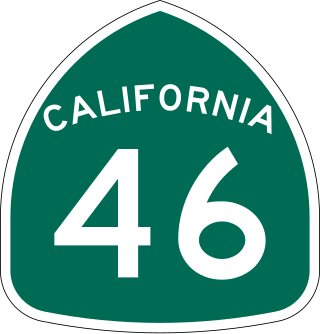
State Route 46 is an east–west state highway in the U.S. state of California. It is a major crossing of the Coast Ranges and it is the southernmost crossing of the Diablo Range, connecting SR 1 on the Central Coast near Cambria and US 101 in Paso Robles with SR 99 at Famoso in the San Joaquin Valley.
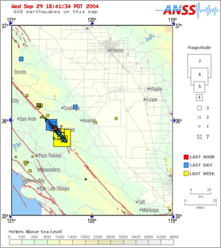
Parkfield earthquake is a name given to various large earthquakes that occurred in the vicinity of the town of Parkfield, California, United States. The San Andreas fault runs through this town, and six successive magnitude 6 earthquakes occurred on the fault at unusually regular intervals, between 12 and 32 years apart, between 1857 and 1966. The most recent significant earthquake to occur here happened on September 28, 2004.
The 1857 Fort Tejon earthquake occurred at about 8:20 a.m. on January 9 in central and Southern California. One of the largest recorded earthquakes in the United States, with an estimated moment magnitude of 7.9, it ruptured the southern part of the San Andreas Fault for a length of about 225 miles, between Parkfield and Wrightwood.

State Route 41 is a state highway in the U.S. State of California, connecting the Central Coast with the San Joaquin Valley and the Sierra Nevada. Its southern terminus is at the Cabrillo Highway in Morro Bay, and its northern terminus is at SR 140 in Yosemite National Park. It has been constructed as an expressway from near SR 198 in Lemoore north to the south part of Fresno, where the Yosemite Freeway begins, passing along the east side of downtown and extending north into Madera County.

The Diablo Range is a mountain range in the California Coast Ranges subdivision of the Pacific Coast Ranges in northern California, United States. It stretches from the eastern San Francisco Bay Area at its northern end to the Salinas Valley area at its southern end.
Cholame is an unincorporated community in San Luis Obispo County, California, United States. It sits within a mile of the San Andreas Fault at an elevation of 1,157 feet (353 m) above sea level.

The Temblor Range is a mountain range within the California Coast Ranges, at the southwestern extremity of the San Joaquin Valley in California in the United States. It runs in a northwest-southeasterly direction along the borders of Kern County and San Luis Obispo County. The name of the range is from Spanish temblor meaning "tremor", referring to earthquakes. The San Andreas Fault Zone runs parallel to the range at the base of its western slope, on the eastern side of the Carrizo Plain, while the Antelope Plain, location of the enormous Midway Sunset, South Belridge, and Cymric oil fields, lies to the northeast.
The Estrella River is a 28.5-mile-long (45.9 km) tributary river in eastern San Luis Obispo County, California. The river forms at the confluence of Cholame Creek, from the north, and San Juan Creek, from the south, near the town of Shandon. From there it flows west-northwest to its confluence with the Salinas River, of which it is a tributary, 8 miles north of Paso Robles. Cholame Creek has its headwaters on the southwest side of Middle Mountain and its tributary, Little Cholame Creek, begins on the northeast side. The creek drains the Cholame Valley, which is bordered by Diablo Range on the east and Cholame Hills, a northern extension of the Temblor Range, on the west. The average precipitation in the area ranges from 11 to 17 inches, increasing northward.

The Palos Verdes Hills are a low mountain range on the southwestern coast of Los Angeles County, California. They sit atop the Palos Verdes Peninsula, a sub-region of the Los Angeles metropolitan area.
Rancho Cholame was a 26,622-acre (107.74 km2) Mexican land grant in present-day Monterey County and San Luis Obispo County, California given in 1844 by Governor Manuel Micheltorena to Mauricio Gonzales. The grant extended along the Cholame Valley, and encompassed present day Cholame.

Little Cholame Creek is a perennial stream in southeastern Monterey County, California, United States. The headwaters rise from an unnamed peak 2 miles southwest of Reason Mountain, in the southern part of the Diablo Range. From there, the creek flows southeast along Parkfield-Coalinga Road, before reaching confluence with Cholame Creek.
Mustang Peak is a summit in the Diablo Range on the northwest - southeast trending range of mountains marking the boundary of Monterey County and Fresno County, California. This summit rises to an elevation of 3,596 feet. It overlooks the Kreyenhagen Hills and Kettleman Plain beyond it to the east, and the Jacalitos Hills and Pleasant Valley beyond it to the north. To the south is Joaquin Canyon, tributary to Cholame Creek and to the west is Mine Mountain and Cholame Creek beyond it, below its summit.


