The Mojave River is an intermittent river in the eastern San Bernardino Mountains and the Mojave Desert in San Bernardino County, California, United States. Most of its flow is underground, while its surface channels remain dry most of the time, except for the headwaters and several bedrock gorges in the lower reaches.

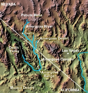
The Amargosa Valley is the valley through which the Amargosa River flows south, in Nye County, southwestern Nevada and Inyo County in the state of California. The south end is alternately called the "Amargosa River Valley'" or the "Tecopa Valley." Its northernmost point is around Beatty, Nevada and southernmost is Tecopa, California, where the Amargosa River enters into the Amargosa Canyon.
California Valley is an unincorporated community located in the eastern part of San Luis Obispo County, California, in the northern portion of the Carrizo Plain.

The Carrizo Plain is a large enclosed grassland plain, approximately 50 miles (80 km) long and up to 15 miles (24 km) across, in southeastern San Luis Obispo County, California, about 100 miles (160 km) northwest of Los Angeles. It contains the 246,812-acre (99,881 ha) Carrizo Plain National Monument, and it is the largest single native grassland remaining in California. It includes Painted Rock in the Carrizo Plain Rock Art Discontiguous District, which is listed on the National Register of Historic Places. In 2012 it was further designated a National Historic Landmark due to its archeological value. The San Andreas Fault occurs along the eastern edge of the Carrizo Plain at the western base of the Temblor Range.

The Amargosa Desert is located in Nye County in western Nevada, United States, along the California–Nevada border, comprising the northeastern portion of the geographic Amargosa Valley, north of the Ash Meadows National Wildlife Refuge.

Topaz Solar Farm is a 550 megawatt (MWAC) photovoltaic power station in San Luis Obispo County, California, United States. Construction on the project began in November 2011 and ended in November 2014. It is one of the world's largest solar farms. The $2.5 billion project includes 9 million CdTe photovoltaic modules based on thin-film technology, manufactured by U.S. company First Solar. The company also built, operates and maintains the project for MidAmerican Renewables, a Berkshire Hathaway company. Pacific Gas and Electric will buy the electricity under a 25-year power purchase agreement. According to First Solar, it created about 400 construction jobs.
The Bighorn Mountains are a mountain range of the Mojave Desert and Transverse Ranges, located in San Bernardino County, California. They are primarily within a Bureau of Land Management (BLM) protected area.

Solar power has been growing rapidly in the U.S. state of California because of high insolation, community support, declining solar costs, and a renewable portfolio standard which requires that 33% of California's electricity come from renewable resources by 2020, and 60% by 2030. Much of this is expected to come from solar power via photovoltaic facilities or concentrated solar power facilities.

The Ivanpah Solar Electric Generating System is a concentrated solar thermal plant in the Mojave Desert. It is located at the base of Clark Mountain in California, across the state line from Primm, Nevada. The plant has a gross capacity of 392 megawatts (MW). It deploys 173,500 heliostats, each with two mirrors focusing solar energy on boilers located on three 459 feet (140 m) tall solar power towers. The first unit of the system was connected to the electrical grid in September 2013 for an initial synchronisation test. The facility formally opened on February 13, 2014. In 2014, it was the world's largest solar thermal power station.
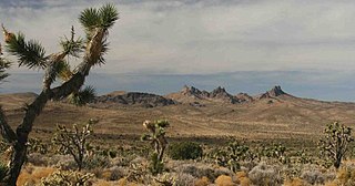
The Stateline Wilderness is a wilderness area located in San Bernardino County, California, approximately three miles northwest of Primm, Nevada and I-15. Having an area of approximately 7,004 acres (2,834 ha), it contains the eastern terminus of the 15-mile-long (24 km) Clark Mountain Range.
Panoche Valley Solar Farm is a 130 megawatt (MW), utility-scale solar photovoltaic power station in the Panoche Valley of Central California's San Benito County. Panoche Valley is crossed by a 230-kilovolt (kV) power line from the Moss Landing Power Plant.
The California Desert Protection Act of 2010 was legislation proposed by U.S. Senator Dianne Feinstein. The stated aim of the legislation was "to provide for conservation, enhanced recreation opportunities, and development of renewable energy in the California Desert Conservation Area."

The Blythe Mesa Solar Power Project, also known as the Blythe Solar Energy Center, is a 485 megawatt (MWAC) photovoltaic power plant near the city of Blythe in Riverside County, California. It occupies about 2,000 acres of public land managed by the Bureau of Land Management in the Mojave Desert. The construction uses CdTe thin film panels from the U.S. firm First Solar, and the majority of the output is being sold to Kaiser Permanente and Southern California Edison under 20-year power purchase agreements.
Solar Trust of America was an integrated solar industrial solutions company founded in 2009 and based in Oakland, California. The company was developing the Blythe Solar Power Project, the largest solar plant in the world in the Mojave Desert, among other projects. The company was noted for having turned down a $2.1 billion loan guarantee by the Department of Energy (DOE) for the construction of the Blythe project. Uwe T. Schmidt was CEO. On April 2, 2012, the company filed for Chapter 11 bankruptcy protection.
The McCoy Solar Energy Project is a 250 megawatt (MWAC) photovoltaic power plant near the city of Blythe in Riverside County, California. It occupies about 2,300 acres of mostly public land in the Mojave Desert. The construction uses CdTe thin film panels from First Solar, and the output is being sold to Southern California Edison under a power purchase agreement.

The Genesis Solar Energy Project is a concentrated solar power station located in the Mojave Desert on 1,920 acres (780 ha) of Bureau of Land Management land, in eastern Riverside County, California. The plant is owned/managed by Genesis Solar, LLC, a subsidiary of NextEra Energy Resources, LLC. The Genesis Solar Energy Project is located about 25 miles (40 km) west of Blythe, in the Lower Colorado River Valley. The plant was built in the Colorado Desert along an ancient trade route that native people had traveled for thousands of years. The route traversed the Sonoran Desert and enabled trade between the Colorado River and the coast.

Castle Mountains National Monument is a U.S. National Monument located in the eastern Mojave Desert and northeastern San Bernardino County, in the state of California.

Sand to Snow National Monument is a U.S. National Monument located in San Bernardino County and northern Riverside County, Southern California.

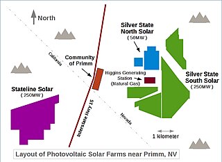
Desert Stateline Solar Facility is a 300 MWp utility-scale solar photovoltaic power station constructed by First Solar in San Bernardino County in California, USA. It is located at the base of Clark Mountain in California, across the state line from Primm, Nevada, and adjacent to the Ivanpah Solar Power Facility.
The Beacon Solar Project is a photovoltaic power station in the northwestern Mojave Desert, near California City in eastern Kern County, California. Split into five phases, the combined Beacon solar facilities generate 250 MW of renewable energy for the Los Angeles Department of Water and Power (LADWP). The five phases of the project, fully completed in December 2017, include a total of 903,434 individual solar photovoltaic modules, mounted onto Nextracker single-axis tracking systems.


