Metropolitan Fresno

Last updated • 5 min readFrom Wikipedia, The Free Encyclopedia

Metropolitan Fresno
Greater Fresno
Fresno–Hanford–Corcoran, CA CSA
Downtownfresnoskyline.jpg
Downtown Fresno skyline
Metropolitan Fresno
Map of Fresno–Hanford–Corcoran, CA CSA
Coordinates: 37°N120°W / 37°N 120°W / 37; -120
Country Flag of United States.svg United States
State Flag of California.svg California
Largest city Fresno
Other cities - Clovis
 - Madera
 - Chowchilla
 - Hanford
 - Corcoran
Area
  Total8,099 sq mi (20,980 km2)
Highest elevation
North Palisade 14,248 ft (4,343 m)
Lowest elevation
Chowchilla 180 ft (54.86 m)
Population
  Total1,171,617 (2,020 census)
  Rank 49th in the U.S.
GDP
[1]
  MSA$55.427 billion (2022)
Time zone UTC-8 (PST)
  Summer (DST) UTC-7 (PDT)

Metropolitan Fresno, officially Fresno–Hanford–Corcoran, CA CSA, is a metropolitan area in the San Joaquin Valley, in the United States, consisting of Fresno and Madera counties. It is the third-largest metropolitan region in Northern California, behind the San Francisco Bay Area and Greater Sacramento. It is also the 49th-largest CSA in the U.S. as of 2010 census. [2] [3]

Contents

Metropolitan Fresno is anchored by Fresno, the fifth-largest city in California and the 34th-largest in the United States. The metropolitan area is located in the Central Valley, which is one of the world's most productive agricultural regions. It has a large agricultural economy despite being increasingly urbanized. In more recent years, statewide droughts in California have further strained both the Fresno metropolitan area's and the entire Central Valley's water security. [4] [5]

Counties

County namePopulation (2020 U.S. Census)Land area
Fresno 1,013,400
Madera 158,217
Metropolitan Fresno1,171,617

Overview

Metropolitan Fresno, unlike the other metropolitan regions of California, is still largely agricultural, contains a large rural land area and is centered in the San Joaquin Valley. The metropolitan area is located between the larger metropolitan areas of California, bordering the southernmost boundaries of the San Francisco Bay Area in the west and separated from the Greater Sacramento and Greater Los Angeles Areas to the north and south respectively by long distances of rural areas and farmland. Additionally, the lifestyle and culture of Metropolitan Fresno does not reflect the San Francisco or Sacramento influence as other areas have in Northern California due to distance from the state capital and bordering an unpopulated area of the outskirts of the Bay Area. Instead, Metropolitan Fresno is more influenced by the interior valley region of California although as the area becomes more urbanized, it has become slightly more influenced by the other metropolitan areas of Northern California, particularly the Bay Area.

Fresno is the largest city in the area and in the Central Valley. Along with Sacramento, it is the economic center of California's interior and is one of the fastest-growing cities in the United States, with the region having a growth of over 20% since 2000. Fresno is a major transportation hub for visitors heading to Yosemite, Kings Canyon and Sequoia National Parks, which are 60 mi (97 km) and 75 mi (121 km) away from Fresno respectively with Fresno being the nearest major city from the parks. The United States Military has a heavy presence in the Fresno area and numerous divisions are based in Metropolitan Fresno, including the 40th Aviation Brigade and 144th Fighter Wing. [6] [7] Fresno County is the largest agricultural county and has the largest concentration of agriculture than any other county in the United States.

Madera County is primarily an agricultural county as well but its cities serve as suburbs of Fresno. Since 2010, statewide droughts in California have further strained both the Fresno metropolitan area's and the entire Central Valley's water security. [8] [9]

Geography and climate

Geography

Metropolitan Fresno is primarily located in the San Joaquin Valley, which in turn is a part of the larger Central Valley region of California, one of the world's most important agricultural areas. The eastern portions of the area border the Sierra Nevada mountains and the western portions border the Coast Ranges, thus giving the edges of the area higher elevations than the inner valley areas. Several waterways traverse the region, including the San Joaquin and Kings rivers, the Delta-Mendota and Madera canals, and the California Aqueduct, providing water to crops. The California Aqueduct is one of the world's longest artificial aqueducts. [10]

Climate

Metropolitan Fresno has a Mediterranean climate (Köppen Csa) with some semi-arid factors due to its interior location (Köppen Bsh), with mild, moderately wet winters and hot and dry summers. December is the coolest month, with an average of 53.4 °F (11.9 °C) during the day in downtown Fresno while summer temperatures can reach 110 °F (43.3 °C) or more. Thick tule fog is present in the valley areas during the winter. Rainfall is most common between December and April while snowfall is sometimes experienced in the higher mountain elevations.

Cities

County seat
CityCountyPopulation (January 1, 2010) [11] Land area [12]
Chowchilla Madera 18,698
Clovis Fresno 97,218
Coalinga Fresno 19,065
Firebaugh Fresno 6,941
Fowler Fresno 5,764
Fresno Fresno 502,303
Huron Fresno 8,062
Kerman Fresno 14,381
Kingsburg Fresno 11,504
Madera Madera 58,243
Mendota Fresno 9,966
Orange Cove Fresno 11,089
Parlier Fresno 13,658
Reedley Fresno 26,227
Sanger Fresno 25,664
San Joaquin Fresno 4,071
Selma Fresno 23,435

Census-designated places

Transportation

The Santa Fe Passenger Depot is the largest train station in Metropolitan Fresno. 2009-0725-CA-FresnoSantaFeStation.jpg
The Santa Fe Passenger Depot is the largest train station in Metropolitan Fresno.

Owing to its gateway location to numerous national parks as well as being in between the larger Greater Los Angeles and San Francisco Bay Area and Greater Sacramento regions, Metropolitan Fresno serves as a transportation hub in the California interior. However, unlike the larger metropolitan areas of California, Metropolitan Fresno does not have a large public transit system but is served by numerous freeways and highways.

Highways and freeways

Metropolitan Fresno is served by a large number of highways and freeways that are vital in linking the rest of Northern California with Southern California and its location in between the three larger metropolitan areas of the state allows for a large trucking industry as well as services to travelers. Highways and freeways in Metropolitan Fresno include:

Air

The Fresno Yosemite International Airport is the only commercial airport in the region and is the major gateway into Yosemite National Park, Sequoia National Park, and Kings Canyon National Park. Additionally, there are several general aviation airports in the area, including Fresno Chandler Executive Airport, Firebaugh Airport, Sierra Sky Park Airport and Madera Municipal Airport.

Public transit

Metropolitan Fresno's central California location allows it to be a large rail transport center. Two Amtrak rail stations are located in the area, Santa Fe Passenger Depot and Madera which are on the San Joaquin line. Fresno Area Express and Madera County Express serve as bus transit lines connecting to downtown Fresno. Greyhound and Orange Belt Stages provide long-distance bus travel to the area. California High Speed Rail, a currently under-construction high speed rail line, will connect Los Angeles and San Francisco via a station in Fresno and Madera.

Politics

Unlike the other metropolitan areas of California, Metropolitan Fresno has historically been a strong Republican stronghold and the region reflects the Coastal California and interior California divide in which coastal areas and urbanized areas of California tend to lean Democratic while interior areas tend to lean Republican. Exceptions to this are Orange County in Greater Los Angeles, which has been a Republican stronghold since the 1940s, and most of Greater Sacramento, which is a politically competitive area where the major parties are often divided in pluralities although recently there have been Democratic majorities. [13] Metropolitan Fresno has begun to become a politically competitive region as well, as in the 2008 presidential election, the region was split with Fresno County going for Barack Obama with the majority of the votes, while John McCain carried Madera County with a comfortable margin. Locally, Democratic concentrations are found in much of Fresno and most non-agricultural suburbs while Republican concentrations are found in Madera County and most rural towns.

Related Research Articles

<span class="mw-page-title-main">Sacramento County, California</span> County in California, United States

Sacramento County is a county located in the U.S. state of California. As of the 2020 census, the population was 1,585,055. Its county seat is Sacramento, which has been the state capital of California since 1854.

<span class="mw-page-title-main">Fresno County, California</span> County in California, United States

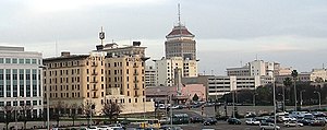
Fresno County, officially the County of Fresno, is a county located in the central portion of the U.S. state of California. As of the 2020 Census, the population was 1,008,654. The county seat is Fresno, the fifth-most populous city in California.

<span class="mw-page-title-main">Madera County, California</span> County in California, United States

Madera County, officially the County of Madera, is a county located at the geographic center of the U.S. state of California. It features a varied landscape, encompassing the eastern San Joaquin Valley and the central Sierra Nevada, with Madera serving as the county seat. Established in 1893 from part of Fresno County, Madera County reported a population of 156,255 in the 2020 census.

<span class="mw-page-title-main">San Joaquin County, California</span> County in California, United States

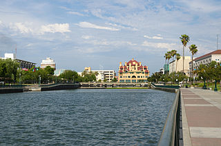
San Joaquin County, officially the County of San Joaquin, is a county located in the U.S. state of California. As of the 2020 census, the population was 779,233. The county seat is Stockton.

<span class="mw-page-title-main">Central Valley (California)</span> Flat valley that dominates central California

The Central Valley is a broad, elongated, flat valley that dominates the interior of California. It is 40–60 mi (60–100 km) wide and runs approximately 450 mi (720 km) from north-northwest to south-southeast, inland from and parallel to the Pacific coast of the state. It covers approximately 18,000 sq mi (47,000 km2), about 11% of California's land area. The valley is bounded by the Coast Ranges to the west and the Sierra Nevada to the east.

<span class="mw-page-title-main">Fresno, California</span> City in California, United States

Fresno is a major city in the San Joaquin Valley of California, United States. It is the county seat of Fresno County and the largest city in the greater Central Valley region. It covers about 115 square miles (300 km2) and had a population of 542,107 as of the 2020 census, making it the fifth-most populous city in California, the most populous inland city in California, and the 34th-most populous city in the nation.

<span class="mw-page-title-main">Oakhurst, California</span> Census-designated place in California, United States

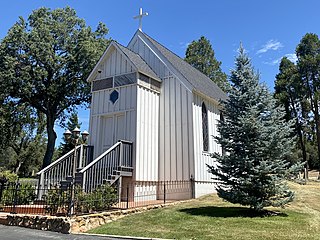
Oakhurst is a census-designated place (CDP) in Madera County, California, United States, 14 miles (23 km) south of the entrance to Yosemite National Park, in the foothills of the Sierra Nevada. At an elevation of 2,274 ft (693 m), Oakhurst is situated at the junction of Highway 41 and Highway 49, marking the southern end of California's Gold Country. It is part of the Madera metropolitan statistical area.

<span class="mw-page-title-main">Northern California</span> American geographic and cultural region

Northern California is a geographic and cultural region that comprises the northern portion of the U.S. state of California, spanning the northernmost 48 of the state's 58 counties. Northern California in its largest definition is determined by dividing the state into two regions, the other being Southern California. The main northern population centers include the San Francisco Bay Area, the Greater Sacramento area, the Redding, California, area south of the Cascade Range, and the Metropolitan Fresno area. Northern California also contains redwood forests, along with most of the Sierra Nevada, including Yosemite Valley and part of Lake Tahoe, Mount Shasta, and most of the Central Valley, one of the world's most productive agricultural regions. Northern California is also home to Silicon Valley, the global headquarters for some of the most powerful tech and Internet-related companies in the world, including Meta, Apple, Google, and Nvidia.

<span class="mw-page-title-main">San Joaquin River</span> Longest river of Central California, United States

The San Joaquin River is the longest river of Central California. The 366-mile (589 km) long river starts in the high Sierra Nevada, and flows through the rich agricultural region of the northern San Joaquin Valley before reaching Suisun Bay, San Francisco Bay, and the Pacific Ocean. An important source of irrigation water as well as a wildlife corridor, the San Joaquin is among the most heavily dammed and diverted of California's rivers.

<span class="mw-page-title-main">San Joaquin Valley</span> Area of the Central Valley in California

The San Joaquin Valley is the southern half of California's Central Valley. Famed as a major breadbasket, the San Joaquin Valley is an important source of food, producing a significant part of California's agricultural output.

<span class="mw-page-title-main">Sacramento Valley</span> Area of the Central Valley in California

The Sacramento Valley is the area of the Central Valley of the U.S. state of California that lies north of the Sacramento–San Joaquin River Delta and is drained by the Sacramento River. It encompasses all or parts of ten Northern California counties. Although many areas of the Sacramento Valley are rural, it contains several urban areas, including the state capital, Sacramento.

<span class="mw-page-title-main">California Aqueduct</span> Water supply project in California, US

The Governor Edmund G. Brown California Aqueduct is a system of canals, tunnels, and pipelines that conveys water collected from the Sierra Nevada Mountains and valleys of Northern and Central California to Southern California. Named after California Governor Edmund Gerald "Pat" Brown Sr., the over 400-mile (640 km) aqueduct is the principal feature of the California State Water Project.

<span class="mw-page-title-main">Bass Lake (Madera County, California)</span> Lake

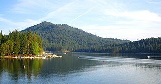
Bass Lake, situated in Madera County, California, within the Sierra National Forest and approximately 14 mi (23 km) south of Yosemite National Park, is a popular recreational area. The lake, formed by the Crane Valley Dam on Willow Creek, a tributary to the San Joaquin River, spans about four miles (6.4 km) in length and one-half mile (0.80 km) in width. Constructed in 1910 by Pacific Gas and Electric, the 145 ft (44 m) concrete gravity dam generates hydro-electric power through controlled releases. The lake supports a diverse ecosystem, including species such as black bears, mule deer, bald eagles, and Great blue herons, along with a variety of fish species.

<span class="mw-page-title-main">Central California</span> Region of California in the United States

Central California is generally thought of as the middle third of the U.S. state of California, north of Southern California and south of Northern California. It includes the northern portion of the San Joaquin Valley, part of the Central Coast, the central hills of the California Coast Ranges and the foothills and mountain areas of the central Sierra Nevada.

<span class="mw-page-title-main">Fresno River</span> River in California, United States

The Fresno River is a river in Central California and a major tributary of the San Joaquin River. It runs approximately 83 miles (134 km) from the Sierra Nevada Range to the San Joaquin River if measured from the source of Rainier Creek, near Raymond Mountain in Yosemite National Park. Although called the 'Fresno' River, it is one of the largest and longest river systems in Madera County.

<span class="mw-page-title-main">Sacramento metropolitan area</span> Metropolitan area in California, United States

The Greater Sacramento area refers to a metropolitan region in Northern California comprising either the U.S. Census Bureau defined Sacramento–Roseville–Arden-Arcade metropolitan statistical area or the larger Sacramento–Roseville combined statistical area, the latter of which consists of seven counties, namely Sacramento, Yolo, Placer, El Dorado, Sutter, Yuba, and Nevada counties.

<span class="mw-page-title-main">Outline of California</span> Overview of and topical guide to California

The following outline is provided as an overview of and topical guide to the U.S. state of California:

The San Joaquin Valley of California has seen environmental issues arise from agricultural production, industrial processing and the region's use as a transportation corridor.

The Central Valley in California subsides when groundwater is pumped faster than underground aquifers can be recharged. The Central Valley has been sinking (subsiding) at differing rates since the 1920s and is estimated to have sunk up to 28 feet. During drought years, the valley is prone to accelerated subsidence due to groundwater extraction. California periodically experiences droughts of varying lengths and severity.

References

  1. "Total Gross Domestic Product for Fresno, CA (MSA)". Federal Reserve Economic Data . Federal Reserve Bank of St. Louis.
  2. U.S. Census Bureau. Census 2000. "Census Demographic Profiles, Fresno County, California" (PDF). CenStats Databases. Retrieved January 31, 2009.{{cite web}}: CS1 maint: numeric names: authors list (link)[ dead link ]
  3. U.S. Census Bureau. Census 2000. "Census Demographic Profiles, Madera County, California" (PDF). CenStats Databases. Retrieved January 31, 2009.{{cite web}}: CS1 maint: numeric names: authors list (link)[ dead link ]
  4. "Groundwater Management and Drought: An Interview with the San Joaquin Valley Partnership". water.ca.gov. March 8, 2022. Retrieved May 1, 2022.
  5. amp.sacbee.com https://amp.sacbee.com/news/california/water-and-drought/article260869722.html . Retrieved May 1, 2022.{{cite web}}: Missing or empty |title= (help)[ title missing ]
  6. "Where Are The Divisions". Strategypage.com. November 8, 2004. Archived from the original on February 20, 2010. Retrieved July 2, 2010.
  7. John Pike. "Fresno Air National Guard Base". Globalsecurity.org. Retrieved July 2, 2010.
  8. "Groundwater Management and Drought: An Interview with the San Joaquin Valley Partnership". water.ca.gov. March 8, 2022. Retrieved May 1, 2022.
  9. amp.sacbee.com https://amp.sacbee.com/news/california/water-and-drought/article260869722.html . Retrieved May 1, 2022.{{cite web}}: Missing or empty |title= (help)[ title missing ]
  10. DWR Public Affairs Office (2005). "State Water Project Today". Department of Water Resources, State of California. Archived from the original on June 10, 2007. Retrieved March 19, 2009.
  11. "January 2010 Cities Ranked by Size, Numeric and Percent Change" (PDF). California Department of Finance. Archived from the original (Adobe Reader) on May 2, 2010. Retrieved May 7, 2010.
  12. "California – Place: GCT-PH1. Population, Housing Units, Area, and Density: 2000". United States Census Bureau. Archived from the original on February 12, 2020. Retrieved February 26, 2010.
  13. "Supplement to the Statement of Vote: Statewide Summary by County for United States President" (PDF). California Secretary of State. April 10, 2009. Archived from the original (PDF) on June 12, 2009. Retrieved August 21, 2009.

37°N120°W / 37°N 120°W / 37; -120